
Rattlesnakes are a group of venomous snakes of the genera Crotalus and Sistrurus of the subfamily Crotalinae. The scientific name Crotalus is derived from the Greek κρόταλον, meaning "castanet". The name Sistrurus is the Latinized form of the Greek word for "tail rattler" and shares its root with the ancient Egyptian musical instrument the sistrum, a type of rattle. The 36 known species of rattlesnakes have between 65 and 70 subspecies, all native to the Americas, ranging from southern Alberta and Saskatchewan and southern British Columbia in Canada to central Argentina.

The Issaquah Alps is the unofficial name for the highlands near Issaquah, Washington, a suburb of Seattle, including Cougar Mountain, Squak Mountain, Tiger Mountain, Taylor Mountain, Rattlesnake Ridge, Rattlesnake Mountain, and Grand Ridge. The term was invented in 1977 by noted nature author Harvey Manning within the pages of his trail guidebook Footsore 1, elevating their status from foothills to "Alps" to advocate preservation. Manning himself lived on a developed section of Cougar Mountain in his "200 meter hut".
Garfield Peak is a prominent mountain in the U.S. state of Wyoming. It is the highest point in the Rattlesnake Hills.
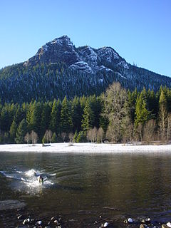
Rattlesnake Ridge is the ridge of Reattlesnake Mountain located south of North Bend, Washington, United States. The western end is near the intersection of State Route 18 and I-90 in Snoqualmie, Washington, and runs southeast about 7 miles (11 km) or 11 miles (18 km) by trail. It is the highest and easternmost of the Issaquah Alps. A maze of abandoned logging roads and constructed trails have been strung together to provide a 10.5-mile (16.9 km) footpath from the Snoqualmie Point trailhead at Exit 27 on I-90 all the way to the Rattlesnake Lake trailhead near Exit 32.

The Rattlesnake Wilderness is located in the U.S. state of Montana. Created by an act of Congress in 1980, the wilderness is within Lolo National Forest and is located only 4 miles (6.5 km) north of Missoula, Montana. The wilderness area is a component of the Rattlesnake National Recreation Area. It protects much of the high country of the Rattlesnake Mountains.

Redstone is an unincorporated community within the town of Conway in Carroll County, New Hampshire, United States. It is located on the road from Center Conway to North Conway at the base of Rattlesnake Mountain. From the late 19th century until circa 1950, Redstone was known for its quarry of "red" granite which was mined extensively.

Rattlesnake Mountain is a 3,531 ft windswept treeless sub-alpine ridge overlooking the Hanford nuclear site. Parts of the western slope are privately owned ranchland, while the eastern slope is under the federal protection of the Arid Lands Ecology Reserve, a unit of the Hanford Reach National Monument, managed by the United States Fish and Wildlife Service. The mountain is the second highest point in Benton County, with its neighbor Lookout Summit surpassing it by only 98 ft.
Rattlesnake Mountain is the name of 55 summits in the United States alone, including:
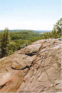
Rattlesnake Mountain is a traprock mountain, 750 feet (230 m) above sea level, located 9 miles (14 km) southwest of Hartford, Connecticut in the town of Farmington. It is part of the narrow, linear Metacomet Ridge that extends from Long Island Sound near New Haven, Connecticut, north through the Connecticut River Valley of Massachusetts to the Vermont border. Rattlesnake Mountain, a popular outdoor recreation resource of the metropolitan Hartford area, is known for its cliff-top scenic vistas, unique microclimate ecosystems, and rare plant communities. Will Warren's Den, a boulder cave located on the mountain, is a local historic site. Rattlesnake Mountain is traversed by the 51-mile (82 km) Metacomet Trail.
The Rattlesnake Hills, also known as Rattlesnake Ridge, is a 16-mile (26 km) long anticline mountain ridge in Yakima County and Benton County in the U.S. state of Washington. It should not be confused with the much smaller Rattlesnake Ridge located near the west end of Ahtanum Ridge. The highest point in the hills is the 3,629 feet (1,106 m) Lookout Summit, which surpasses the more well-known Rattlesnake Mountain by approximately 100 ft. The Rattlesnake Hills are part of the Yakima Fold Belt of east-tending long ridges formed by the folding of Miocene Columbia River basalt flows.

Ahtanum Ridge is a long anticline mountain ridge in Yakima County in the U.S. state of Washington. It is located just south of the city of Yakima, and much of its length is at the northern edge of the Yakama Indian Reservation.
The Meshomasic State Forest is located in East Hampton, Portland, and Marlborough, Connecticut, with smaller sections located in Glastonbury and Hebron. It is popular for mountain biking, hiking, and hunting. The Rangers Headquarters were located on Gadpouch Road in East Hampton.
Rattlesnake Mountain is a peak of the Kittatinny Mountains in Sussex County, New Jersey, United States. The mountain stands 1,489 feet (454 m) high. It lies along the Appalachian Trail in the Delaware Water Gap National Recreation Area. Located near the junction of Mullins Rd. (unmarked) and the Trail. Rattlesnakes like any of the rocky areas of the Kittatinny Ridge, for sunning themselve

Elm Tree Ridge is a mountain located in the Catskill Mountains of New York east of Hancock. Bittersweet Hill is located west, Rattlesnake Hill is located south, Big Fork Mountain is located east-southeast, and Johnny Ridge is located southwest of Elm Tree Ridge.
Cherry Ridge is a mountain located in the Catskill Mountains of New York southeast of Hancock. Taylor Hill is located west, Big Fork Mountain is located north, and Rattlesnake Hill is located northwest of Cherry Ridge.
Taylor Hill is a mountain located in the Catskill Mountains of New York southeast of Hancock. Jensen Hill is located west-southwest, Rattlesnake Hill is located west-northwest, Big Fork Mountain is located north-northeast, and Johnny Ridge is located northwest of Taylor Hill.
Jensen Hill is a mountain located in the Catskill Mountains of New York southeast of Hancock. Rattlesnake Hill is located north, Bouchoux Hill is located northwest, Big Fork Mountain is located northwest, and Taylor Hill is located east-northeast of Jensen Hill.
Bouchoux Hill is a mountain located in the Catskill Mountains of New York southeast of Hancock. Rattlesnake Hill is located northeast, Big Fork Mountain is located northeast, and Taylor Hill is located east-southeast of Bouchoux Hill.
Bittersweet Hill is a mountain located in the Catskill Mountains of New York east of Hancock. Hawk Mountain is located northwest, Jehu Mountain is located northwest, Rattlesnake Hill is located south-southwest, Big Fork Mountain is located east-southeast, and Johnny Ridge is located south of Bittersweet Hill.

Lookout Summit—officially listed as "Lookout" in the Geographic Names Information System—is the highest point in Benton County, in the U.S. state of Washington. The mountain is also the highest point in the Rattlesnake Hills, with an elevation 98 ft higher than the neighboring Rattlesnake Mountain, which is the second highest peak in the range.


