
The Cumberland Mountains are a mountain range in the southeastern section of the Appalachian Mountains. They are located in western Virginia, southwestern West Virginia, the eastern edges of Kentucky, and eastern middle Tennessee, including the Crab Orchard Mountains. Their highest peak, with an elevation of 4,223 feet (1,287 m) above mean sea level, is High Knob, which is located near Norton, Virginia.

The Tug Fork is a tributary of the Big Sandy River, 159 miles (256 km) long, in southwestern West Virginia, southwestern Virginia, and eastern Kentucky in the United States. Via the Big Sandy and Ohio rivers, it is part of the watershed of the Mississippi River.
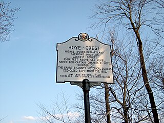
Backbone Mountain is a ridge of the Allegheny Mountains of the central Appalachian Mountain Range. It is situated in the U.S. states of West Virginia and Maryland and forms a portion of the Eastern Continental Divide. Within the state of Maryland, Backbone Mountain reaches an elevation of 3,360 feet or 1,024 metres, making it Maryland's highest point.

The Feather River is the principal tributary of the Sacramento River, in the Sacramento Valley of Northern California. The river's main stem is about 73 miles (117 km) long. Its length to its most distant headwater tributary is just over 210 miles (340 km). The main stem Feather River begins in Lake Oroville, where its four long tributary forks join—the South Fork, Middle Fork, North Fork, and West Branch Feather Rivers. These and other tributaries drain part of the northern Sierra Nevada, and the extreme southern Cascades, as well as a small portion of the Sacramento Valley. The total drainage basin is about 6,200 square miles (16,000 km2), with approximately 3,604 square miles (9,330 km2) above Lake Oroville.

The Columbia Mountains are a group of mountain ranges along the Upper Columbia River in British Columbia, Montana, Idaho and Washington. The mountain range covers 135,952 km². The range is bounded by the Rocky Mountain Trench on the east, and the Kootenai River on the south; their western boundary is the edge of the Interior Plateau. Seventy-five percent of the range is located in Canada and the remaining twenty-five percent in the United States; American geographic classifications place the Columbia Mountains as part of the Rocky Mountains complex, but this designation does not apply in Canada. Mount Sir Sandford is the highest mountain in the range, reaching 3,519 metres (11,545 ft).

Blue Mountain, Blue Mountain Ridge, or the Blue Mountains of Pennsylvania is a ridge of the Appalachian Mountains in eastern Pennsylvania. Forming the southern and eastern edge of the Ridge-and-Valley Appalachians physiographic province in Pennsylvania, Blue Mountain extends 150 miles (240 km) from the Delaware Water Gap on the New Jersey border in the east to Big Gap in Franklin County in south-central Pennsylvania at its southwestern end.

Frozen Head State Park and Natural Area is a state park in Morgan County, Tennessee, in the southeastern United States. The park, situated in the Crab Orchard Mountains between the city of Wartburg and the community of Petros, contains some of the highest mountains in Tennessee west of the Blue Ridge Mountains.

Reddish Knob of Shenandoah Mountain is one of the highest points in Virginia, rising 4,397 feet (1,340 m). A narrow, paved road reaches the summit from Harrisonburg, Virginia.
McKnight Mountain is the highest peak in the Black Range of southwestern New Mexico, in the southwestern United States. It is located about 30 miles (48 km) northeast of Silver City, in the Aldo Leopold Wilderness of the Gila National Forest.
Elk Pond Mountain is a peak of the Blue Ridge Mountains, on the border of Nelson and Rockbridge counties in Virginia. Elk Pond Mountain is flanked to the east by Maintop Mountain, and to the southwest by Rocky Mountain.

Graham Mountain is the seventh highest of the Catskill High Peaks and the highest privately owned mountain in the range. It is located in the town of Hardenburgh, New York, United States.

Mount Sterling is a mountain in the Great Smoky Mountains of Haywood County, North Carolina and Cocke County, Tennessee, located in the southeastern United States. It reaches an elevation of 5,842 feet (1,781 m) above sea level. The summit is topped by an abandoned fire tower that overlooks other nearby peaks.

Sacajawea Peak is a peak in the Wallowa Mountains, in the U.S. state of Oregon. It is in the Eagle Cap Wilderness and the Wallowa–Whitman National Forest.

The Rice Fork is a 22.7-mile-long (36.5 km) tributary of the Eel River in Lake County, California. The Rice Fork begins on the upper northwest side of Goat Mountain, on the Colusa-Lake County line, at an elevation of over 6,000 feet (1,800 m). It quickly descends the steep western slope of the mountain, then bends northward, and flows northwesterly down a narrow winding steep walled canyon for about 18 miles (29 km), crossing two forest roads and adding many tributaries, ending its journey at the southern tip of Lake Pillsbury, at a varied elevation around 1,800 feet (550 m), depending on the lake level. Before the construction of Scott Dam in the 1920s, which formed Lake Pillsbury, the Rice Fork ran directly into the Eel River. It is one of Lake County's longest streams.
Tomkins Mountain is a mountain in the North Carolina High Country, near the community of Deep Gap. The majority of the mountain is within the Blue Ridge Parkway. Its elevation reaches 4,075 feet (1,242 m) and it also marks the corner between Ashe, Watauga, and Wilkes counties.
Rich Mountain is a mountain located in the North Carolina High Country, roughly 3 miles (4.8 km) northwest of the town of Boone. Its elevation reaches 4,748 feet (1,447 m).
Smoky Dome, at 10,095 feet (3,077 m) above sea level is the highest peak in the Soldier Mountains of Idaho. Smoky Dome is located northwest of Fairfield in Camas County and Sawtooth National Forest.
Bittersweet Hill is a mountain located in the Catskill Mountains of New York east of Hancock. Hawk Mountain is located northwest, Jehu Mountain is located northwest, Rattlesnake Hill is located south-southwest, Big Fork Mountain is located east-southeast, and Johnny Ridge is located south of Bittersweet Hill.
Terrace Mountain is a mountain located in the Catskill Mountains of New York south-southwest of Phoenicia. Wittenberg Mountain is located southwest, Fork Ridge is located west-northwest, and Cross Mountain is located east of Terrace Mountain.

Mount Thompson is a 13,494-foot-elevation mountain summit located on the crest of the Sierra Nevada mountain range in California, United States. It is situated on the shared boundary of Kings Canyon National Park with John Muir Wilderness, and along the common border of Fresno County with Inyo County. It is also 18 miles (29 km) west of the community of Big Pine, one mile northwest of Mount Gilbert, and three miles east of Mount Fiske, which is the nearest higher neighbor. Mount Thompson ranks as the 62nd-highest summit in California. This mountain's name commemorates Almon Harris Thompson (1839–1906). The first ascent of the peak was made by Clarence H. Rhudy and H. F. Katzenbach in the summer of 1909.

