
Pickens County is a county located in the north-central portion of the U.S. state of Georgia. As of the 2020 census, the population was 33,216. The county seat is Jasper. Pickens County is part of the Atlanta-Sandy Springs-Roswell, Georgia metropolitan statistical area.

Westmont is a borough in Cambria County, Pennsylvania, United States. It is part of the Johnstown, Pennsylvania Metropolitan Statistical Area. The population was 5,181 at the 2010 census, down from 5,523 at the 2000 census.

The Blue Ridge Mountains are a physiographic province of the larger Appalachian Highlands range. The mountain range is located in the Eastern United States and extends 550 miles southwest from southern Pennsylvania through Maryland, West Virginia, Virginia, North Carolina, South Carolina, Tennessee, and Georgia. The province consists of northern and southern physiographic regions, which divide near the Roanoke River gap. To the west of the Blue Ridge, between it and the bulk of the Appalachians, lies the Great Appalachian Valley, bordered on the west by the Ridge and Valley province of the Appalachian range.

Sideling Hill, also Side Long Hill, is a long, steep, narrow mountain ridge in the Ridge-and-Valley physiographic province of the Appalachian Mountains, located in Washington County in western Maryland and adjacent West Virginia and Pennsylvania, USA. The highest point on the ridge is Fisher Point, at 2,310 feet (700 m) in Fulton County, Pennsylvania.

The South Mountains, known locally as simply South Mountain, is a mountain range in central Arizona in south Phoenix, Arizona. The majority of the range is public land managed by the City of Phoenix as South Mountain Park, but a small portion extends into the Gila River Indian Community.

Blue Mountain, Blue Mountain Ridge, or the Blue Mountains of Pennsylvania is a ridge of the Appalachian Mountains in eastern Pennsylvania. Forming the southern and eastern edge of the Ridge-and-Valley Appalachians physiographic province in Pennsylvania, Blue Mountain extends 150 miles (240 km) from the Delaware Water Gap on the New Jersey border in the east to Big Gap in Franklin County in south-central Pennsylvania at its southwestern end.

Short Hill Mountain is a mountain ridge of the Blue Ridge Mountains in northwest Loudoun County, Virginia.

Martin Hill is a mountain ridge which connects Tussey Mountain to its east and Evitts Mountain to its west. Martin Hill is located in the Martin Hill Wild Area, which is a part of the Buchanan State Forest, in Bedford County, Pennsylvania, United States. The summit of Martin Hill is one of the few in the Commonwealth which is void of any towers or transmitters; such equipment is located instead on a lesser nearby summit in the same mountain complex. Martin Hill is the second highest in Pennsylvania's Ridge and Valley Appalachians, the highest being Wills Mountain to its west at 2,780 ft (850 m).
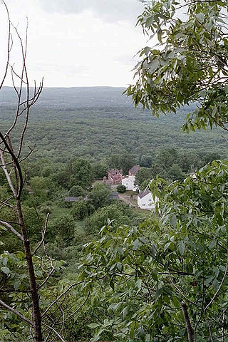
Peak Mountain, also called Copper Mountain, est. 730 feet (220 m), is a traprock mountain located in East Granby, Connecticut, 6 miles (10 km) south of the Massachusetts border and 6 miles west of the Connecticut River. It is part of the narrow, linear Metacomet Ridge that extends from Long Island Sound near New Haven, Connecticut, north through the Connecticut River Valley of Massachusetts to the Vermont border. Peak Mountain is known for its expansive views from 200 feet (61 m) high cliffs overlooking the historic Old Newgate Prison, Congamond Lake, and the Salmon Brook Valley of north-central Connecticut. The mountain is also known for its microclimate ecosystems, rare plant communities, and as a seasonal raptor migration path. It is traversed by the 51-mile (82 km) Metacomet Trail.

Vly Mountain is a mountain located in the town of Halcott, New York, United States in Greene County. The mountain is part of the Catskill Mountains. Vly Mountain is flanked to the northwest by Bearpen Mountain, to the east by Vinegar Hill, to the northeast by Kipp Hill, and to the southeast by Beech Ridge.

Halcott Mountain is one of the Catskill Mountains of the U.S. state of New York. It is mostly located in Greene County, with some of its lower slopes in Delaware and Ulster counties. Its exact summit elevation has not been officially determined, but the highest contour line on the mountain is 3,520 feet (1,070 m). It is one of the peaks on the divide between the Delaware and Hudson watersheds.
White Rock, 2,550 feet (780 m), is the high point on a 7 mi (11 km) ridgeline in the Taconic Mountains. The ridge is located in the tri-state corner of New York, Massachusetts, and Vermont in the towns of Petersburgh, Williamstown, and Pownal. The ridge has several distinct knobs; those with names are, from south to north: White Rocks, 2,365 feet (721 m); Smith Hill, 2,330 feet (710 m); White Rock, the high point 2,550 feet (780 m); and Bald Mountain 2,485 feet (757 m). The Snow Hole, located along the ridgeline between Bald Mountain and the White Rock, is a crevasse in which snow can be found well into the summer.

Mount Phillips, formerly called Clear Creek Mountain was renamed in 1960 in honor of the then living Waite Phillips, who donated the area to the Boy Scouts of America. It is located in Colfax County about 11 miles (18 km) south of Baldy Mountain in the Cimarron Range, a subrange of the Sangre de Cristo Mountains of New Mexico.
Doe Hill Mountain is a mountain in the North Carolina High Country, located northwest of Linville Falls. Though the mountain itself is undeveloped, it is flanked on all sides by tree farms and the following roads: US 221 to the east, NC 194 to the north, US 19E to the west and Brushy Creek Road (SR-1101) to the south. Pink Ridge form from the northern side of the mountain.
Chestnut Hill is a low mountain in Northampton County, Pennsylvania. The main peak rises to 722 feet (220 m), and is located in Forks Township; the southern slopes extend into the City of Easton where it is known as College Hill in allusion to Lafayette College. The neighborhood within Forks Township on the northern slopes of the mountain is known as Chestnut Hill.

The Darling Estate Historic Estate encompasses an historic country estate of more than 2,000 acres (810 ha) on Darling Hill Road, straddling the town line between Burke and Lyndon, Vermont. Built in the early 1900s for Elmer Darling, a locally-born New York hotelier, it was one of Vermont's largest such estates, featuring Burklyn Hall, one of its most opulent Colonial Revival houses, as well as numerous 19th-century farm properties. It was listed on the National Register of Historic Places in 2011.
Big Fork Mountain is a mountain located in the Catskill Mountains of New York southwest of Gregorytown. Stearns Hill is the variant name. Elm Tree Ridge is located west-northwest, Jehu Mountain is located west-northwest, and Cherry Ridge is located south of Big Fork Mountain.
Van Loan Hill is a mountain in Greene County, New York. It is located in the Catskill Mountains southwest of Maplecrest. Round Hill is located west, Elm Ridge is located north-northeast, and East Jewett Range is located south of Van Loan Hill.
Elm Ridge is a mountain in Greene County, New York. It is located in the Catskill Mountains north of Maplecrest. Van Loan Hill is located south-southwest of Elm Ridge.

