
Harrisonburg is a village in and the parish seat of Catahoula Parish, Louisiana, United States. The population was 348 as of the 2010 census, down from 746 in 2000.

Ray Township is a civil township of Macomb County in the U.S. state of Michigan. As of the 2020 census, the township population was 3,780.

Jvari is a town in the northwestern Georgian province of Samegrelo-Zemo Svaneti. The town is situated at an altitude of 280 metres near the Magana River where it flows into the Enguri River; The town is divided in two with "Jvari" lying on the Zugdidi-Mestia highway, and Jvarzeni up the hill.
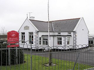
Erganagh is a small village and townland near Castlederg in County Tyrone, Northern Ireland. It is situated in the historic barony of Strabane Lower and the civil parish of Ardstraw. In the 2001 Census it had a population of 366 people. It is within the Strabane District Council area.
Huron Towers is the name of a pair of twin apartment buildings in Ann Arbor, Michigan.

Belotić or Mačvanski Belotić is a village in Serbia. It is situated in the Bogatić municipality, in the Mačva District. The village has a Serb ethnic majority and the population numbered 1,557 people in a 2011 census.
North Gem High School is a high school in Bancroft, Idaho. Grades K-12 are located in the same facility.
Göyməmmədli is a village in the Shamkir Rayon of Azerbaijan. The village forms part of the municipality of Qasımalılar.
Meşəli is a village in the Khachmaz Rayon of Azerbaijan. The village forms part of the municipality of Nabran.
The Canton of Rennes-Sud-Ouest is a former canton of France, in the Ille-et-Vilaine département. It had 34,059 inhabitants (2012). It was disbanded following the French canton reorganisation which came into effect in March 2015.

Kaludra is a village in Šumadija and Western Serbia (Šumadija), in the municipality of Rekovac, lying at 43°46′20″N21°03′38″E, at the elevation of 415 m. The village has less than 450 citizens.
View Lake is a small village located in Ontario, Canada. It is situated on the boundary of the Regional Municipality of Durham and the city of Kawartha Lakes, on the southern shores of Lake Scugog.
Chahal is a village in the Punjab province of Pakistan. It is located at 30°46'20N 74°10'20E with an altitude of 179 metres (590 feet).
Pasinogna is a former Tongva-Gabrieleño Native American settlement in San Bernardino County, California.
Lukavica is a village in the municipality of Dimitrovgrad, Serbia. According to the 2002 census, the village has a population of 429 people.
Mõisaküla is a village in Lääne-Nigula Parish, Lääne County, in western Estonia.
Woody's Roundup Village was a meet and greet area located in Frontierland in Disneyland Paris. It is based on the Disney·Pixar film series Toy Story. At the entrance of the farm stands a wooden house known as Woodcarver's Workshop. Originally, it was home to craftspeople carving guests' portraits on wood plaques. Although it closed in the early years of the park, it reopened with Woody's Village as a snack-delivering service. Repeatedly, projects of opening the ride Splash Mountain beside this attraction have been made, but none ever came true.
Saboba is a small town and is the capital of Saboba district, a district in the Northern Region of north Ghana. The primary economic activity is farming. Tribes like kokombas, kotokoli, chakosi and dagombas can be found in this district. Currently, Charles Bintin is the member of Parliament for Saboba and its neighbouring villages.

Kosovo field is a large karst field, located in the middle part of Kosovo. It is mostly known for being the site of the Battle of Kosovo (1389) between the Balkan Alliance led by Lazar of Serbia and Ottoman armies led by Murad I, and many other battles.
Mersin Free Zone is a free economic zone in Mersin, Turkey. It is in the Mediterranean Mersin Harbor area at 36°46′20″N34°39′00″E.
