
Wainaku is a census-designated place (CDP) in Hawaiʻi County, Hawaiʻi, United States. The population was 1,147 at the 2020 census.

Pennsbury Village is a borough in Allegheny County, Pennsylvania, United States. The population was 677 at the 2020 census.
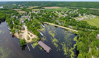
Bagley is a village in Grant County in the U.S. state of Wisconsin located on the Upper Mississippi River about 9 miles (15 km) south of Prairie du Chien, Wisconsin. The population was 379 at the 2010 census. It is a popular riverside destination in the summer, when the population can quadruple. The village was named for Vermont natives Alfred and Mary Bagley, who owned the site.

The Dartmouth Skiway is a ski area in the northeastern United States, in Lyme, New Hampshire. Located about twenty minutes northeast of Dartmouth College, it has thirty trails from easiest to most difficult on over one hundred acres (40 ha) of skiable area.
Lakewood is a village in Chautauqua County, New York, United States. The population was 2,993 at the 2020 census. The village is in the northern part of the town of Busti.
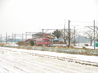
Tsukumo Station was a train station located on the Kurihara Den'en Railway Company Kurihara Den'en Railway Line in Kurihara, Miyagi Prefecture, Japan.

Boubín is a 1362 m high hill in the South Bohemian region of the Czech Republic. It is located 3.5 km east of the village of Kubova Huť. Most of the hill is covered by a primeval forest called Boubínský prales which, has been a natural preserve since 1858.
Trüttlikon is a village in the canton of Thurgau, Switzerland.

Shamiram, is a village in the Shamiram Municipality of the Aragatsotn Province of Armenia. It is mostly populated by Yazidis. The village is named after the Assyrian legendary queen Semiramis.

Seiryū-ji (青龍寺) is a Kōyasan Betsuin located in Aomori, Aomori Prefecture. The temple was founded by a Great Acharya Ryūkou Oda, who later built Shōwa Daibutsu (昭和大仏) in 1984. Roughly 21.35 meters in height, it is the tallest seated bronze figure of Buddha in Japan.
Phúc Sơn is a commune (xã) and village in Sơn Động District, Bắc Giang Province, in northeastern Vietnam.
Ketchen is a hamlet in the Canadian province of Saskatchewan.

Yuyaobei railway station is a railway station on the Hangzhou–Ningbo high-speed railway located in Zhejiang, China.

Zagreb City Museum or Museum of the City of Zagreb located in 20 Opatička Street, was established in 1907 by the Association of the Brethren of the Croatian Dragon.
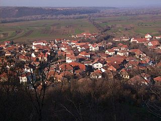
Kovilovo is a village in the municipality of Negotin, Serbia. According to the 2002 census, the village has a population of 411 people.
Bjeliši is a village in the municipality of Bar, Montenegro.
Rannaküla is a village in Saaremaa Parish, Saare County in western Estonia.
Viogor is a village in the municipality of Srebrenica, Bosnia and Herzegovina.

Kazan-Passazhirskaya is a railway station in the capital of Tatarstan — Kazan in Russia.
Toledo is an unincorporated community in Callaway County, in the U.S. state of Missouri. The community is on routes JJ and UU, approximately six miles east of Fulton.
