Uka was a rural locality in Karaginsky District of Koryak Autonomous Okrug, Soviet Union, located near the mouth of the Uka River, on the shore of the Bering Sea. It was served by Uka Airport. The village was abolished on December 13, 1974 as it was depopulated.
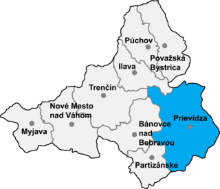
Poluvsie is a village and municipality in Prievidza District in the Trenčín Region of western Slovakia.
Gudur, Kurnool district is a village and a Mandal in Kurnool district in the state of Andhra Pradesh in India.

Bladowo-Wybudowanie is a village in the administrative district of Gmina Tuchola, within Tuchola County, Kuyavian-Pomeranian Voivodeship, in north-central Poland. It lies approximately 1 kilometre (1 mi) north-west of Tuchola and 55 km (34 mi) north of Bydgoszcz.
Spławy Drugie is a village in the administrative district of Gmina Kraśnik, within Kraśnik County, Lublin Voivodeship, in eastern Poland. It lies approximately 5 kilometres (3 mi) west of Kraśnik and 48 km (30 mi) south-west of the regional capital Lublin.

Drozdowo is a village in the administrative district of Gmina Piątnica, within Łomża County, Podlaskie Voivodeship, in north-eastern Poland. It lies approximately 6 kilometres (4 mi) south-east of Piątnica, 7 km (4 mi) east of Łomża, and 67 km (42 mi) west of the regional capital Białystok. The village has a population of 690.
Sabinów is a village in the administrative district of Gmina Konopnica, within Wieluń County, Łódź Voivodeship, in central Poland. It lies approximately 3 kilometres (2 mi) south-east of Konopnica, 24 km (15 mi) north-east of Wieluń, and 66 km (41 mi) south-west of the regional capital Łódź.
Małoszów is a village in the administrative district of Gmina Książ Wielki, within Miechów County, Lesser Poland Voivodeship, in southern Poland. It lies approximately 4 kilometres (2 mi) south of Książ Wielki, 11 km (7 mi) north-east of Miechów, and 42 km (26 mi) north of the regional capital Kraków.
Jankowice is a village in the administrative district of Gmina Ożarów, within Opatów County, Świętokrzyskie Voivodeship, in south-central Poland. It lies approximately 6 kilometres (4 mi) south of Ożarów, 19 km (12 mi) east of Opatów, and 76 km (47 mi) east of the regional capital Kielce.
Kobyle is a village in the administrative district of Gmina Frysztak, within Strzyżów County, Subcarpathian Voivodeship, in south-eastern Poland. It lies approximately 2 kilometres (1 mi) north-east of Frysztak, 12 km (7 mi) west of Strzyżów, and 35 km (22 mi) south-west of the regional capital Rzeszów.
Jezioro is a village in the administrative district of Gmina Żelechów, within Garwolin County, Masovian Voivodeship, in east-central Poland. It lies approximately 5 kilometres (3 mi) south-west of Żelechów, 20 km (12 mi) south-east of Garwolin, and 76 km (47 mi) south-east of Warsaw.
Martynów is a village in the administrative district of Gmina Chynów, within Grójec County, Masovian Voivodeship, in east-central Poland.
Baranek is a village in the administrative district of Gmina Strzegowo, within Mława County, Masovian Voivodeship, in east-central Poland.
Szlasy-Leszcze is a village in the administrative district of Gmina Krasne, within Przasnysz County, Masovian Voivodeship, in east-central Poland. It lies approximately 9 kilometres (6 mi) south of Przasnysz and 82 km (51 mi) north of Warsaw.
Janów is a village in the administrative district of Gmina Stare Babice, within Warsaw West County, Masovian Voivodeship, in east-central Poland. It lies approximately 2 kilometres (1 mi) north of Stare Babice, 7 km (4 mi) north-east of Ożarów Mazowiecki, and 12 km (7 mi) north-west of Warsaw.
Nowe Brzeźno is a village in the administrative district of Gmina Budzyń, within Chodzież County, Greater Poland Voivodeship, in west-central Poland.
Bierzów is a village in the administrative district of Gmina Kobyla Góra, within Ostrzeszów County, Greater Poland Voivodeship, in west-central Poland. It lies approximately 3 kilometres (2 mi) north of Kobyla Góra, 11 km (7 mi) west of Ostrzeszów, and 128 km (80 mi) south-east of the regional capital Poznań.
Bartodzieje is a village in the administrative district of Gmina Wągrowiec, within Wągrowiec County, Greater Poland Voivodeship, in west-central Poland. It lies approximately 6 kilometres (4 mi) north of Wągrowiec and 53 km (33 mi) north of the regional capital Poznań.

Kurtalići is a village in the municipality of Višegrad, Bosnia and Herzegovina.


