West Vračar or Zapadni Vračar, is a former urban neighborhood and municipality of Belgrade, the capital of Serbia. It was located in Belgrade's municipality of Savski Venac to which northern section it generally corresponds today.
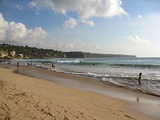
Dreamland Beach is a beach located on the Bukit peninsula, on the island of Bali, Indonesia. The beach provides basic accommodation and cafes for surfers and day-trippers. It is also renowned for its dangerous shorebreak.

San Giacomo is a mountain village in the Province of Teramo in the Abruzzo region of Italy. It is a frazione of the comune of Valle Castellana.

Say is a department of the Tillabéri Region in Niger. Its capital city is Say, and includes the towns of Guéladjo, Tamou, and Torodi. It abuts the urban Region of Niamey, and lies across the Niger River to the southwest of the capital. It extends to the Burkina Faso border over 60 km to the west, and the northernmost border with Benin in the south. The Say area is today divided between the riverine valley in the east of the Department, and the more sparsely populated areas to the west, which are intercut with a series of eastward flowing tributaries. The Niger river, a broad shallow channel at Niamey and at Say, passes through a series of gorges and cataracts, called the "W" bend for the shape the river takes, in the south of the Say Department. To the west of these rapids lies what is now the W Regional Park, a sparsely populated area historically plagued by insect borne diseases of both humans and cattle. Now a park and tourist attraction, its history as a "no mans land" has made it a refuge for remaining wild animals, as well as several undisturbed archeological sites. From at least the 16th century CE, the Zarma people moved south into this area from the northern plateau around what is now Oullam. The inhabitants at the time were related to the Gourma people, who form most of the population of the northwestern part of the Department today. In the 18th and 19th century, the town of Say was founded by Fulani migrants from the Gao region of modern Mali, with others expanding from what is now northeast Burkina Faso. Between 1810 and the arrival of European writer Heinrich Barth in 1854, Fulani Muslims led by Alfa Mohamed Diobo of Djenné had established the Emirate of Say. The reputation for piety and learning of Mohamed Diobo and his followers helped turn Say from a small river village into a town of 30,000, famed across West Africa as a center of learning.
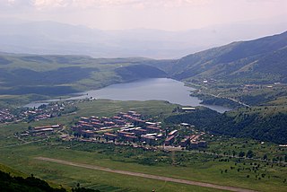
Kechut ; formerly known as Kushchi and Kush-Bilyak, is a former village in the Vayots Dzor Province of Armenia, currently part of the town of Jermuk. It is located at the south of the town, near the Jermuk airfield.

Gruszki is a village in the administrative district of Gmina Narewka, within Hajnówka County, Podlaskie Voivodeship, in north-eastern Poland, close to the border with Belarus. It lies approximately 3 kilometres (2 mi) east of Narewka, 19 km (12 mi) north-east of Hajnówka, and 54 km (34 mi) south-east of the regional capital Białystok.
Wiesiołów is a village in the administrative district of Gmina Dmosin, within Brzeziny County, Łódź Voivodeship, in central Poland. It lies approximately 4 kilometres (2 mi) east of Dmosin, 16 km (10 mi) north of Brzeziny, and 29 km (18 mi) north-east of the regional capital Łódź.
Szczepany is a village in the administrative district of Gmina Działoszyn, within Pajęczno County, Łódź Voivodeship, in central Poland. It lies approximately 7 kilometres (4 mi) south-west of Działoszyn, 17 km (11 mi) south-west of Pajęczno, and 91 km (57 mi) south-west of the regional capital Łódź.
Międzylesie is a village in the administrative district of Gmina Secemin, within Włoszczowa County, Świętokrzyskie Voivodeship, in south-central Poland. It lies approximately 4 kilometres (2 mi) north of Secemin, 10 km (6 mi) south-west of Włoszczowa, and 55 km (34 mi) west of the regional capital Kielce.
Drozdowo is a village in the administrative district of Gmina Rzewnie, within Maków County, Masovian Voivodeship, in east-central Poland.
Grądy Szlacheckie is a village in the administrative district of Gmina Długosiodło, within Wyszków County, Masovian Voivodeship, in east-central Poland.

Pèrèrè is a town, arrondissement, and commune in the Borgou Department of eastern Benin. The commune covers an area of 2017 square kilometres and as of 2002 had a population of 42,891 people.
Grzegorze is a village in the administrative district of Gmina Orzysz, within Pisz County, Warmian-Masurian Voivodeship, in northern Poland. It lies approximately 4 kilometres (2 mi) west of Orzysz, 22 km (14 mi) north of Pisz, and 92 km (57 mi) east of the regional capital Olsztyn.
Leszczno is a village in the administrative district of Gmina Przybiernów, within Goleniów County, West Pomeranian Voivodeship, in north-western Poland. It lies approximately 10 kilometres (6 mi) north-east of Przybiernów, 28 km (17 mi) north of Goleniów, and 47 km (29 mi) north-east of the regional capital Szczecin.

Gornja Vinča is a village in the municipality of Pale, Bosnia and Herzegovina.
Gornje Pale is a village in the municipality of Pale, Bosnia and Herzegovina.

Kot Chandi is a village of Lahore District in the Punjab province of Pakistan. It is located at 31°32'48N 73°47'58E with an altitude of 194 metres.
Ćoralići is a village in the municipality of Cazin, Bosnia and Herzegovina.
Suvojnica is a village in the municipality of Surdulica, Serbia. According to the 2002 census, the village has a population of 926 people.
Gornja Lijeska is a village in the municipality of Višegrad, Bosnia and Herzegovina.


