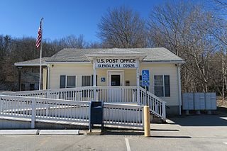
Glendale is a village in the town of Burrillville, Rhode Island, United States. It is located at 41°58′34″N71°37′59″W. The United States Postal Service has assigned Glendale the ZIP Code 02826.
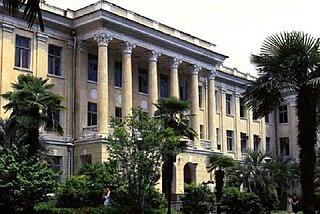
The Abkhazian State University is the only university in Abkhazia. It was founded in 1979 on the basis of the Sukhumi Pedagogical Institute. Its first rector was Zurab Anchabadze.

Mrganush, is a village in the Ararat Province of Armenia.

Juryzdyka is a village in the administrative district of Gmina Nowinka, within Augustów County, Podlaskie Voivodeship, in north-eastern Poland. It lies approximately 5 kilometres (3 mi) north of Nowinka, 14 km (9 mi) north of Augustów, and 97 km (60 mi) north of the regional capital Białystok.

Minbaşılı is a village in the Jabrayil Rayon of Azerbaijan.
Góry is a village in the administrative district of Gmina Uniejów, within Poddębice County, Łódź Voivodeship, in central Poland. It lies approximately 8 kilometres (5 mi) north-west of Uniejów, 22 km (14 mi) north-west of Poddębice, and 57 km (35 mi) north-west of the regional capital Łódź.
Opalanki is a village in the administrative district of Gmina Ozorków, within Zgierz County, Łódź Voivodeship, and in central Poland. It lies approximately 3 kilometres (2 mi) east of Ozorków, 16 km (10 mi) north-west of Zgierz, and 24 km (15 mi) north-west of the regional capital Łódź.
Wilczkowice is a village in the administrative district of Gmina Michałowice, within Kraków County, Lesser Poland Voivodeship, in southern Poland. It lies approximately 14 km (9 mi) north of the regional capital Kraków.
Kępa is a village in the administrative district of Gmina Kotuń, within Siedlce County, Masovian Voivodeship, in east-central Poland.
Karniszyn is a village in the administrative district of Gmina Bieżuń, within Żuromin County, Masovian Voivodeship, in east-central Poland. It lies approximately 4 kilometres (2 mi) north-east of Bieżuń, 11 km (7 mi) south of Żuromin, and 113 km (70 mi) north-west of Warsaw.
Wołcza Mała is a village in Gmina Miastko, Bytów County, Pomeranian Voivodeship, in northern Poland. It lies approximately 25 kilometres (16 mi) south-west of Bytów and 73 km (45 mi) south-west of Gdańsk.
Łówcz Górny is a village in the administrative district of Gmina Łęczyce, within Wejherowo County, Pomeranian Voivodeship, in northern Poland. It lies approximately 12 kilometres (7 mi) south-east of Łęczyce, 21 km (13 mi) south-west of Wejherowo, and 46 km (29 mi) west of the regional capital Gdańsk.
Martiany is a village in the administrative district of Gmina Kętrzyn, within Kętrzyn County, Warmian-Masurian Voivodeship, in northern Poland. It lies approximately 11 kilometres (7 mi) south-east of Kętrzyn and 73 km (45 mi) east of the regional capital Olsztyn.
Strzykocin is a village in the administrative district of Gmina Brojce, within Gryfice County, West Pomeranian Voivodeship, in north-western Poland. It lies approximately 3 kilometres (2 mi) north-east of Brojce, 15 km (9 mi) north-east of Gryfice, and 82 km (51 mi) north-east of the regional capital Szczecin.
Dymer is a village in the administrative district of Gmina Biskupiec, within Olsztyn County, Warmian-Masurian Voivodeship, in northern Poland. It lies approximately 8 kilometres (5 mi) south of Biskupiec and 32 km (20 mi) east of the regional capital Olsztyn.
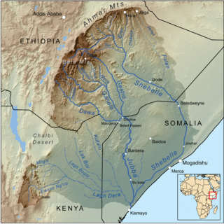
The Erer is a perennial river of eastern Ethiopia. It rises near the city of Harar, and flows in a primarily southern direction to its confluence with the Shabelle at 7°33′43″N42°01′43″E.

Rohozec is a village and municipality in Kutná Hora District in the Central Bohemian Region of the Czech Republic.
Akköy Dam is a dam in Kayseri Province, Turkey, built between 1964 and 1967.
Marquina is a village in Álava, Basque Country, Spain.
Unzá-Apreguíndana is a village in Álava, Basque Country, Spain.


