Gradašnica (Leskovac)

Last updated
Gradašnica
Градашница
Village
Crkva Svetog Arhangela Mihajla, Gradasnica, Leskovac, b13.JPG
Serbia adm location map.svg
Red pog.svg
Gradašnica
Coordinates: 43°02′34″N22°04′26″E / 43.04278°N 22.07389°E / 43.04278; 22.07389
CountryFlag of Serbia.svg  Serbia
District Jablanica District
Municipality Leskovac
Elevation 1,585 ft (483 m)
Population (2002)
  Total 472
Time zone CET (UTC+1)
  Summer (DST) CEST (UTC+2)

Gradašnica is a village in the municipality of Leskovac, Serbia. According to the 2002 census, the village has a population of 472 people. [1]

Village Small clustered human settlement smaller than a town

A village is a clustered human settlement or community, larger than a hamlet but smaller than a town, with a population ranging from a few hundred to a few thousand. Though villages are often located in rural areas, the term urban village is also applied to certain urban neighborhoods. Villages are normally permanent, with fixed dwellings; however, transient villages can occur. Further, the dwellings of a village are fairly close to one another, not scattered broadly over the landscape, as a dispersed settlement.

Leskovac City in Southern and Eastern Serbia, Serbia

Leskovac is a city and the administrative center of the Jablanica District in southern Serbia. According to the 2011 census, the city urban area has 60,288 inhabitants, while the city administrative area has 144,206.

Serbia Republic in Southeastern Europe

Serbia, officially the Republic of Serbia, is a country situated at the crossroads of Central and Southeast Europe in the southern Pannonian Plain and the central Balkans. The sovereign state borders Hungary to the north, Romania to the northeast, Bulgaria to the southeast, North Macedonia to the south, Croatia and Bosnia and Herzegovina to the west, and Montenegro to the southwest. The country claims a border with Albania through the disputed territory of Kosovo. Serbia's population is about seven million. Its capital, Belgrade, ranks among the oldest and largest citiеs in southeastern Europe.

Related Research Articles

Takovo Place in Moravica District, Serbia

Takovo is a village in the municipality of Gornji Milanovac, Serbia. According to the 2011 census, the village has a population of 458 people.

Přelovice Village in Pardubice District of Pardubice region

Přelovice is a small village in the Pardubice Region of the Czech Republic. It has around 190 inhabitants.

Hõralaid island

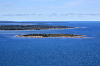
Hõralaid is a small, uninhabited Estonian island of approximately 20 hectares in the Baltic Sea. The coordinates of Hõralaid are 58°53′55″N23°04′26″E.

Wnorów, Lower Silesian Voivodeship Village in Lower Silesian, Poland

Wnorów is a village in the administrative district of Gmina Kostomłoty, within Środa Śląska County, Lower Silesian Voivodeship, in south-western Poland. Prior to 1945 it was in Germany.

Żuków-Kolonia is a village in the administrative district of Gmina Krzczonów, within Lublin County, Lublin Voivodeship, in eastern Poland.

Boczkowice, Świętokrzyskie Voivodeship Village in Świętokrzyskie, Poland

Boczkowice is a village in the administrative district of Gmina Włoszczowa, within Włoszczowa County, Świętokrzyskie Voivodeship, in south-central Poland. It lies approximately 12 kilometres (7 mi) south-east of Włoszczowa and 43 km (27 mi) west of the regional capital Kielce.

Obory is a village in the administrative district of Gmina Iłów, within Sochaczew County, Masovian Voivodeship, in east-central Poland.

Tremica is an archaeological site in Corsica. It consists of a dolmen with a semicircular capstone, and is located above the village of Casaglione.

Smolary, Czarnków-Trzcianka County Village in Greater Poland, Poland

Smolary is a village in the administrative district of Gmina Trzcianka, within Czarnków-Trzcianka County, Greater Poland Voivodeship, in west-central Poland. It lies approximately 8 kilometres (5 mi) west of Trzcianka, 22 km (14 mi) north-west of Czarnków, and 81 km (50 mi) north-west of the regional capital Poznań.

Ignacewo is a village in the administrative district of Gmina Chodów, within Koło County, Greater Poland Voivodeship, in west-central Poland.

Głodowo, Gmina Miastko Village in Pomeranian, Poland

Głodowo is a village in Gmina Miastko, Bytów County, Pomeranian Voivodeship, in northern Poland. It lies approximately 23 kilometres (14 mi) south-west of Bytów and 100 km (62 mi) south-west of Gdańsk.

Kałdowo, Malbork County Village in Pomeranian, Poland

Kałdowo is a village in the administrative district of Gmina Malbork, within Malbork County, Pomeranian Voivodeship, in northern Poland. It lies approximately 4 kilometres (2 mi) west of Malbork and 43 km (27 mi) south-east of the regional capital Gdańsk.

Kławki Village in Pomeranian, Poland

Kławki is a village in the administrative district of Gmina Stare Pole, within Malbork County, Pomeranian Voivodeship, in northern Poland. It lies approximately 3 kilometres (2 mi) south-east of Stare Pole, 13 km (8 mi) east of Malbork, and 53 km (33 mi) south-east of the regional capital Gdańsk.

Kożuchy Małe, Giżycko County Village in Warmian-Masurian, Poland

Kożuchy Małe is a village in the administrative district of Gmina Giżycko, within Giżycko County, Warmian-Masurian Voivodeship, in northern Poland. It lies approximately 9 kilometres (6 mi) east of Giżycko and 96 km (60 mi) east of the regional capital Olsztyn.

Mieczkówka is a village in the administrative district of Gmina Banie Mazurskie, within Gołdap County, Warmian-Masurian Voivodeship, in northern Poland, close to the border with the Kaliningrad Oblast of Russia.

Dzierżążnik is a village in the administrative district of Gmina Korsze, within Kętrzyn County, Warmian-Masurian Voivodeship, in northern Poland.

Dabinovac Village in Toplica District, Serbia

Dabinovac is a village in the municipality of Kuršumlija, Serbia. According to the 2002 census, the village has a population of 64 people.

Prisade Village in Republika Srpska, Bosnia and Herzegovina

Prisade is a village in the municipality of Doboj, Bosnia and Herzegovina.

Potkraj (Livno) Village in Federation of Bosnia and Herzegovina, Bosnia and Herzegovina

Potkraj is a village in the municipality of Livno, Bosnia and Herzegovina.

Dobrouščići Village in Republika Srpska, Bosnia and Herzegovina

Dobrouščići is a village in the Republika Srpska, Bosnia and Herzegovina. According to the 1991 census, the village is located in the municipality of Rogatica.

References

  1. Popis stanovništva, domaćinstava i Stanova 2002. Knjiga 1: Nacionalna ili etnička pripadnost po naseljima. Republika Srbija, Republički zavod za statistiku Beograd 2003. ISBN   86-84433-00-9

Coordinates: 43°02′34″N22°04′26″E / 43.04278°N 22.07389°E / 43.04278; 22.07389

Geographic coordinate system Coordinate system

A geographic coordinate system is a coordinate system that enables every location on Earth to be specified by a set of numbers, letters or symbols. The coordinates are often chosen such that one of the numbers represents a vertical position and two or three of the numbers represent a horizontal position; alternatively, a geographic position may be expressed in a combined three-dimensional Cartesian vector. A common choice of coordinates is latitude, longitude and elevation. To specify a location on a plane requires a map projection.