Sarıhacılı is a village in the Agdam Rayon of Azerbaijan.

Bayramly is a village in the Yevlakh Rayon of Azerbaijan.
Trzebieszów Drugi is a village in the administrative district of Gmina Trzebieszów, within Łuków County, Lublin Voivodeship, in eastern Poland.

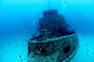
MV Rozi was a tugboat, built in Bristol in 1958. She was originally called Rossmore, and was later renamed Rossgarth. She was sold to Tug Malta in 1981 as the Rozi and operated in the Grand Harbour. After being decommissioned, she was scuttled off Ċirkewwa as an artificial reef. It is now one of the most popular dive sites in Malta.

Ostrówek Duży is a village in the administrative district of Gmina Zaleszany, within Stalowa Wola County, Subcarpathian Voivodeship, in south-eastern Poland. It lies approximately 8 kilometres (5 mi) south-east of Zaleszany, 6 km (4 mi) north-west of Stalowa Wola, and 65 km (40 mi) north of the regional capital Rzeszów.

Janów is a village in the administrative district of Gmina Karczew, within Otwock County, Masovian Voivodeship, in east-central Poland. It lies approximately 4 kilometres (2 mi) south-east of Karczew, 7 km (4 mi) south of Otwock, and 26 km (16 mi) south-east of Warsaw.
Rychnów-Kolonia is a village in the administrative district of Gmina Blizanów, within Kalisz County, Greater Poland Voivodeship, in west-central Poland.

Kiedrowice is a village in Gmina Lipnica, Bytów County, Pomeranian Voivodeship, in northern Poland. It lies approximately 12 kilometres (7 mi) south of Bytów and 55 km (34 mi) south-west of Gdańsk.

Wysoka Zaborska is a village in the administrative district of Gmina Brusy, within Chojnice County, Pomeranian Voivodeship, in northern Poland. It lies approximately 12 kilometres (7 mi) north of Brusy, 34 km (21 mi) north of Chojnice, and 75 km (47 mi) south-west of the regional capital Gdańsk.

Łubna is a village in the administrative district of Gmina Czersk, within Chojnice County, Pomeranian Voivodeship, in northern Poland. It lies approximately 3 kilometres (2 mi) north of Czersk, 32 km (20 mi) north-east of Chojnice, and 75 km (47 mi) south-west of the regional capital Gdańsk.

Drużno is a village in the administrative district of Gmina Elbląg, within Elbląg County, Warmian-Masurian Voivodeship, in northern Poland. It lies approximately 11 kilometres (7 mi) east of Elbląg and 70 km (43 mi) north-west of the regional capital Olsztyn.

Edwin is an unincorporated community in Amador County, California. It is located 1.5 miles (2.4 km) west-northwest of Ione on the Southern Pacific Railroad, at an elevation of 282 feet.
Pacujá is a municipality in the state of Ceará in the Northeast region of Brazil.

Obražda is a village in the municipality of Bojnik, Serbia. According to the 2002 census, the village has a population of 34 people.

Tulovo is a village in the municipality of Leskovac, Serbia. According to the 2002 census, the village has a population of 739 people.

Kupusina is a village in the municipality of Velika Plana, Serbia. According to the 2002 census, the village has a population of 267 people.
Regalado Highway is a 2.8-kilometre (1.7 mi), four-to-six-lane highway connecting Quirino Highway with Commonwealth Avenue. It is a main thoroughfare in the Barangay Greater Lagro to Mindanao Avenue and of the Neopolitan Business Park. It is named Regalado Highway to distinguish it from the nearby Regalado Avenue which is also a main road in the North Fairview area.

Zhongsheng station is a railway station on Line 10 of the Nanjing Metro. When it began operations on 3 September 2005, it was part of Nanjing Metro Line 1's Phase I from Maigaoqiao to Olympic Stadium. On 1 July 2014, with the opening of Line 10, the former branch of Line 1 from Andemen to Olympic Stadium became re-designated as Line 10.
Whitesville is an unincorporated community in Andrew County, in the U.S. state of Missouri.

Keçikalesi is a belde (town) in Niğde Province, Turkey


