Mosborough ward — which includes the districts of Halfway, Mosborough village, Waterthorpe, Westfield, as well as the rural area of Plumbley— is one of the 28 electoral wards in City of Sheffield, England. It is located in the eastern part of the city, on the border with Rotherham, and covers an area of 8.9 km2. The population of this ward in 2001 was 16,300 people in 7,000 households, the ward population increasing to 17,097 at the 2011 Census. It is one of the wards that make up the Sheffield South East constituency. The area is often referred to as Mosborough Townships. The population of the town increased to 17,097 in 2011 and is made up of 7,579 Households.

Lešnica is a village in western Serbia. It is located in the municipality of Loznica, in the Mačva District. Lešnica's current population is 4,731.

Thalavoor is a village located in the district of Kollam in the Kerala state of India. It is 77 km to the north of the State Capital, Thiruvananthapuram, and 28 km to the east of District Capital, Kollam. Thalavoor village is bordered by Pattazhy village to the north, Pidavoor village to the north-east, Vilakkudy village to the south-east, Melila village to the south and Mylom village to the west. Thalavoor is a part of Pathanapuram Block Panchayat

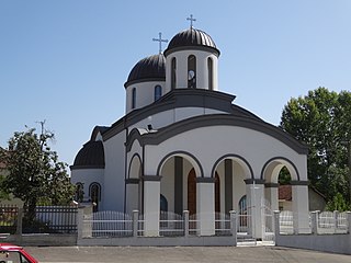
The Cathedral Church of the Nativity of the Theotokos is the largest Serbian Orthodox church in Sarajevo and one of the largest in the Balkans.

Căbești is a commune in Bihor County, Romania, around 13 kilometers north of the town of Beiuș.

Haibach is a community in the Aschaffenburg district in the Regierungsbezirk of Lower Franconia (Unterfranken) in Bavaria, Germany. It has a population of around 8,300.

Brajčino is a village in the Resen Municipality of the Republic of Macedonia, situated 6 kilometres (3.7 mi) from Lake Prespa, on Baba Mountain in Pelister National Park. The village is also located near the border with Greece. Brajčino's nature and old architecture draws both domestic and foreign tourists.
Čitluk is a settlement in Serbia near the city of Kruševac. It is often referred to as a village, since agriculture is still widespread, but the official status of the settlement is that it is a suburban area.
Ballylinney or Ballylinny is a small village and townland near Ballyclare in County Antrim, Northern Ireland. It is part of Antrim and Newtownabbey Borough Council.

Verin Dvin, is a village in the Ararat Province of Armenia located 30 kilometers south of Yerevan. The largest Assyrian community in Armenia is in Verin Dvin, where around 2,000 out of the 2,700 residents in the village are ethnic Assyrians. The village is home to 2 Assyrian churches including the church of Mar Tuma dating back to 1828. The village is built near the ruins of the ancient city of Dvin.
Szubin-Wieś is a village in the administrative district of Gmina Szubin, within Nakło County, Kuyavian-Pomeranian Voivodeship, in north-central Poland.

Namungoona is a neighborhood within Kampala, Uganda's capital and largest city.

Dešiška is a village in the municipality of Kuršumlija, Serbia. According to the 2002 census, the village has a population of 38 people.
Žalica is a village in the municipality of Kuršumlija, Serbia. According to the 2002 census, the village has a population of 12 people.
Đinđuša is a village in the municipality of Bojnik, Serbia. According to the 2002 census, the village has a population of 675 people.

Belanovce is a village in the municipality of Leskovac, Serbia. According to the 2002 census, the village has a population of 600 people.
Beli Potok is a village in the municipality of Leskovac, Serbia. According to the 2002 census, the village has a population of 629 people.

Nakrivanj is a village in the municipality of Leskovac, Serbia. According to the 2002 census, the village has a population of 1315 people.
Vlasina Rid is a village in the municipality of Surdulica, Serbia. According to the 2002 census, the village has a population of 276 people.

Podmočani is a village in the Resen Municipality of the Republic of North Macedonia, north of Lake Prespa. The village is roughly 8 kilometres (5.0 mi) from the municipal centre of Resen.