
Lužná is a village in the Central Bohemian Region of the Czech Republic. It has around 1,800 inhabitants.
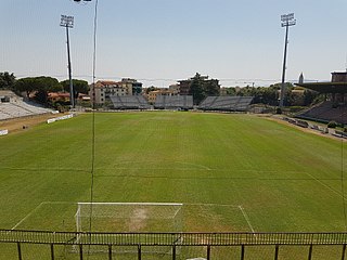
Stadio Marcello Melani is the main stadium in Pistoia, Italy. It is currently used mostly for football matches and is the home ground of U.S. Pistoiese 1921. The stadium holds 13,195.
Paniowice is a village in the administrative district of Gmina Oborniki Śląskie, within Trzebnica County, Lower Silesian Voivodeship, in south-western Poland. Prior to 1945 it was in Germany.

Czachowo is a village in the administrative district of Gmina Zawonia, within Trzebnica County, Lower Silesian Voivodeship, in south-western Poland.

Hatsik is a town in the Armavir Province of Armenia. The town was founded in 1933. It was named in honor of Kliment Voroshilov, a Soviet politician, and later called Nairi from 1963 to 1991. Population is 2973.
Mrgashat, is a major village in the Armavir Province of Armenia. A Bronze Age archaeological site is found near the village.
Stęszów is a village in the administrative district of Gmina Gidle, within Radomsko County, Łódź Voivodeship, in central Poland. It lies approximately 2 kilometres (1 mi) south of Gidle, 14 km (9 mi) south of Radomsko, and 94 km (58 mi) south of the regional capital Łódź.
Radoryż Smolany is a village in the administrative district of Gmina Krzywda, within Łuków County, Lublin Voivodeship, in eastern Poland. It lies approximately 5 kilometres (3 mi) west of Krzywda, 22 km (14 mi) south-west of Łuków, and 69 km (43 mi) north-west of the regional capital Lublin.
Gorzyce is a village in the administrative district of Gmina Tryńcza, within Przeworsk County, Subcarpathian Voivodeship, in south-eastern Poland. It lies approximately 5 kilometres (3 mi) south of Tryńcza, 9 km (6 mi) north-east of Przeworsk, and 43 km (27 mi) east of the regional capital Rzeszów.
Pacanówka is a village in the administrative district of Gmina Rytwiany, within Staszów County, Świętokrzyskie Voivodeship, in south-central Poland. It lies approximately 6 kilometres (4 mi) south-west of Rytwiany, 7 km (4 mi) south-west of Staszów, and 56 km (35 mi) south-east of the regional capital Kielce.
Iłówiec is a village in the administrative district of Gmina Mińsk Mazowiecki, within Mińsk County, Masovian Voivodeship, in east-central Poland.
Dąbrowa is a village in the administrative district of Gmina Mrozy, within Mińsk County, Masovian Voivodeship, in east-central Poland.
Strożęcin is a village in the administrative district of Gmina Raciąż, within Płońsk County, Masovian Voivodeship, in east-central Poland.
Mazowszany is a village in the administrative district of Gmina Kowala, within Radom County, Masovian Voivodeship, in east-central Poland. It lies approximately 5 kilometres (3 mi) north-east of Kowala, 7 km (4 mi) south of Radom, and 98 km (61 mi) south of Warsaw.
Mantgum is a small village in Leeuwarden municipality in the province Friesland of the Netherlands and had around 1,172 citizens in January 2017.
Stężyca is a village in the administrative district of Gmina Gostyń, within Gostyń County, Greater Poland Voivodeship, in west-central Poland. It lies approximately 8 kilometres (5 mi) north-west of Gostyń and 52 km (32 mi) south of the regional capital Poznań.
Kapustowo is a village in the administrative district of Gmina Malbork, within Malbork County, Pomeranian Voivodeship, in northern Poland. It lies approximately 7 kilometres (4 mi) west of Malbork and 41 km (25 mi) south-east of the regional capital Gdańsk.
Warblewo is a village in the administrative district of Gmina Polanów, within Koszalin County, West Pomeranian Voivodeship, in north-western Poland. It lies approximately 4 kilometres (2 mi) north-east of Polanów, 37 km (23 mi) east of Koszalin, and 162 km (101 mi) north-east of the regional capital Szczecin.

Hasanovići is a village in the municipality of Konjic, Bosnia and Herzegovina.

Koznica is a village in the municipality of Vladičin Han, Serbia. According to the 2002 census, the village has a population of 235 people.


