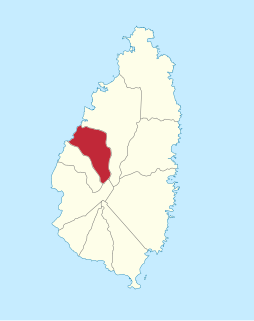
Anse la Raye is a Quarter on the West coast of St. Lucia in the Caribbean Sea. In 2001, the population of the region was 6,071 people, and they are mainly fishers and agricultural workers. The main town in the area takes the same name as the Quarter and is located at 13°55′N61°01′W, down the western coast from Castries, the capital of the country.

Roman (Роман) is a town in northwestern Bulgaria near the city of Pravets and about 90 km northeast of the capital of Bulgaria, Sofia. It is located in Vratsa Province and is known for the big steel factory, producing 100,000 tons of steel a year. The raw materials come from the Kremikovtsi factory near Sofia. As of December 2009, the town has a population of 3,157 inhabitants.
Paposh Nagar or Paposhnagar is one of the neighbourhoods of North Nazimabad Town in Karachi, Sindh, Pakistan.

Lozice is a small village in the Pardubice Region of the Czech Republic. It has around 160 inhabitants.
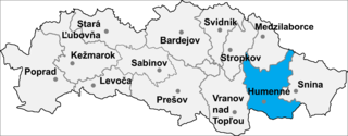
Nižné Ladičkovce is a village and municipality in Humenné District in the Prešov Region of north-east Slovakia.
Prödel is a former municipality in the Jerichower Land district, in Saxony-Anhalt, Germany. Since 1 January 2008, it is part of the town Gommern.

Metehara is a town in central Ethiopia. Located in the Misraq Shewa Zone of the Oromia Region, it has a latitude and longitude of 08°54′N39°55′E with an elevation of 947 meters above sea level.

Uhowo is a village in the administrative district of Gmina Łapy, within Białystok County, Podlaskie Voivodeship, in north-eastern Poland. It lies approximately 5 kilometres (3 mi) north-east of Łapy and 21 km (13 mi) south-west of the regional capital Białystok. Uhowo lies on the Narew River.

Brastavățu is a commune in Olt County, Romania. It is composed of two villages, Brastavățu and Crușovu.
Rona de Jos is a commune in Maramureș County, Romania. It is composed of a single village, Rona de Jos.

Lernagyugh is a small village in the Shirak Province of Armenia.

Dağilə is a village in the Hajigabul Rayon of Azerbaijan.

Graniczna is a village in the administrative district of Gmina Józefów nad Wisłą, within Opole Lubelskie County, Lublin Voivodeship, in eastern Poland. It lies approximately 16 kilometres (10 mi) south of Opole Lubelskie and 53 km (33 mi) south-west of the regional capital Lublin.
Kielanówka is a village in the administrative district of Gmina Boguchwała, within Rzeszów County, Subcarpathian Voivodeship, in south-eastern Poland. It lies approximately 4 kilometres (2 mi) north-west of Boguchwała and 7 km (4 mi) west of the regional capital Rzeszów.
Racławówka is a village in the administrative district of Gmina Boguchwała, within Rzeszów County, Subcarpathian Voivodeship, in south-eastern Poland. It lies approximately 4 kilometres (2 mi) north-west of Boguchwała and 7 km (4 mi) west of the regional capital Rzeszów.
Zbęchy is a village in the administrative district of Gmina Krzywiń, within Kościan County, Greater Poland Voivodeship, in west-central Poland. It lies approximately 9 kilometres (6 mi) north-east of Krzywiń, 20 km (12 mi) east of Kościan, and 43 km (27 mi) south of the regional capital Poznań.

Xuân La is a rural commune (xã) of Pác Nặm District, Bắc Kạn Province, in Vietnam.
Velakulam is a small town in Sri Lanka. It is located within Northern Province.

Donja Slatina is a village in the municipality of Leskovac, Serbia. According to the 2002 census, the village has a population of 300 people.
Yershovsky, Yershovskaya, or Yershovskoye is the name of several rural localities in Russia.


