
Igiugig is a census-designated place (CDP) in Lake and Peninsula Borough, Alaska, United States. The population was 68 at the 2020 census, up from 54 in 2010. The village is at the source of the Kvichak River, at the outlet of Lake Iliamna.

Baylis is a village in Pike County, Illinois, United States. The population was 200 at the 2010 census.

Ellis Grove is a village in Randolph County, Illinois, United States. The population was 328 at the 2020 census.

Yanbian University is a public university at Yanji, Yanbian, Jilin, China. It is affiliated with the Province of Jilin, and co-funded by the provincial government and the Ministry of Education. The university is part of Project 211 and the Double First-Class Construction.

Volente is a village in Travis County, Texas United States located on the north shore of Lake Travis. A post office was first established at Volente in 1886, with Andrew J. Stanford as postmaster but was not incorporated until 2003. The population was 561 at the 2020 census.
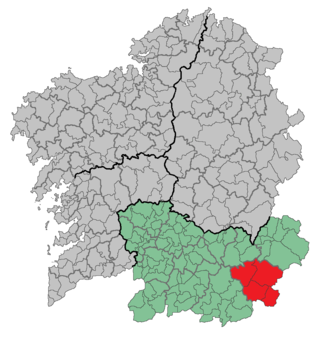
Viana is a comarca in the Galician Province of Ourense. The overall population of this local region was 5,682 in 2019.

The Dangsan Railway Bridge is a railway bridge that crosses the Han River in Seoul. It is used exclusively by Seoul Subway Line 2. Immediately on the south side of the bridge is Dangsan Station in Yeongdeungpo-gu, which is on an elevated platform. Hapjeong Station, a subterranean station in Mapo-gu, is located approximately 600 meters north of where the bridge makes landfall.
Geghadir is a village in the Tsaghkahovit Municipality of the Aragatsotn Province of Armenia.
Lernagog, is a village in the Armavir Province of Armenia. The village was formerly a sovkhoz. The village is sponsored by COAF Children of Armenia Fund and is one of the cleanest villages in Armenia. It has a very good school with the first creativity lab in Armenia.

Vahagni is a village in the Lori Province of Armenia.
Agamamedli is a village in the Saatly Rayon of Azerbaijan.

Kogane Station is a train station in Date, Hokkaidō, Japan.
Windthorst is a village in the Canadian province of Saskatchewan within the Rural Municipality of Chester No. 125 and Census Division No. 5.
Kašėtos is a village in Varėna district municipality, in Alytus County, in southeastern Lithuania. According to the 2001 census, the village has a population of 24 people.
Donje Krnjino is a village in the municipality of Babušnica, Serbia. According to the 2002 census, the village has a population of 271 people. It is around 15 km (9.3 mi) west of Pirot.
Stari Đurovac is a village in the municipality of Prokuplje, Serbia. According to the 2002 census, the village has a population of 15 people.
Sääsküla is a village in Kose Parish, Harju County in northern Estonia.
Vojinovac is a village in the municipality of Rača, Serbia. According to the 2002 census, the village has a population of 132 people.
Ouèdèmè-Pédah is an arrondissement in the Mono department of Benin. It is an administrative division under the jurisdiction of the commune of Comè. According to the population census conducted by the Institut National de la Statistique Benin on February 15, 2002, the arrondissement had a total population of 6,179.

Shan Ha Tsuen is a walled village in Yuen Long District, Hong Kong.

