
Nakagawa (Tokachi) is a district located in Tokachi Subprefecture, Hokkaido, Japan. There is a district with the same name in Kamikawa Subprefecture, see Nakagawa (Teshio) District, Hokkaido.

Aïn Turk nearby Bouira (Algeria) is a commune in Bouïra Province, Algeria. Not far from Aïn Turk is located viaduct - one of the biggest in Africa, with 200 meter main span and 120 meter stems. The viaduct is completed in October 2008, its total length is 745 metres. It is situated in the middle of the National Algerian Highway Project.

Sianky is a village in Lviv Oblast, Ukraine on the San River. It is located a few kilometers from the border with Poland, in the south-eastern part of Bieszczady. During 966 - 1018, 1340 - 1772 and 1918 - 1939 Sianky was the part of Poland, while during 1772 - 1918 it belonged to the Austrian empire. On September 17, 1939, Sianky was incorporated into the Soviet Union, and since the collapse of the Soviet Union in 1991, is part of independent Ukraine.

Jhando Mari is a town and union council of Tando Allahyar District in the Sindh Province of Pakistan. It is part of Jhando Mari Taluka and is located in the north of the district at 25°39′00″N68°54′0″E, the Union Council has a population of 30,384. D

Nowy Zambrzyków is a village in Otwock County, Gmina Sobienie-Jeziory.The population is near 50. In the village is Voivodship Road 801. From 1975 to 1998 village was in Siedlce Voivodeship. It lies approximately 4 kilometres (2 mi) south of Sobienie-Jeziory, 25 km (16 mi) south of Otwock, and 42 km (26 mi) south-east of Warsaw.

Făcăeni is a commune in Ialomița County, Romania. Its population was 5,953 at the 2002 census. The commune is composed of two villages, Făcăeni and Progresu.
Anielin is a village in the administrative district of Gmina Boniewo, within Włocławek County, Kuyavian-Pomeranian Voivodeship, in north-central Poland. It lies approximately 25 kilometres (16 mi) south-west of Włocławek and 68 km (42 mi) south of Toruń.
Kopaniny is a village in the administrative district of Gmina Zakrzówek, within Kraśnik County, Lublin Voivodeship, in eastern Poland.
Căzănești is a commune located in Mehedinți County, Romania. It is composed of twelve villages: Căzănești, Ercea, Gârbovățu de Sus, Govodarva, Ilovu, Jignița, Păltinișu, Poiana, Roșia, Severinești, Suharu and Valea Coșuștei.
Borki Prusinowskie is a village in the administrative district of Gmina Szadek, within Zduńska Wola County, Łódź Voivodeship, in central Poland. It lies approximately 8 kilometres (5 mi) north-west of Szadek, 18 km (11 mi) north of Zduńska Wola, and 40 km (25 mi) west of the regional capital Łódź.
Kotłówka is a village in the administrative district of Gmina Żelechów, within Garwolin County, Masovian Voivodeship, in east-central Poland. It lies approximately 3 kilometres (2 mi) east of Żelechów, 24 km (15 mi) south-east of Garwolin, and 80 km (50 mi) south-east of Warsaw.
Piotrowina is a village in the administrative district of Gmina Kałuszyn, within Mińsk County, Masovian Voivodeship, in east-central Poland.
Marianowo is a village in the administrative district of Gmina Wieleń, within Czarnków-Trzcianka County, Greater Poland Voivodeship, in west-central Poland.
Olendry is a village in the administrative district of Gmina Ceków-Kolonia, within Kalisz County, Greater Poland Voivodeship, in west-central Poland.

Qo‘ng‘irot District is a district of Karakalpakstan in Uzbekistan. The capital lies at Qo‘ng‘irot.

Vina is a village in the municipality of Leskovac, Serbia. According to the 2002 census, the village has a population of 232 people.
Vao is a village in Järva Parish, Järva County in northern-central Estonia.
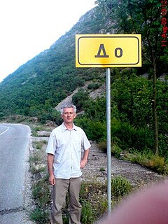
Do is a village in the municipality of Trebinje, Bosnia and Herzegovina.
Mendiguren is a village in Álava, Basque Country, Spain.
Dragocvet is a village in the municipality of Jagodina, Serbia. According to the 2002 census, the village has a population of 1003 people.


