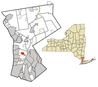
Elmsford is a village in Westchester County, New York, United States. It is part of the New York metropolitan area. Roughly one mile square, the village is fully contained within the borders of the town of Greenburgh. As of the 2010 census, the population of Elmsford was 4,664.
Madaras is a village in Bács-Kiskun county, Hungary.

Yukhari Askipara is a destroyed village within the Tavush Marz of Armenia. It is an exclave of the Qazakh Rayon of Azerbaijan. The exclave is surrounded by Armenia and has been occupied by Armenian forces since the Nagorno-Karabakh War which also included fighting in Qazakh. Today, the village is destroyed with only the foundations and some lower portions of the houses remaining. A cemetery is intact as is a children's playground used by the residents of neighboring Voskepar. The Armenian army expelled its Azerbaijani population after it occupied the territory, which Armenia administers as part of its Tavush Province.

Kaźmierzów is a village in the administrative district of Gmina Polkowice, within Polkowice County, Lower Silesian Voivodeship, in south-western Poland. It lies approximately 5 kilometres (3 mi) north of Polkowice, and 82 kilometres (51 mi) north-west of the regional capital Wrocław.

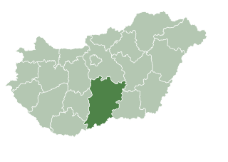
The Academy of Drama and Film in Budapest is a university founded in 1865 in Budapest, Hungary. The institution became a university in 2000 and the name has changed to University of Theatre and Film Arts.
Rogalin is a village in the administrative district of Gmina Horodło, within Hrubieszów County, in eastern Poland, close to the border with Ukraine.
Jamno is a village in the administrative district of Gmina Łowicz, within Łowicz County, Łódź Voivodeship, in central Poland. It lies approximately 6 kilometres (4 mi) south-west of Łowicz and 43 km (27 mi) north-east of the regional capital Łódź.
Lekaszyn is a village in the administrative district of Gmina Uniejów, within Poddębice County, Łódź Voivodeship, in central Poland. It lies approximately 12 kilometres (7 mi) north of Uniejów, 25 km (16 mi) north-west of Poddębice, and 59 km (37 mi) north-west of the regional capital Łódź.
Wola Niedźwiedzia is a village in the administrative district of Gmina Wartkowice, within Poddębice County, Łódź Voivodeship, in central Poland. It lies approximately 4 kilometres (2 mi) north-east of Wartkowice, 13 km (8 mi) north-east of Poddębice, and 37 km (23 mi) north-west of the regional capital Łódź.
Nieczajna Dolna is a village in the administrative district of Gmina Dąbrowa Tarnowska, within Dąbrowa County, Lesser Poland Voivodeship, in southern Poland.
Klimontówek is a village in the administrative district of Gmina Sędziszów, within Jędrzejów County, Świętokrzyskie Voivodeship, in south-central Poland. It lies approximately 8 kilometres (5 mi) south of Sędziszów, 22 km (14 mi) south-west of Jędrzejów, and 57 km (35 mi) south-west of the regional capital Kielce.
Krzesk-Królowa Niwa is a village in the administrative district of Gmina Zbuczyn, within Siedlce County, Masovian Voivodeship, in east-central Poland.
Nowy Koserz is a village in the administrative district of Gmina Chodów, within Koło County, Greater Poland Voivodeship, in west-central Poland.
Smokowo is a village in the administrative district of Gmina Kętrzyn, within Kętrzyn County, Warmian-Masurian Voivodeship, in northern Poland.

Thousand Lights is a multi-domed mosque in Anna Salai in Chennai, Tamil Nadu, India, is one of the largest mosques in the country and is a revered place of worship and azadari for Shia.

Drenča is a village in the municipality of Aleksandrovac, Serbia. The monastery of Drenča dates back to the Middle Ages. According to the 2002 census, the village has a population of 255 people.
Sudemäe is a village in Peipsiääre Parish, Tartu County in eastern Estonia.
Boukhanafis is a town and commune in Sidi Bel Abbès Province in northwestern Algeria.
Dekutince is a village in the municipality of Vladičin Han, Serbia. According to the 2002 census, the village has a population of 271.

Coast Guard Air Station Sitka Commanded by Commander Michael E. Frawley is an Air Station of the United States Coast Guard located in Sitka, Alaska. The station was originally established on Annette Island in March 1944, until relocating to Sitka in 1977. Early aircraft consisted of Grumman G-21's, PBY’s, HU-16’s, HH-52’s, and HH-3 Pelicans. Primary missions performed by the air station are Search and Rescue (SAR), law enforcement, and logistics covering the Southeast part of Alaska. Area of responsibility encompasses approximately 180,000 square miles of water and land extending across Southeast Alaska from Dixon Entrance to Icy Bay (Alaska), and from the Alaskan-Canadian border to the central Gulf of Alaska. This includes 12,000 miles of coastline distinguished by a rugged coast, mountainous terrain, severe weather, and many remote villages.