Shuswap Lake Marine Provincial Park is an 896-hectare provincial park in British Columbia, Canada, comprising 991 ha. The Park has a variety of amenities including boat launch ramps, picnic areas, and 27 campsites around the perimeter of Shuswap Lake. The lake's name and that of the surrounding Shuswap Country is from the Shuswap people (Secwepemc), the most northern of the Salishan speaking people.

Sianky is a village in Lviv Oblast, Ukraine on the San River. It is located a few kilometers from the border with Poland, in the south-eastern part of Bieszczady. During 966 - 1018, 1340 - 1772 and 1918 - 1939 Sianky was the part of Poland, while during 1772 - 1918 it belonged to the Austrian empire. On September 17, 1939, Sianky was incorporated into the Soviet Union, and since the collapse of the Soviet Union in 1991, is part of independent Ukraine.

Pavlovce is a village and municipality in the Rimavská Sobota District of the Banská Bystrica Region of southern Slovakia.

Pavlovce is a village and municipality in Vranov nad Topľou District in the Prešov Region of eastern Slovakia.
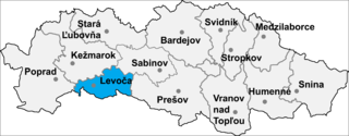
Lúčka is a village and municipality in Levoča District in the Prešov Region of central-eastern Slovakia.
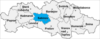
Červenica pri Sabinove is a village and municipality in Sabinov District in the Prešov Region of north-eastern Slovakia.
Podhradie is a village and municipality in Martin District in the Žilina Region of northern Slovakia.
The Kluskus First Nation is the band government of the Lhoosk’uz, a Dakelh people whose main reserve located on the Chilcotin Plateau 130 km west of the city of Quesnel, British Columbia, Canada. The First Nation is a member of the Carrier-Chilcotin Tribal Council, which includes both Tsilhqot'in and Carrier (Dakelh) communities.

Qasımkənd is a village in the Khizi Rayon of Azerbaijan. The village forms part of the municipality of Ağdərə.
Las-Grzęba is a village in the administrative district of Gmina Żyrzyn, within Puławy County, Lublin Voivodeship, in eastern Poland.
Zborówek Nowy is a village in the administrative district of Gmina Pacanów, within Busko County, Świętokrzyskie Voivodeship, in south-central Poland.

Miedniewice is a village in the administrative district of Gmina Wiskitki, within Żyrardów County, Masovian Voivodeship, in east-central Poland. It lies approximately 7 kilometres (4 mi) west of Wiskitki, 10 km (6 mi) west of Żyrardów, and 50 km (31 mi) west of Warsaw.
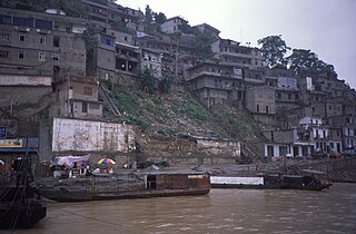
Wu Gorge, sometimes called Great Gorge, is the second gorge of the Three Gorges system on the Yangtze River, People's Republic of China. Formed by the Wu River, it stretches 45 km (28 mi) from Wushan to Guandukou, and is located downstream of Qutang Gorge and upstream of Xiling Gorge. The gorge straddles the boundary between Wushan County of Chongqing Municipality and Badong County, Hubei Province.
Czarnybród is a village in the administrative district of Gmina Grodziec, within Konin County, Greater Poland Voivodeship, in west-central Poland.

Petrovac is a village in the municipality of Leskovac, Serbia. According to the 2002 census, the village has a population of 108 people.
Vaigu-Rannaküla is a village in Saaremaa Parish, Saare County in western Estonia.
Đerekare is a village in the municipality of Tutin, Serbia. According to the 2002 census, the village has a population of 518 people.

Bujakovići is a village in the municipality of Srebrenica, Bosnia and Herzegovina.
Knez Selo is a village situated in Niš municipality in Serbia.


