The Suffolk Coast Path is a long-distance footpath along the Suffolk Heritage Coast in England. It is 50 miles (80 km) long.

The Suffolk Coast and Heaths AONB is an Area of Outstanding Natural Beauty in Suffolk and Essex, England.
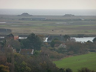
Orford Ness is a cuspate foreland shingle spit on the Suffolk coast in Great Britain, linked to the mainland at Aldeburgh and stretching along the coast to Orford and down to North Weir Point, opposite Shingle Street. It is divided from the mainland by the River Alde, and was formed by longshore drift along the coast. The material of the spit comes from places further north, such as Dunwich. Near the middle point of its length, at the foreland point or 'Ness', once stood Orfordness Lighthouse, demolished in summer 2020 owing to the encroaching sea. In the name of the lighthouse, 'Orfordness' is written as one word.
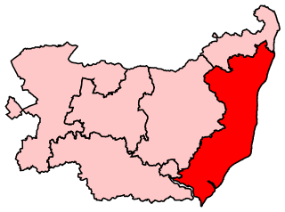
Suffolk Coastal is a parliamentary constituency in the county of Suffolk, England which has been represented in the House of Commons of the UK Parliament since 2010 by Thérèse Coffey, a Conservative Member of Parliament. She is formerly the Deputy Prime Minister of the United Kingdom and the Health Secretary. The constituency is in the far East of England, and borders the North Sea.

The River Alde and River Ore form a river system in Suffolk, England passing by Snape and Aldeburgh. The River Alde and River Ore meet northwest of Blaxhall. From there downriver the combined river is known as the River Alde past Snape and Aldeburgh, and then again as the River Ore as it approaches Orford and flows by a shingle spit before emptying into the North Sea.

Alderton is a village and civil parish in the East Suffolk district of Suffolk, England, about six miles north of Felixstowe, 10 miles south-east of Woodbridge and 2 miles south of Hollesley, on the North Sea coast and in the heart of the Suffolk Coast and Heaths Area of Outstanding Natural Beauty. In 2007 its population was 430, reducing to 423 at the 2011 Census.

The River Deben is a river in Suffolk rising to the west of Debenham, though a second, higher source runs south from the parish of Bedingfield. The river passes through Woodbridge, turning into a tidal estuary before entering the North Sea at Felixstowe Ferry. The mouth of the estuary is crossed by a ferry connecting Felixstowe and Bawdsey.

Felixstowe Ferry is a hamlet in Suffolk, England, approximately two miles northeast of Felixstowe at the mouth of the River Deben with a ferry to the Bawdsey peninsula.
National Cycle Route 51 is an English long distance cycle route running broadly east-west connecting Colchester and the port of Harwich to Oxford via Ipswich, Bury St Edmunds, Cambridge, Bedford, Milton Keynes, Bicester, and Kidlington.
Regional Cycle Route 42 is a regional bicycling route in Suffolk, England from Snape to Bramfield through the Suffolk Coast and Heaths, an Area of Outstanding Natural Beauty.
The ferries in Suffolk are a series of local ferry services in the county of Suffolk in Eastern England. Most cross rivers within the county, and one connects Suffolk with Essex to the south.

The Butley River or Butley Creek is a tributary of the River Ore in the English county of Suffolk. The river has its source in the Rendlesham Forest area to the east of Eyke.

Bawdsey Manor stands at a prominent position at the mouth of the River Deben close to the village of Bawdsey in Suffolk, England, about 75 miles (120 km) northeast of London. Built in 1886, it was enlarged in 1895 as the principal residence of Sir William Cuthbert Quilter. Requisitioned by the Devonshire Regiment during World War I and having been returned to the Quilter family after the war, it was purchased by the Air Ministry for £24,000 in 1936 to establish a new research station for developing the Chain Home RDF (radar) system. RAF Bawdsey was a base through the Cold War until the 1990s. The manor is now used by PGL for courses and children's holidays. There is a small museum in the radar transmitter block.
Wilford is a hundred of Suffolk, consisting of 31,500 acres (127 km2).

Alde–Ore Estuary is a 2,534 hectare biological and geological Site of Special Scientific Interest which stretches along the Suffolk coast between Aldeburgh and Bawdsey, and also includes parts of the Alde, Ore and Butley Rivers. It is in the Suffolk Coast and Heaths Area of Outstanding Natural Beauty, and is a Grade I Nature Conservation Review site, a Special Area of Conservation, a Ramsar internationally important wetland site, and a Special Protection Area under the European Union Directive on the Conservation of Wild Birds. It includes two Geological Conservation Review sites, "Orfordness and Shingle Street" and "The Cliff, Gedgrave", and two nature reserves managed by the Suffolk Wildlife Trust, Alde Mudflats and Simpson's Saltings. The coastal part of the site is Orfordness-Havergate, a National Nature Reserve, and Orford Ness is managed by the National Trust, while Havergate Island is managed by the Royal Society for the Protection of Birds.

Blaxhall Common is a nature reserve in the parish of Blaxhall in the East Suffolk District of Suffolk. The reserve is owned by Blaxhall Parish Council and managed by Suffolk Wildlife Trust. It is designated a 45.9-hectare (113-acre) biological Site of Special Scientific Interest as Blaxhall Heath. It is part of the Sandlings Special Protection Area under the European Union Directive on the Conservation of Wild Birds, and of the Suffolk Coast and Heaths Area of Outstanding Natural Beauty. A Bronze Age bowl barrow is a Scheduled Monument.

Sutton and Hollesley Heaths is a 483.3-hectare (1,194-acre) biological Site of Special Scientific Interest south-east of Woodbridge in Suffolk. Most of the site is managed by the Suffolk Wildlife Trust as Sutton and Hollesley Commons. It is part of the Sandlings Special Protection Area under the European Union Directive on the Conservation of Wild Birds, and the Suffolk Coast and Heaths Area of Outstanding Natural Beauty.

Bawdsey Cliff is a 17.4-hectare (43-acre) geological Site of Special Scientific Interest north-east of Felixstowe in Suffolk. It is a Geological Conservation Review site, and is in the Suffolk Coast and Heaths Area of Outstanding Natural Beauty.