
An arch bridge is a bridge with abutments at each end shaped as a curved arch. Arch bridges work by transferring the weight of the bridge and its loads partially into a horizontal thrust restrained by the abutments at either side. A viaduct may be made from a series of arches, although other more economical structures are typically used today.

Founded in 1996, the Naugatuck Railroad is a common carrier railroad owned by the Railroad Museum of New England and operated by Naugatuck Railroad on tracks leased by Naugatuck Railroad from the Connecticut Department of Transportation. The original Naugatuck Railroad was a railroad chartered to operate through south central Connecticut in 1845, with the first section opening for service in 1849. In 1887 the line was leased by the New York, New Haven and Hartford Railroad, and became wholly owned by 1906. At its greatest extent the Naugatuck ran from Bridgeport north to Winsted. Today's Naugatuck Railroad runs from Waterbury to the end of track in Torrington, Connecticut. From Waterbury south to the New Haven Line, Metro-North Railroad operates commuter service on the Waterbury Branch.

The Anoka–Champlin Mississippi River Bridge, also known as the Ferry Street Bridge, is a 10-span open spandrel concrete deck arch bridge that spans the Mississippi River between Anoka and Champlin, Minnesota, United States. It was built in 1929 by the Minneapolis Bridge Company, replacing an 1884 bridge at the same site.
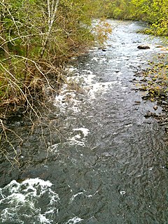
The Naugatuck River is a 40.2-mile-long (64.7 km) river in the U.S. state of Connecticut. Its waters carve out the Naugatuck River Valley in the western reaches of the state, flowing generally due south and eventually emptying into the Housatonic River at Derby, Connecticut and thence 11 miles (18 km) to Long Island Sound. The Plume and Atwood Dam in Thomaston, completed in 1960 following the Great Flood of 1955, creates a reservoir on the river and is the last barrier to salmon and trout migrating up from the sea.

The Lamar Boulevard Bridge is a historic arch bridge carrying Texas State Highway Loop 343 over Lady Bird Lake in downtown Austin, Texas, United States. The bridge features six open-spandrel concrete arches spanning 659 feet (201 m) and carries tens of thousands of vehicles daily across the lake. Completed in 1942, the Lamar Boulevard Bridge was the second permanent bridge to cross the Colorado River, and one of the last Art Deco-style open-spandrel concrete arch bridges built in Texas. The bridge was named an Austin Landmark in 1993 and added to the National Register of Historic Places in 1994.

Mattatuck State Forest is a Connecticut state forest spread over twenty parcels in the towns of Waterbury, Plymouth, Thomaston, Watertown, Litchfield, and Harwinton. The Naugatuck River runs through a portion of the forest. The largest section of the forest is located about 1 mile (1.6 km) north of Waterbury. The Leatherman's Cave, named after the vagabond Leatherman of the late 19th century, is located in Thomaston on the Mattatuck Trail, just north of the junction with the Jericho Trail.

The Hampden County Memorial Bridge is a reinforced-concrete arch bridge that spans the Connecticut River between Springfield, Massachusetts and West Springfield, Massachusetts, constructed in 1922. The bridge is owned by Massachusetts Highway Department and is located on Massachusetts Route 147. It spans 209 feet (64 m) and rises 29.71 feet (9.06 m) above the river.
The Housatonic River Railroad Bridge is a historic bridge carrying Metro-North Railroad's New Haven Line trackage across the lower Housatonic River in the U.S. state of Connecticut. The bridge is also used by Amtrak for its Northeast Corridor services. It was listed on the National Register of Historic Places in 1987, which also refers to the bridge as the Devon Bridge. It is also referred to as the Devon Railroad Bridge by the state Department of Environmental Protection.

The Kettle Falls Bridges is the collective name for a pair of steel cantilever bridges carrying State Route 20/U.S. Route 395 and the Kettle Falls International Railway across the Columbia River at Kettle Falls, Washington. The south bridge carries motor vehicle traffic while the similar northern span is used for rail.

The Cornwall Bridge is a two-lane, concrete arch bridge carrying U.S. Route 7/Connecticut Route 4 over the Housatonic River and the Housatonic Railroad in northwestern Connecticut. It was built in 1930 by C.W. Blakeslee and Sons for the Connecticut Highway Department and consists of six open-spandrel arches spanning 674 feet (205 m), and is a fairly large example of concrete open-spandrel construction. The bridge was reconstructed in 1994 and was listed on the National Register of Historic Places in 2004.

The Arrawanna Bridge is a historic bridge, spanning the Coginchaug River near Berlin Street in Middletown, Connecticut, USA. Built in 1918, it is an early example in the state of an open-spandrel concrete arch bridge, and is one of the state's oldest bridges. It was listed on the National Register of Historic Places in 2004. The bridge is now closed to all traffic.

Bridge No. 1132 is an open-spandrel concrete arch bridge carrying the two-lane Connecticut Route 80 across the Hammonasset River, between Killingworth and Madison, Connecticut. Built in 1934, it is one of a small number of open-spandrel concrete bridges in the state, and was noted for its aesthetics at the time of its construction. It was listed on the National Register of Historic Places in 2004.
The Old M-95–Michigamme River Bridge is a bridge located on Old M-95 as it passes over the Michigamme River in Republic Township, Michigan. It was listed on the National Register of Historic Places in 1999.

The East Putney Brook Stone Arch Bridge is a historic stone arch bridge in eastern Putney, Vermont. Built in 1902, it is a rare statewide example of a 20th-century stone bridge, and one of a number of such area bridges built by Townshend farmer and mason James Otis Follett. It was listed on the U.S. National Register of Historic Places in 1976. The bridge is located just west (upstream) of the present alignment of River Road, which it formerly carried.

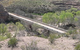
Ciénega Bridge is an open-spandrel arch bridge which crosses Ciénega Creek and the Union Pacific Railroad near Vail, Arizona. Originally constructed in 1921, the bridge was part of U.S. Route 80, a major transcontinental highway, from 1926 to 1956. Being the oldest bridge of its kind in Arizona, the Ciénega Bridge is listed on the National Register of Historic Places. Currently, the bridge carries Marsh Station Road.

The Fourche LaFave River Bridge carries Arkansas Highway 7 across the Fourche LaFave River in western Perry County, Arkansas, downstream of the Nimrod Dam. It is a three-span open spandrel concrete arch bridge, with its longest span measuring 184 feet (56 m), and its total length 518 feet (158 m). The arches are mounted on concrete abutments and piers. The bridge deck is asphalt, and is lined by ornate concrete balustrades. It was built in 1941 by the Luten Bridge Company, and is a well-preserved example of style from that period.

The Quechee Gorge Bridge is a historic bridge, carrying U.S. Route 4 (US 4) across Quechee Gorge, near the Quechee village of Hartford, Vermont. Built in 1911, it is Vermont's oldest surviving steel arch bridge. It was listed on the National Register of Historic Places in 1990.

Bridge No. 455 is a historic open spandrel concrete bridge, carrying Connecticut Route 159 across Stony Brook in southern Suffield, Connecticut. Completed in 1929, it is one of six surviving open spandrel concrete bridges in the state. It was listed on the National Register of Historic Places in 2004.

The Depot Street Bridge is a historic bridge in Beacon Falls, Connecticut, carrying Depot Street over the Naugatuck River. Built in 1935 with federal jobs relief funds, it is one of a small number of surviving Parker through truss bridges in the state. It was listed on the National Register of Historic Places in 2007.
The Gila River Bridge near Clifton, Arizona, also known as the Clifton Bridge, is a Luten Arch bridge which was built in 1918. It was listed on the National Register of Historic Places in 1988.

