
The Washington Monument is an obelisk-shaped building, on the National Mall in Washington, D.C., built to commemorate George Washington, a Founding Father of the United States, victorious commander-in-chief of the Continental Army from 1775 to 1784 in the American Revolutionary War, and the first President of the United States from 1789 to 1797. Standing east of the Reflecting Pool and the Lincoln Memorial, the monument, made of marble, granite, and bluestone gneiss, is both the world's tallest predominantly stone structure and the world's tallest obelisk, standing 554 feet 7+11⁄32 inches (169.046 m) tall, according to the U.S. Geodetic Survey measurements in 2013–2014. It is the tallest monumental column in the world if all are measured above their pedestrian entrances. It was the tallest structure in the world between 1884 and 1889, after which it was overtaken by the Eiffel Tower, in Paris. Previously, the tallest structure was the Cologne Cathedral.

The Phoenix Shot Tower, also known as the Old Baltimore Shot Tower, is a red brick shot tower, 234.25 feet (71.40 m) tall, located near the downtown, Jonestown, and Little Italy communities of East Baltimore, in Maryland. When it was completed in 1828 it was the tallest structure in the United States.

The Powder Magazine is a gunpowder magazine and museum at 79 Cumberland Street in Charleston, South Carolina, USA. Completed in 1713, it is the oldest surviving public building in the former Province of Carolina. It was used as a gunpowder store through the American Revolutionary War, and later saw other uses. The Powder Magazine was declared a National Historic Landmark in 1989. It has been operated as a museum by the National Society of the Colonial Dames of America since the early 1900s. It was designated a National Historic Landmark in 1972.

The Edna E. Lockwood is a Chesapeake Bay bugeye, the last working oyster boat of her kind. She is located at the Chesapeake Bay Maritime Museum in Saint Michaels, Maryland. She was built in 1889 at Tilghman Island, Maryland by John B. Harrison and is of nine-log construction, similar to the smaller log canoe, and was launched on October 5, 1889 for Daniel Haddaway, at a cost of $2,200. She worked for at least seven sets of owners from 1899 until 1967, and was then sailed as a yacht until donated to the museum in 1973. The museum undertook an extensive restoration of the Lockwood from 1975 through 1979, which restored the bugeye to its 1910 appearance with the "patent stern" that had been added sometime prior to that year. She is the last bugeye retaining the sailing rig and working appearance of the type. Her length is 53.5 feet (16.3 m), with a 15.25 feet (4.65 m) beam and a draft of 2.58 feet (0.79 m) with the centerboard up, and a maximum sail area of approximately 1700 square feet.

The S Bridge is a historic stone arch bridge, spanning Salt Fork about 4 miles (6.4 km) east of Old Washington, Ohio. Built in 1828, it is one of the best-preserved surviving bridges built for the westward expansion of the National Road from Wheeling, West Virginia to Columbus, Ohio. S bridges derive their name from the sharply curving approaches to the span. The bridge was designated a National Historic Landmark in 1964. The bridge is closed to traffic, and may be seen from Blend Road on the north and Rhinehart Road on the south.

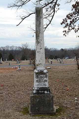
The Unknown Confederate Dead Monument in Perryville is located in the vicinity of Perryville, in Boyle County, Kentucky, United States, in the Goodknight Cemetery, a small family cemetery on private land. It is presumed to have been constructed around the year 1928, sixty-six years after the Battle of Perryville on October 8, 1862, in which the Confederate soldiers buried here anonymously died. In total, 532 Confederates died at the battle, but it is unknown how many of this number are buried here.

Arches National Park is a national park in eastern Utah, United States. The park is adjacent to the Colorado River, 4 mi (6 km) north of Moab, Utah. More than 2,000 natural sandstone arches are located in the park, including the well-known Delicate Arch, as well as a variety of unique geological resources and formations. The park contains the highest density of natural arches in the world.

The County Farm Bridge is a historic stone arch bridge in Wilton, New Hampshire. Built in 1885, it carries Old County Farm over Whiting Brook, just south of its northern junction with Burton Highway in a rural section of northwestern Wilton. It is an unusually late and well-preserved example of a 19th-century stone arch bridge, and was listed on the National Register of Historic Places in 1981.

Saints Peter and Paul Catholic Church is a former parish church of the Diocese of Davenport. The church is located in rural Solon, Iowa, United States. The property is on a gravel road east of Iowa Highway 1 between Solon and Mount Vernon in rural Johnson County. It was listed on the National Register of Historic Places in 1999.
St. Patrick's Catholic Church is a parish of the Diocese of Davenport. The church is located in rural Monroe County, Iowa, United States, on U.S. Highway 34, west of Albia, Iowa. It is located in an unincorporated area known as Georgetown and is listed on the National Register of Historic Places.

The Delaware County Courthouse, located in Manchester, Iowa, United States, was built in 1894. It was listed on the National Register of Historic Places in 1981 as a part of the County Courthouses in Iowa Thematic Resource. The current structure is the fourth building to house court functions and county administration.
Inscription "B" is a survey mark that was left at the confluence of the Colorado and Green rivers in Utah in 1889 by the Robert Brewster Stanton party as they surveyed a railway route.

Bridge No. 1860, also known as the Samson Occom Bridge, is a fieldstone arch bridge in Montville, Connecticut, United States. Constructed by the Connecticut State Highway Department in 1936 as a Works Progress Administration project, it is located on Mohegan tribal land in an area that was once a part of Fort Shantok State Park. The bridge carries traffic from Massapeag Side Road over the Shantok Brook, a tributary of the Thames River. Spanning 12 feet (3.7 m) across the brook, the bridge's arch rises about 6 feet (1.8 m) above the water. According to a 2011 Connecticut Department of Transportation report, it carries 1,100 vehicles per day. Samson Occom Bridge was listed on the National Register of Historic Places in 1993.

The Old Stone Congregational Church, also known as the First Congregational Church of Lyons, is a historic church in Lyons, Colorado, built in 1894-5 and listed on the National Register of Historic Places in 1976.

Meems Bottom Covered Bridge is a covered bridge in Shenandoah County, Virginia, United States. The bridge, at 204 feet (62 m), is the longest covered bridge in Virginia and one of the last that supports regular traffic. Near the town of Mount Jackson, the Meems Bottom Covered Bridge features a 200-foot single-span wooden Burr arch structure. Built in 1892 by Franklin Hiser Wissler, the wooden bridge over the North Fork of the Shenandoah River provided access to his apple orchards at Strathmore Farms. The bridge was listed on the National Register of Historic Places on June 10, 1975.

The Stone Arch Bridge is a stone arch railroad bridge in Keene, New Hampshire, United States. Built in 1847 to carry the Cheshire Railroad, it is one of the best-preserved pre-1850 stone arch bridges in the nation. The bridge was listed on the National Register of Historic Places in 2012, and the New Hampshire State Register of Historic Places in 2006. It now carries a multi-purpose rail trail.

Pulpit Rock Tower, also known as Pulpit Rock Base-End Station , is a historic military observation tower at 9 Davis Road in Rye, New Hampshire. Built in 1943 as part of the Harbor Defenses of Portsmouth, a series of military defenses around Portsmouth, it is the only one of fourteen World War II-era observation posts to survive. Now owned by the state, it is periodically open to the public, and maintained by a local non-profit organization. It was listed on the National Register of Historic Places in 2010.
The Clarksville Confederate Monument is located in the south-central section of Oakland Cemetery in Clarksville, Arkansas. It is a white marble obelisk, 10 feet (3.0 m) in height, which is 21.5 inches (55 cm) square at its base. It is mounted on a limestone pedestal 2 feet (0.61 m) square and 22 inches (56 cm) in height. The lower portion of the obelisk is carved with an inscription commemorating the Confederate war dead, and its spire is adorned with a floral pattern. It was placed about 1902 by the local chapter of the United Daughters of the Confederacy.

The Melan Bridge is located in Emma Sater Park on the east side of Rock Rapids, Iowa, United States. The 30-by-16-foot structure is believed to be the third reinforced concrete arch span built in the country. Austrian engineer Josef Melan developed a new system of concrete reinforcement for bridge construction in the early 1890s. A fellow Austrian, Fritz von Emperger, introduced the system in the United States, and obtained a patent for it in 1893.
The Germantown Township Bridge S-29 is a historic stone arch bridge over an unnamed stream on 278th Street in rural Turner County, South Dakota, southwest of Chancellor. Built in 1942, it is one of a modest number of bridges surviving in the county that was built with New Deal funding. It was listed on the National Register of Historic Places in 2000.

