
Grand County is a county on the east central edge of Utah, United States. As of the 2010 United States Census, the population was 9,225. Its county seat and largest city is Moab.

Moab is the largest city of, and the county seat on the southern edge of, Grand County in eastern Utah in the western United States, known for its dramatic scenery. The population was 5,046 at the 2010 census, and in 2018 the population was estimated to be 5,322. Moab attracts many tourists annually, mostly visitors to the nearby Arches and Canyonlands national parks. The town is a popular base for mountain bikers who ride the extensive network of trails including the Slickrock Trail, and for off-roaders who come for the annual Moab Jeep Safari.

Newspaper Rock State Historic Monument is a Utah state monument featuring a rock panel carved with one of the largest known collections of petroglyphs. It is located in San Juan County, Utah, along Utah State Route 211, 28 miles (45 km) northwest of Monticello and 53 miles (85 km) south of Moab.

Thompson Springs, also officially known for a time as just Thompson, is a small census-designated place in central Grand County, Utah, United States. The population was 39 at the 2010 census. The town is just north of the east-west highway route shared by Interstate 70, U.S. Route 6 and U.S. Route 50, between Crescent Junction and Cisco. Moab, the county seat, is 37 miles (60 km) to the south. Thompson Springs is located in high desert country at an elevation of 5,246 feet (1,599 m), with the Book Cliffs just to the north. The town's ZIP code is 84540.
State Route 128 (SR-128) is a 44.564-mile-long (71.719 km) state highway in the U.S. state of Utah. The entire length of the highway has been designated the Upper Colorado River Scenic Byway, as part of the Utah Scenic Byways program. This road also forms part of the Dinosaur Diamond Prehistoric Highway, a National Scenic Byway. Residents of Moab frequently refer to SR-128 as "the river road", after the Colorado River, which the highway follows.
Ninemile Canyon is a canyon, approximately 40 miles (64 km) long, located in Carbon and Duchesne counties in eastern Utah, United States. Promoted as "the world’s longest art gallery", the canyon is known for its extensive rock art, most of it created by the Fremont culture and the Ute people. The rock art, shelters, and granaries left behind by the Fremont make Ninemile Canyon a destination for archaeologists and tourists alike.

The Hole in the Rock Trail is a historic trail running east-southeast from the town of Escalante in southern Utah in the western United States. The Mormon trailblazers who established this trail crossed the Colorado River and ended their journey in the town of Bluff. The Hole-in-the-Rock expedition established the trail in 1879. The trail is located within the borders of the Grand Staircase-Escalante National Monument, the adjacent Glen Canyon National Recreation Area and federal Bureau of Land Management (BLM) public land to the east of the Colorado River. A geologic feature called the Hole in the Rock gave the trail its name. A modern unpaved road called the Hole-in-the-Rock Road closely follows this historic trail to the point where it enters the Glen Canyon National Recreation Area. The modern road is an important access route for visiting the Canyons of the Escalante and the Devils Garden. The trail is listed on the National Register of Historic Places, being added to that list in 1982.
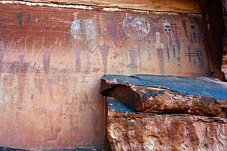
Barrier Canyon Style (BCS) describes a distinctive style of rock art which appears mostly in Utah, with the largest concentration of sites in and around the San Rafael Swell and Canyonlands National Park, but the full range extends into much of the state and western Colorado. The term was first applied by Polly Schaafsma to describe a handful of similar sites known at the time, including several along Barrier Creek in Horseshoe Canyon. Barrier Canyon Style rock art panels are mostly pictographs (painted) but there are also several petroglyphs (pecked) in the style. These panels are believed to have been created during the archaic period and are estimated to be somewhere in the range of 1500 to 4000 years old, possibly older -- clay figurines of a similar style found in Cowboy Cave have been dated to over 7000 years old.

The Dinosaur Diamond Prehistoric Highway is a 512-mile-long (824 km) National Scenic Byway in the U.S. states of Utah and Colorado. The highway forms a diamond-shaped loop with vertices at Moab, Helper, Vernal and Grand Junction.

Desolation Canyon is a remote canyon on the Green River in eastern Utah, United States that is listed on the National Register of Historic Places (NRHP). It is said to be one of the remotest areas in the contiguous United States.

Arches National Park is a national park in eastern Utah, United States. The park is adjacent to the Colorado River, 4 miles (6 km) north of Moab, Utah. More than 2,000 natural sandstone arches are located in the park, including the well-known Delicate Arch, as well as a variety of unique geological resources and formations. The park contains the highest density of natural arches in the world.

The Serpents Trail, also known as the Trail of the Serpents and the Serpentine Trail, is a trail within the Colorado National Monument in Mesa County, Colorado, United States, that is listed on the National Register of Historic Places.

The Zion – Mount Carmel Highway is a 25-mile (40 km) long road in Washington and Kane counties in southern Utah, United States, that is listed on the National Register of Historic Places and is a National Historic Civil Engineering Landmark.

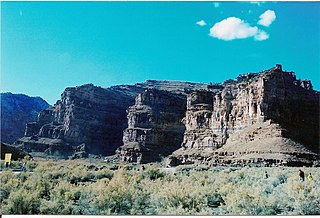
The Julien Inscription Panel is a rock face in Arches National Park that has been marked by passers-by who have incised their names into the desert varnish on the sandstone rock of the vertical rock face. Most of the signatures have been added since 1900. The most significant inscription was left by Denis Julien, a French-American trapper who traveled throughout the American southwest, leaving his mark as he went. The Julien inscription dates to June 9, 1844. The site also includes some prehistoric petroglyphs.

Cañon Pintado, meaning painted canyon, is an archaeological site of Native American rock art located in the East Four Mile Draw, 10.5 miles (16.9 km) south of Rangely in Rio Blanco County, Colorado. Led by Ute guides, the Domínguez–Escalante expedition, Spanish missionaries in search of a route to California in 1776, passed through this region as they moved north and then west into Utah. The first Europeans to the area, they named it Cañon Pintado, meaning "painted canyon".
The Bryce Canyon National Park Scenic Trails Historic District is a historic trail system in the central part of Bryce Canyon National Park in southwestern Garfield County, Utah, United States, that is listed on the National Register of Historic Places (NRHP).
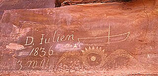
The Denis Julien Inscription is an incised carving on a rock face in a side canyon of the Green River north of Canyonlands National Park in southwestern Grand County, Utah, United States. The site is about 750 feet (230 m) to the east of the Green River in Hell Roaring Canyon, at the top of a talus slope. The inscription was left by trapper Denis Julien in 1836, when he was one of the few Europeans in southern Utah. The panel reads:
D. Julien
1836
3 mai

Seminole State Park and Historic Site is located on US Route 90, east of the Pecos River High Bridge, 9 miles (14 km) west of Comstock in Val Verde County in the U.S. state of Texas. The park is conducive to camping, biking, bird watching, back packing and archeological study. Cave art and archeological artifacts date back to the earliest human habitation in the area. The park is part of the larger Seminole Canyon Archeological District on the National Register of Historic Places listings in Val Verde County, Texas.
Archeological Site CA-INY-134, in Inyo County, California near Olancha, California, is an archeological site that is listed on the National Register of Historic Places (NRHP). The site is located in the Coso Range 6 miles (9.7 km) northwest of Coso Hot Springs. It has also been known as Ayer's Rock Pictograph Site, as Bob Rabbit's Pictographs, as INY-134 and as INY-105. Prehistorically, it served as a camp and as a ceremonial site. The site includes three pictograph panels carved into a monolith. The pictographs are painted in a variety of colors and depict animal and human figures.


