Poinsett County is a county located in the U.S. state of Arkansas. As of the 2010 census, the population was 24,583. The county seat is Harrisburg.
Petit Jean State Park is a 3,471-acre park in Conway County, Arkansas managed by the Arkansas Department of Parks and Tourism. It is located atop Petit Jean Mountain adjacent to the Arkansas River in the area between the Ouachita Mountains and Ozark Plateaus.
The St. Francis River is a tributary of the Mississippi River, about 426 miles (686 km) long, in southeastern Missouri and northeastern Arkansas in the United States. The river drains a mostly rural area and forms part of the Missouri-Arkansas state line along the western side of the Missouri Bootheel.

A spillway is a structure used to provide the controlled release of flows from a dam or levee into a downstream area, typically the riverbed of the dammed river itself. In the United Kingdom, they may be known as overflow channels. Spillways ensure that the water does not overflow and damage or destroy the dam.

Ridgewood Reservoir is a decommissioned 19th century reservoir that sits on the Brooklyn–Queens border in New York City, within what is now Highland Park. The reservoir itself is actually on the Queens side of the border in the neighborhood of Glendale. The reservoir and park are bounded on the north by the Jackie Robinson Parkway, on the south by Highland Boulevard, on the west by the backyards of homes on Bulwer Place and on the east by Cypress Hills National Cemetery.
U.S. Route 63 is a north-south U.S. highway that begins in Ruston, LA. In the US state of Arkansas the highway enters the state from Louisiana concurrent with US 167 in Junction City. The highway zigzags through the state serving the major cities of Pine Bluff, West Memphis and Jonesboro. The highway exits the state at Mammoth Spring traveling into Missouri.

Davidson Ditch is a 90-mile (140 km) conduit built in the 1920s to supply water to gold mining dredges in central Alaska. It was the first large-scale pipeline construction project in Alaska, and lessons learned in its construction were applied to the building of the Trans-Alaska Pipeline System. It is eligible for inclusion on the National Register of Historic Places, but has not been listed due to a lack of information. Despite this, the remains of the conduit are partially protected by its inclusion in the White Mountains National Recreation Area.

The historical buildings and structures of Zion National Park represent a variety of buildings, interpretive structures, signs and infrastructure associated with the National Park Service's operations in Zion National Park, Utah. Structures vary in size and scale from the Zion Lodge to road culverts and curbs, nearly all of which were designed using native materials and regional construction techniques in an adapted version of the National Park Service Rustic style. A number of the larger structures were designed by Gilbert Stanley Underwood, while many of the smaller structures were designed or coordinated with the National Park Service Branch of Plans and Designs. The bulk of the historic structures date to the 1920s and 1930s. Most of the structures of the 1930s were built using Civilian Conservation Corps labor.

Highway 136 is an east–west state highway in northeast Arkansas. The route of 7.87 miles (12.67 km) runs from Highway 135 near Rivervale east across Highway 140 to Highway 77 near Etowah.

This is a list of the National Register of Historic Places listings in Poinsett County, Arkansas.

The Grand Ditch, also known as the Grand River Ditch and originally known as the North Grand River Ditch, is a water diversion project in the Never Summer Mountains, in northern Colorado. It is 14.3 miles (23.0 km) long, 20 feet (6.1 m) wide, and 3 feet (0.91 m) deep on average. Streams and creeks that flow from the highest peaks of the Never Summer Mountains are diverted into the ditch, which flows over the Continental Divide at La Poudre Pass at 10,175 feet (3,101 m), delivering the water into Long Draw Reservoir and the Cache La Poudre River for eastern plains farmers. The water would otherwise have gone into the Colorado River that flows west towards the Pacific; instead, the Cache La Poudre River goes East and through the Mississippi River discharges into the Gulf of Mexico.

The Willie Lamb Post No. 26 American Legion Hut is a historic society meeting hall at 205 Alexander Street in Lepanto, Arkansas. It is a single story brick building with a side-gable roof, and a full-width shed-roof front porch supported by square posts. It was built in 1937-38 for the local chapter of the American Legion military fraternal organization, replacing an earlier building which had been built with funding assistance from the New Deal Civil Works Administration in 1932 which was flooded and then destroyed by fire. The building has long been a center of social activity in the community, as the site of dances, fundraising events, and other activities.

The Tyronza Water Tower is a historic elevated steel water tower located in Tyronza, Arkansas. It was built in 1935 by the Chicago Bridge & Iron Company in conjunction with the Public Works Administration as part of a project to improve the local water supply. It was added to the National Register of Historic Places in 2007, as part of a multiple-property listing that included numerous other New Deal-era projects throughout Arkansas. The Tyronza Water Tower is considered an excellent representation of 1930s-era waterworks construction.

Judd Hill is an unincorporated community in Poinsett County, Arkansas, United States. Judd Hill is located on Arkansas Highway 214, 5 miles (8.0 km) south of Trumann. The Judd Hill Cotton Gin, which is listed on the National Register of Historic Places, is located in Judd Hill. Judd Hill was named for banker and businessman Orange Judd Hill, who founded the community.

The Eller Beck is a small river in North Yorkshire, England, that flows through the town of Skipton and is a tributary of the River Aire. Its channel was heavily modified to supply water to mills in the 18th and 19th centuries, and although all the mills have closed, the water now supplies power to the National Grid, generated by a turbine at High Corn Mill. The beck flows through several underground culverts in Skipton that contribute to the flood risk. To alleviate flooding in Skipton town centre, a scheme involving two flood water storage reservoirs has been designed, but the start of the work to implement it was delayed in October 2014 by a shortfall in funding.

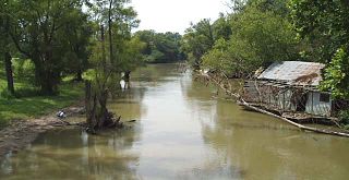
The Marked Tree Lock and Siphons are a flood control facility on the St. Francis River in Poinsett County, Arkansas. These facilities are located about 9 miles (14 km) north of Marked Tree. Built in 1926, the lock is located on a now disused and partially filled artificial channel west of the main river. It has a concrete trough about 130 feet (40 m) long and 30 feet (9.1 m) high, with a small brick control house from which four gates are operated to regulate water flow through the lock. The lock gates have been removed and that area filled in and topped by a roadway. The siphons are located on a levee that impounds the main river channel several hundred feet upstream from the lock, and consist of a series large metal tubes, whose ends are mounted in submerged concrete structures above and below the levee. The siphons were built in 1939 to solve the problem of water flow regulation in the wake of repeated major flooding events on the river, and are described by the United States Army Corps of Engineers as unique in the nation for their scope and efficiency.
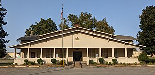
The Poinsett Community Club is a historic community center at Main and Poinsett Streets in Trumann, Arkansas. This large American Craftsman/Bungalow structure was designed by Watson B. Boggs and built in 1927, to provide a number of social resources to the employees of the Poinsett Lumber Company. The building was designed to house a gymnasium that doubles as a performing venue, meeting and classroom facilities, and a library. It has for many years been a major social center of the small community, hosting events, theatrical performances, and refugees from the area's periodic floods.
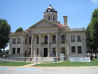
The Poinsett County Courthouse is located on a city block of downtown Harrisburg, Arkansas, bounded by Court, North Main, Market, and East Streets. It is a two-story granite and concrete structure, set on a raised foundation. The central block is topped by a tiled hip roof, with an octagonal tower set on a square base at its center. The front facade has a Classical Revival tetrastyle Corinthian portico with a fully enclosed gable pediment. Wings on either side of the main block are lower in height, but project beyond the main block's front and back. They are capped by low balustrade surrounding a flat roof. The courthouse was designed by Mitchell Seligman of Pine Bluff and built in 1917 to replace an earlier courthouse which had been destroyed by fire.

The Monona Township Culvert was a historic structure located southwest of Luana, Iowa, United States. It spanned an unnamed stream for 14 feet (4.3 m). Clayton County built a number bridges over rivers, streams and ditches around the turn of the 20th-century. They contracted with Frank Boyle to build this single stone arch culvert of native limestone in 1899. The culvert was listed on the National Register of Historic Places in 1998. It has subsequently been replaced.
The Read Township Culvert is a historic structure located southeast of Elkader, Iowa, United States. It spans an unnamed stream for 14 feet (4.3 m). Clayton County built a number of bridges over rivers, streams and ditches around the turn of the 20th-century. They contracted with local contrators Stoops and Williamson to build this single stone arch culvert of native limestone for $814.25. The culvert was listed on the National Register of Historic Places in 1999.


