Roff, Oklahoma

Last updated

Roff, Oklahoma
Nickname: 
Roff IT
OKMap-doton-Roff.PNG
Location of Roff, Oklahoma
Coordinates: 34°37′36″N96°50′28.5″W / 34.62667°N 96.841250°W / 34.62667; -96.841250
Country United States
State Oklahoma
County Pontotoc
Area
[1]
  Total0.93 sq mi (2.40 km2)
  Land0.92 sq mi (2.39 km2)
  Water0.00 sq mi (0.01 km2)
Elevation
[2]
1,253 ft (382 m)
Population
 (2020)
  Total632
  Density685.47/sq mi (264.56/km2)
Time zone UTC-6 (Central (CST))
  Summer (DST) UTC-5 (CDT)
ZIP code
74865
Area code 580
FIPS code 40-63750 [3]
GNIS feature ID2412569 [2]

Roff is a town in Pontotoc County, Oklahoma, United States. The population was 725 at the 2010 census.

Contents

Geography

According to the United States Census Bureau, the town has a total area of 0.9 square miles (2.3 km2), of which 0.9 square miles (2.3 km2) is land and 1.06% is water.

Demographics

Historical population
CensusPop.Note
1910 1,044
1920 1,1389.0%
1930 772−32.2%
1940 705−8.7%
1950 623−11.6%
1960 6382.4%
1970 632−0.9%
1980 72915.3%
1990 717−1.6%
2000 7342.4%
2010 725−1.2%
2020 632−12.8%
U.S. Decennial Census [4]

As of the census [3] of 2000, there were 734 people, 287 households, and 206 families residing in the town. The population density was 782.8 inhabitants per square mile (302.2/km2). There were 328 housing units at an average density of 349.8 per square mile (135.1/km2). The racial makeup of the town was 86.10% White, 0.14% African American, 10.35% Native American, 0.14% from other races, and 3.27% from two or more races. Hispanic or Latino of any race were 0.54% of the population.

There were 287 households, out of which 35.9% had children under the age of 18 living with them, 55.1% were married couples living together, 11.5% had a female householder with no husband present, and 28.2% were non-families. 26.5% of all households were made up of individuals, and 15.7% had someone living alone who was 65 years of age or older. The average household size was 2.56 and the average family size was 3.08.

In the town, the population was spread out, with 27.4% under the age of 18, 9.3% from 18 to 24, 27.5% from 25 to 44, 19.9% from 45 to 64, and 15.9% who were 65 years of age or older. The median age was 36 years. For every 100 females, there were 97.3 males. For every 100 females age 18 and over, there were 90.4 males.

The median income for a household in the town was $21,576, and the median income for a family was $30,156. Males had a median income of $30,125 versus $15,250 for females. The per capita income for the town was $12,157. About 19.0% of families and 18.8% of the population were below the poverty line, including 26.3% of those under age 18 and 7.9% of those age 65 or over.

History

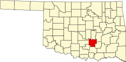
An incorporated community in Pontotoc County, Roff is situated along State Highway 1, eighteen miles southwest of Ada and ninety-five miles southeast of Oklahoma City. The town was named for Joseph T. Roff, a rancher who moved from Texas to the Chickasaw Nation, Indian Territory, in 1871. Roff and his Choctaw wife and children settled near the present townsite in 1883. A community developed along the nearby Blue River soon after Roff began leasing his land to whites in 1885. A subscription school was established there in 1889 and a post office, designated Roff, opened in June 1890. Joseph Roff served as postmaster.

The St. Louis, Oklahoma and Southern Railway (purchased by the St. Louis and San Francisco Railway in 1901) was constructed just south of Roff in December 1900. As a result, the village was relocated along the line and surveyed the following spring. A townsite company was then organized and community lots were sold. Joseph Roff was the town's first mayor.

Roff thrived as an agricultural community. Cotton gins, flour mills, and grain stores operated in town, and area farmers raised cotton, cattle, hogs, horses, and a variety of fruits. Other early businesses included a bottling works, a brick plant, and bakeries. The Mid-Continent Glass Sand Company was organized in 1912. Used in the manufacture of jars, tableware glasses, and containers, silicon dioxide (glass sand) remained a local export into the twenty-first century. The Roff Tribune, the Roff Enterprise, the Roff Eagle, and the Blue Valley Farmer were among the town's newspapers.

Roff's population was 1,079 at 1907 statehood. That number peaked at 1,138 in 1920. Roff's decline began when crop prices fell during the 1920s and continued through the Great Depression and World War II. The First State Bank of Roff closed in 1934, leaving the community without a bank until the 1970s. Local rail passenger service ceased in 1960. The population dropped from 772 in 1930 to 632 in 1970, but rose to 729 in 1980.

Roff had 734 residents and fifteen commercial enterprises in 2000. Businesses included a restaurant, an automobile dealership, two gasoline stations with convenience stores, and a housing construction firm. In 2000 the Roff School District enrolled 330 students. The Roff National Guard Armory was listed in the National Register of Historic Places (NR 97001151). [5]

Related Research Articles

<span class="mw-page-title-main">Pontotoc County, Oklahoma</span> County in Oklahoma, United States

Pontotoc County is in the south central part of Oklahoma. As of the 2020 census, the population was 38,065. Its county seat is Ada. The county was created at statehood from part of the Chickasaw Nation in Indian Territory. It was named for a historic Chickasaw tribal area in Mississippi. According to the Encyclopedia of Oklahoma History and Culture, Pontotoc is usually translated "cattail prairie" or "land of hanging grapes."

<span class="mw-page-title-main">Thaxton, Mississippi</span> Town in Mississippi, United States

Thaxton is a town in Pontotoc County, Mississippi, United States. The population was 643 at the 2010 census.

<span class="mw-page-title-main">Apache, Oklahoma</span> Town in Oklahoma, United States

Apache is a town in Caddo County, Oklahoma, United States. The population was 1,444 at the 2010 census.

<span class="mw-page-title-main">Union City, Oklahoma</span> Town in Oklahoma, United States

Union City is a town in Canadian County, Oklahoma, United States. The population was 1,645 at the 2010 census, a 19.6 percent increase from 1,375 in 2000. It is part of the Oklahoma City metropolitan statistical area.

<span class="mw-page-title-main">Pettit, Oklahoma</span> Census-designated place in Oklahoma, United States

Pettit is an unincorporated community and census-designated place (CDP) in Cherokee County, Oklahoma, United States. The population was 954 at the 2010 census, a 23.7 percent increase over the figure of 771 recorded in 2000. The town was named for Mark and Eliza Pettit, townsite allottees.

<span class="mw-page-title-main">Agra, Oklahoma</span> Town in Oklahoma, United States

Agra is a town in northern Lincoln County, Oklahoma, United States. The population was 339 at the 2010 census. An early real estate developer coined the town's name from the word "agriculture".

<span class="mw-page-title-main">Sparks, Oklahoma</span> Town in Oklahoma, United States

Sparks is a town in Lincoln County, Oklahoma, United States. The population was 169 at the 2010 census, a 23.4 percent gain from the figure of 137 in 2000. The center of population of Oklahoma is located in Sparks.

Meridian is a town in eastern Logan County, Oklahoma, United States. The population was 38 at the 2010 census, a decline of 29.5 percent from the figure of 54 in 2000. It is part of the Oklahoma City Metropolitan Statistical Area. The community name was chosen because of its location on the Indian meridian.

<span class="mw-page-title-main">Dibble, Oklahoma</span> Town in Oklahoma, United States

Dibble is a town in McClain County, Oklahoma, United States. The population within city limits was 867 at the 2020 census, down from 878 at the 2010 census. The community has 8,868 residents in its 73031 zipcode, according to Sperling's Best Places. Dibble is in the outer suburban area west of Purcell and southwest of Norman, in the Oklahoma City Metropolitan Area, according to the U.S. Census.

<span class="mw-page-title-main">Washington, Oklahoma</span> Town in Oklahoma, United States

Washington is a town in McClain County, Oklahoma, United States. The population was 673 as of the 2020 census, a 0.2% increase from 2010.

<span class="mw-page-title-main">Hickory, Oklahoma</span> Town in Oklahoma, United States

Hickory is a town in Murray County, Oklahoma, United States. The population was 87 at the 2000 census.

<span class="mw-page-title-main">Delaware, Oklahoma</span> Town in Oklahoma, United States

Delaware is a town in Nowata County, Oklahoma, United States. The population was 267 at the 2020 census, a decline of 35.9 percent from the figure of 417 recorded in 2010. The town is named for the Eastern Delaware tribe that moved into this area from Kansas after signing a treaty with the Cherokee Nation in 1867.

<span class="mw-page-title-main">Clearview, Oklahoma</span> Town in Oklahoma, United States

Clearview is a town in Okfuskee County, Oklahoma, United States. The population was 41 at the 2020 Census. It was historically an all-black freedmen's town and was platted by the Lincoln Townsite Company and designated as Lincoln.

<span class="mw-page-title-main">Fairfax, Oklahoma</span> Town in Oklahoma, United States

Fairfax is a town in Osage County, Oklahoma, United States. The Osage Nation reservation is coterminous with the county. The population was 1,380 at the 2010 census, down 11.3 percent from the figure of 1,555 recorded in 2000. It was the home of the ballerinas Maria and Marjorie Tallchief.

<span class="mw-page-title-main">Byng, Oklahoma</span> Town in Oklahoma, United States

Byng is a town in Pontotoc County, Oklahoma, United States. The population was 1,175 at the 2010 census.

<span class="mw-page-title-main">Fitzhugh, Oklahoma</span> Town in Pontotoc County, Oklahoma, United States

Fitzhugh is a town in Pontotoc County, Oklahoma, United States. The population was 204 at the 2000 census.

<span class="mw-page-title-main">Francis, Oklahoma</span> Town in Oklahoma, United States

Francis is a town in Pontotoc County, Oklahoma, United States. The population was 332 at the 2000 census.

<span class="mw-page-title-main">Stonewall, Oklahoma</span> Town in Oklahoma, United States

Stonewall is a town in Pontotoc County, Oklahoma, United States. Named for Confederate General Stonewall Jackson, the settlement's post office was established in December 1874.

Allen is a town in Hughes and Pontotoc counties in the U.S. state of Oklahoma. The population was 805 at the 2020 census.

<span class="mw-page-title-main">Two Rivers (town), Wisconsin</span> Town in Wisconsin, United States

Two Rivers is a town in Manitowoc County, Wisconsin, United States. The population was 1,912 at the 2000 census. The City of Two Rivers is located mostly within the town. The unincorporated community of Shoto is also located in the town.

References

  1. "ArcGIS REST Services Directory". United States Census Bureau. Retrieved September 20, 2022.
  2. 1 2 U.S. Geological Survey Geographic Names Information System: Roff, Oklahoma
  3. 1 2 "U.S. Census website". United States Census Bureau . Retrieved January 31, 2008.
  4. "Census of Population and Housing". Census.gov. Retrieved June 4, 2015.
  5. "ROFF". Archived from the original on November 19, 2012. Retrieved December 22, 2014.