Cheyenne County is a county located in the U.S. state of Colorado. The county population was 1,748 at 2020 census. The county seat is Cheyenne Wells.

White County is a county located in the U.S. state of Arkansas. As of the 2010 census, the population was 77,076. The county seat is Searcy. White County is Arkansas's 31st county, formed on October 23, 1835, from portions of Independence, Jackson, and Pulaski counties and named for Hugh Lawson White, a Whig candidate for President of the United States. It is an alcohol prohibition or dry county, though a few private establishments can serve alcohol.

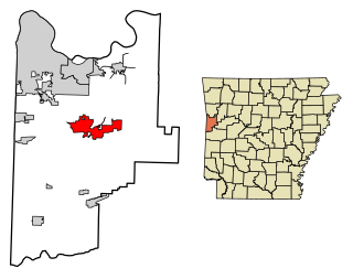
Greenwood is a city in and one of the two county seats of Sebastian County, Arkansas, United States. It is the fifth largest municipality in the Fort Smith, Arkansas-Oklahoma Metropolitan Statistical Area with a population of 8,952 according to the 2010 US Census. According to estimates based on the most recent census, the population of Greenwood in 2018 was 9,397.

Arkansas Highway 10 is an east–west state highway in West Arkansas. The route runs 135.41 miles (217.92 km) from Oklahoma State Highway 120 near Hackett east to Interstate 30 in Little Rock, the state's capitol. The highway serves both the Fort Smith metropolitan area and the Little Rock – North Little Rock – Conway metropolitan area.

U.S. Route 64 is a U.S. highway running from Teec Nos Pos, Arizona east to Nags Head, North Carolina. In the U.S. state of Arkansas, the route runs 246.35 miles (396.46 km) from the Oklahoma border in Fort Smith east to the Tennessee border in Memphis. The route passes through several cities and towns, including Fort Smith, Clarksville, Russellville, Conway, Searcy, and West Memphis. US 64 runs parallel to Interstate 40 until Conway, when I-40 takes a more southerly route.

U.S. Route 67 is a U.S. highway running from Presidio, Texas northeast to Sabula, Iowa. In the U.S. state of Arkansas, the route runs 279.15 miles (449.25 km) from the Texas border in Texarkana northeast to the Missouri border near Corning. The route passes through several cities and towns, including Hope, Benton, Little Rock, Jacksonville, Cabot, Beebe, Walnut Ridge, and Pocahontas.

Highway 14 is an east–west state highway in Arkansas. The route of 227.35 miles (365.88 km) begins at Boat Dock Road near Table Rock Lake and runs east to Mississippi County Route W1020 (CR W1020) at Golden Lake. Segments of the highway are part of two Arkansas Scenic Byways: Sylamore Scenic Byway in the Ozark National Forest and the Crowley's Ridge Parkway atop Crowley's Ridge.

Twelve special routes of U.S. Route 63 currently exist. Arkansas and Missouri each contain five, with two in Iowa. There are also five former routings that have been removed from the system.

Powhatan Historic State Park is a 9.1-acre (3.7 ha) Arkansas state park in Lawrence County, Arkansas in the United States. The park contains the 1888 Powhatan courthouse which served as the home of county government from 1869 to 1968. Today the structure displays items of cultural and historical significance and hosts the park's Visitor Center. The park includes four additional historical buildings and the Arkansas History Commission's Northeast Arkansas Regional Archives. A tour of the historic structures is available. Powhatan served as an important stop for traffic on the Black River until the installation of the Kansas City-Memphis Railwayline two miles north in 1883 significantly decreased the need for river transportation.

The Old Bethel Methodist Church, also known as the Old Bethel School, Church, & Cemetery, is a historic Methodist church, school and cemetery in rural Greene County, Arkansas. It is located on Highway 358,& Greene 712 Road in Paragould, Arkansas. It is a modest single-story wood-frame structure, built in 1901, and standing next to a cemetery established in 1882. The original Bethel Methodist Church was constructed in 1880, a small, onestory, white frame church. In 1900, a storm destroyed this building and in 1901 an almost identical building replaced the original structure. George Russell, a local carpenter, built the building using native materials of cypress and pine. It measures 20 feet by 40 feet and has a high pitched roof covered by tin. Exterior walls are covered with six inch beveled pine siding, while interior walls and ceiling are beaded pine wall board. Adjacent to it is a cemetery that dates to 1886. The first person buried here was Moss Widner in 1882. The building served the small community of Finch as not just a church, but also as a school, and was vacated in 1941. It was restored in the 1970s by a group of local concerned citizens, and is occasionally used for services.

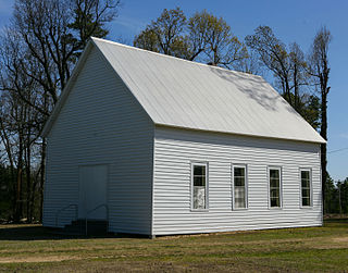
Smyrna Methodist Church is a historic church in rural White County, Arkansas. It is located west of Searcy, on Jaybird Lane just south of Arkansas Highway 36. It is a single story wood-frame structure, with a gabled roof, mainly weatherboard siding, and a stone foundation. A small open belfry rises from the roof ridge, topped by a gabled roof. The front facade has a projecting gabled vestibule, its gabled section finished in diamond-cut wooden shingles. The main gable is partly finished in vertical board siding, with decorative vergeboard woodwork attached to the roof edge.

The Maxie Theatre was a historic movie theatre at 136 Arkansas Highway 463 South in Trumann, Arkansas. It is a single-screen theatre, housed in a large Art Deco structure built in 1948-9 by Zell Jaynes. At the time of its opening it featured the latest in amenities, including air conditioning, upholstered seats, and a fancy curtain to cover the screen. It also had a purpose-built segregated seating area for African-American in the balcony, with separate entrance, ticketing, and concession facilities. Until its closure in 2012 the theatre was one of oldest continuously-operating businesses in Trumann and was the town's only theatre.

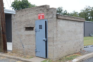
The Beebe Jail is a historic jail building in Beebe, Arkansas. The small single-story concrete structure is set on an alley south of East Illinois Street on the east side of North Main Street. It is distinctive for its slightly rounded concrete roof, with a parapet rising above the front (southwest) facade. The interior has two small cells, each with a barred window, and a small vestibule area. The jail was built as a Works Progress Administration project in 1934.
The Ackins House was a historic house in Floyd, Arkansas. Located on the east side of Arkansas Highway 31 just north of its intersection with Arkansas Highway 305, it was one of the small number of early houses to survive in White County at the time it was listed as a historic site.

The Newport Bridge is a historic cantilevered Warren truss bridge over the White River in Newport, Arkansas. Built in 1930 to carry U.S. Route 67 (US 67), the road it carries is now designated Arkansas Highway 367 (AR 367) after the former highway was relocated. The main bridge is 400 feet (120 m) long, with approaches from the west of 1,278 feet (390 m) and the south of 911 feet (278 m). It has cantilevered arms 138 feet (42 m) long supported by concrete piers, with a suspended Warren truss span of 125 feet (38 m). Designed by Ira G. Hedrick, it is one of three such bridges in the state.

The Tobe Hoofman Farmstead is a historic farm property in rural White County, Arkansas. It is located on the west side of Arkansas Highway 13 north of Judsonia and Arkansas Highway 157. The property includes a farmhouse, wellhouse, barn, and storm cellar on about 40 acres (16 ha) of land. The farmhouse is a vernacular 1+1⁄2-story wood-frame building, with a gable roof and a hip-roof porch with small gables over its access stairs. The wellhouse is a small wood-frame structure with a hip roof; the storm cellar is an earthen structure, mostly below ground, with a small above-ground access building. The barn is a transervse crib wood-frame structure with a gable roof. The farmstead was developed about 1910, and is a little-altered example of an early 20th-century farmstead.

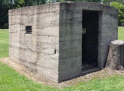
The McRae Jail is a former local jail on East First Street in McRae, Arkansas. It is a small single-story masonry structure, built out of cast concrete. It has a single door with a barred opening, and small openings on the sides, also barred. Built about 1934 with funding from the Works Progress Administration (WPA), it is one of three jails built in White County by the WPA, and is of those three the best preserved.

The Otha Walker Homestead is a historic house on the south side of Arkansas Highway 36, east of the small town of West Point, Arkansas. It is a 1+1⁄2-story double-pile central hall plan structure, topped by a hip roof and clad in novelty siding. A porch extends across the front (north) facade and around the east side, with a shed roof that has exposed rafter ends, and is supported by wooden box columns. The house, built about 1915, is one of the few of this type built in White County between 1914 and 1939.

Highway 51 is a designation for two north–south state highways in Southwest Arkansas. One route of 53.37 miles (85.89 km) begins Highway 53 near Whelen Springs and runs north to US Highway 67 in Donaldson. A second route of 7.92 miles (12.75 km) runs parallel to US 270 northwest of Malvern. Both routes are maintained by the Arkansas Department of Transportation (ArDOT).

Highway 36 is a state highway in Central Arkansas. The highway begins at U.S. Highway 64 (US 64) at Hamlet and runs east through several small communities to Searcy, where it serves as the Beebe-Capps Expressway, a major crosstown arterial roadway. Following a discontinuity at US 64/US 67/US 167, the highway continues east to Kensett as Wilbur D. Mills Avenue before state maintenance ends at the small community of Georgetown. This highway is maintained by the Arkansas Department of Transportation (ARDOT).


