Related Research Articles

The geography of Bolivia includes the Eastern Andes Mountain Range which bisects Bolivia roughly from north to south. To the east of that mountain chain are lowland plains of the Amazon Basin, and to the west is the Altiplano which is a highland plateau where Lake Titicaca is located. Bolivia's geography has features similar to those of Peru which abuts Bolivia's northwest border; like Bolivia, Peru is bisected from north to south by the Eastern Andes Mountains, and these two countries share Lake Titicaca which is the highest navigable lake on Earth. Unlike Peru, however, Bolivia is one of the two landlocked countries in South America, the other being Paraguay which is located along Bolivia's southeast border.

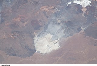
Salar de Uyuni is the world's largest salt flat, or playa, at over 10,000 square kilometres (3,900 sq mi) in area. It is in the Daniel Campos Province in Potosí in southwest Bolivia, near the crest of the Andes at an elevation of 3,656 m (11,995 ft) above sea level.

The Altiplano, Collao or Andean Plateau, in west-central South America, is the most extensive high plateau on Earth outside Tibet. The plateau is located at the latitude of the widest part of the north–south-trending Andes. The bulk of the Altiplano lies in Bolivia, but its northern parts lie in Peru, and its southwestern fringes lie in Chile.

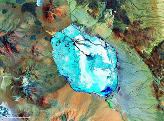
Lake Poopó was a large saline lake in a shallow depression in the Altiplano Mountains in Oruro Department, Bolivia, at an altitude of approximately 3,700 m (12,100 ft). Due to the lake's length and width, it made up the eastern half of Oruro, known as a mining region in southwest Bolivia. The permanent part of the lake body covered approximately 1,000 square kilometres (390 sq mi) and it was the second-largest lake in the country. The lake received most of its water from the Desaguadero River, which flows from Lake Titicaca at the north end of the Altiplano. Since the lake lacked any major outlet and had a mean depth of less than 3 m (10 ft), the surface area differed greatly seasonally.

Laguna Verde is a salt lake in an endorheic basin, in the southwestern Altiplano in Bolivia. It is located in the Sur Lípez Province of the Potosí Department. It is close to the Chilean border, at the foot of the volcano Licancabur.

The Purico complex is a Pleistocene volcanic complex in Chile close to Bolivia, formed by an ignimbrite, several lava domes and stratovolcanoes and one maar. It is in the Chilean segment of the Central Volcanic Zone, one of the four volcanic belts which make up the Andean Volcanic Belt. The Central Volcanic Zone spans Peru, Bolivia, Chile and Argentina and includes 44 active volcanoes as well as the Altiplano–Puna volcanic complex, a system of large calderas and ignimbrites of which Purico is a member. Licancabur to the north, La Pacana southeast and Guayaques to the east are separate volcanic systems.

Salar de Atacama, located 55 km (34 mi) south of San Pedro de Atacama, is the largest salt flat in Chile. It is surrounded by mountains and lacks drainage outlets. To the east, it is enclosed by the main chain of the Andes, while to the west lies a secondary mountain range called Cordillera de Domeyko. The landscape is dominated by imposing volcanoes such as Licancabur, Acamarachi, Aguas Calientes, and Láscar, the latter being one of Chile's most active volcanoes. These volcanoes are situated along the eastern side of the Salar de Atacama, forming a north–south trending line that separates it from smaller endorheic basins.
Pastos Grandes Lake is a lake in the Pastos Grandes caldera in the Potosí Department, Bolivia. At an elevation of 4,430 metres (14,530 ft), its surface area is 120 square kilometres (46 sq mi).

The geology of Bolivia comprises a variety of different lithologies as well as tectonic and sedimentary environments. On a synoptic scale, geological units coincide with topographical units. The country is divided into a mountainous western area affected by the subduction processes in the Pacific and an eastern lowlands of stable platforms and shields. The Bolivian Andes is divided into three main ranges; these are from west to east: the Cordillera Occidental that makes up the border to Chile and host several active volcanoes and geothermal areas, Cordillera Central once extensively mined for silver and tin and the relatively low Cordillera Oriental that rather than being a range by its own is the eastern continuation of the Central Cordillera as a fold and thrust belt. Between the Occidental and Central Cordillera the approximately 3,750-meter-high Altiplano high plateau extends. This basin hosts several freshwater lakes, including Lake Titicaca as well as salt-covered dry lakes that bring testimony of past climate changes and lake cycles. The eastern lowlands and sub-Andean zone in Santa Cruz, Chuquisaca, and Tarija Departments was once an old Paleozoic sedimentary basin that hosts valuable hydrocarbon reserves. Further east close to the border with Brazil lies the Guaporé Shield, made up of stable Precambrian crystalline rock.

Tunupa is a dormant volcano in the Potosí Department of southwestern Bolivia.

Jayu Quta is a maar partially filled with water, in the Bolivian Altiplano, north of the Salar de Uyuni and east of the Salar de Coipasa. It is situated in the Oruro Department, Ladislao Cabrera Province, Salinas de Garci Mendoza Municipality, Villa Esperanza Canton. It was originally misidentified as a meteorite impact crater.

Lake Tauca is a former lake in the Altiplano of Bolivia. It is also known as Lake Pocoyu for its constituent lakes: Lake Poopó, Salar de Coipasa and Salar de Uyuni. The lake covered large parts of the southern Altiplano between the Eastern Cordillera and the Western Cordillera, covering an estimated 48,000 to 80,000 square kilometres of the basins of present-day Lake Poopó and the Salars of Uyuni, Coipasa and adjacent basins. Water levels varied, possibly reaching 3,800 metres (12,500 ft) in altitude. The lake was saline. The lake received water from Lake Titicaca, but whether this contributed most of Tauca's water or only a small amount is controversial; the quantity was sufficient to influence the local climate and depress the underlying terrain with its weight. Diatoms, plants and animals developed in the lake, sometimes forming reef knolls.
Inca Huasi was a paleolake in the Andes. It was named by a research team in 2006.
Ouki was an ancient lake in the Bolivian Altiplano. Its existence was postulated in 2006 by a group of scientists who had subdivided the Lake Minchin lake cycle into several lake phases. The Lake Minchin cycle had been previously identified in 1904 as a now disappeared lake in the central Altiplano. Sediments attributed to Lake Minchin may rather be part of Ouki. The dating is uncertain, with radiocarbon and uranium-thorium dating yielding different dates spanning the time between 28,200 and 125,990 ± 9,580 years ago.
Sajsi is the name of an ancient lake in the Andes
Lake Mataro is an ancient lake in the Andes. It formed over the northern Altiplano at an altitude of 3,950 metres (12,960 ft) and extended over the central Altiplano. It is one of the ancient lakes of the Altiplano like Lake Minchin, Lake Ballivian and Lake Cabana. It existed between 2.8 and 1.8 million years ago.
Lake Ballivián is an ancient lake in the Altiplano of South America and is named after the Bolivian scholar Don Manuel Vicente Ballivian. It is part of a series of lakes which developed in the Titicaca basin along with Lake Mataro and Lake Cabana, reaching an altitude of 3,860 metres (12,660 ft). Lake Ballivián itself is of late Quaternary age and may have influenced the spread and development of animals in the Altiplano. In the southern Altiplano, Lake Escara may be coeval with Lake Ballivián.
Pastos Grandes is the name of a caldera and its crater lake in Bolivia. The caldera is part of the Altiplano-Puna volcanic complex, a large ignimbrite province that is part of the Central Volcanic Zone of the Andes. Pastos Grandes has erupted a number of ignimbrites through its history, some of which exceeded a volume of 1,000 cubic kilometres (240 cu mi). After the ignimbrite phase, the lava domes of the Cerro Chascon-Runtu Jarita complex were erupted close to the caldera and along faults.
Salar de Pajonales is a playa in the southern Atacama Region of Chile and the third-largest in that country, behind Salar de Punta Negra and Salar de Atacama. It consists mostly of a gypsum crust; only a small portion of its area is covered with water. During the late Pleistocene, Salar de Pajonales formed an actual lake that has left shoreline features.
Jay Quade is an American geochemist and geologist. He is known for pioneering research applying geochemical isotopic methods for investigations of tectonics, global climate change, and the paleontology of Darwinian evolution.
References
- 1 2 3 Placzek, Quade & Patchett 2006, p. 523.
- ↑ Placzek, Quade & Patchett 2006, p. 515.
- ↑ Placzek, Quade & Patchett 2013, p. 104.
- ↑ Placzek, Quade & Patchett 2013, p. 106.
- ↑ Luna, Lisa V.; Bookhagen, Bodo; Niedermann, Samuel; Rugel, Georg; Scharf, Andreas; Merchel, Silke (October 2018). "Glacial chronology and production rate cross-calibration of five cosmogenic nuclide and mineral systems from the southern Central Andean Plateau". Earth and Planetary Science Letters. 500: 249. Bibcode:2018E&PSL.500..242L. doi:10.1016/j.epsl.2018.07.034. ISSN 0012-821X. S2CID 134780354.
- ↑ Concha, R.; Úbeda, J.; Iparraguirre, J.; Granados, H.; Vásquez, C.; Estibene, P.; Gomez, W. (November 2022). El registro geomorfológico glaciar de los cambios climáticos en la Cordillera Blanca. Las montañas, nuestro futuro: Simposio Internacional (in Spanish). Arequipa.
- ↑ Cesta, Jason M.; Ward, Dylan J. (November 2016). "Timing and nature of alluvial fan development along the Chajnantor Plateau, northern Chile". Geomorphology. 273: 424. Bibcode:2016Geomo.273..412C. doi: 10.1016/j.geomorph.2016.09.003 . ISSN 0169-555X.
- ↑ Sánchez-Saldías, Andrea; Fariña, Richard A. (March 2014). "Palaeogeographic reconstruction of Minchin palaeolake system, South America: The influence of astronomical forcing". Geoscience Frontiers. 5 (2): 258. doi: 10.1016/j.gsf.2013.06.004 .
- ↑ Placzek, Quade & Patchett 2013, p. 103.
- ↑ Placzek, Quade & Patchett 2011, p. 233.
- ↑ Placzek, Quade & Patchett 2011, p. 239.
Sources
- Placzek, C.; Quade, J.; Patchett, P. J. (8 May 2006). "Geochronology and stratigraphy of late Pleistocene lake cycles on the southern Bolivian Altiplano: Implications for causes of tropical climate change". Geological Society of America Bulletin. 118 (5–6): 515–532. Bibcode:2006GSAB..118..515P. doi:10.1130/B25770.1.
- Placzek, Christa J.; Quade, Jay; Patchett, P. Jonathan (January 2011). "Isotopic tracers of paleohydrologic change in large lakes of the Bolivian Altiplano" (PDF). Quaternary Research. 75 (1): 231–244. Bibcode:2011QuRes..75..231P. doi:10.1016/j.yqres.2010.08.004. S2CID 54069269.
- Placzek, C.J.; Quade, J.; Patchett, P.J. (February 2013). "A 130ka reconstruction of rainfall on the Bolivian Altiplano". Earth and Planetary Science Letters. 363: 97–108. Bibcode:2013E&PSL.363...97P. doi:10.1016/j.epsl.2012.12.017.
Lakes on the Altiplano | |
|---|---|
| Present-day lakes and salt pans | |
| Lake expansions of Lake Titicaca | |
| Ancient lakes | |
| Other paleolakes and lake expansions in the region | |
| Africa | |||||||||||||||||||||||||||||
|---|---|---|---|---|---|---|---|---|---|---|---|---|---|---|---|---|---|---|---|---|---|---|---|---|---|---|---|---|---|
| Antarctica | |||||||||||||||||||||||||||||
| Asia | |||||||||||||||||||||||||||||
| Europe |
| ||||||||||||||||||||||||||||
| North America |
| ||||||||||||||||||||||||||||
| South America | |||||||||||||||||||||||||||||
| Summary | |||||||||||||||||||||||||||||