
Rice County is a county located in the U.S. state of Kansas. As of the 2020 census, the county population was 9,427. The largest city and county seat is Lyons. The county was named in memory of Samuel Allen Rice, Brigadier-General, United States volunteers, killed April 30, 1864, at Jenkins Ferry, Arkansas.

Durham is a city in Marion County, Kansas, United States. As of the 2020 census, the population of the city was 89. The city took its name from Durham cattle. It is located about 8.5 miles north of Hillsboro on the west side of K-15 highway next to a railroad.
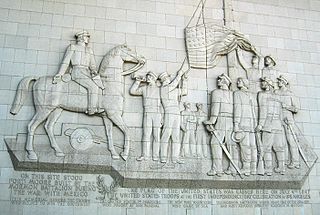
The Mormon Battalion was the only religious unit in United States military history in federal service, recruited solely from one religious body and having a religious title as the unit designation. The volunteers served from July 1846 to July 1847 during the Mexican–American War of 1846–1848. The battalion was a volunteer unit of between 534 and 559 Latter-day Saint men, led by Mormon company officers commanded by regular U.S. Army officers. During its service, the battalion made a grueling march of nearly 2,100 miles from Council Bluffs, Iowa, to San Diego, California.

The Santa Fe Trail was a 19th-century route through central North America that connected Franklin, Missouri, with Santa Fe, New Mexico. Pioneered in 1821 by William Becknell, who departed from the Boonslick region along the Missouri River, the trail served as a vital commercial highway until 1880, when the railroad arrived in Santa Fe. Santa Fe was near the end of El Camino Real de Tierra Adentro, which carried trade from Mexico City.

Fort Union National Monument is a unit of the National Park Service of the United States, and is located north of Watrous in Mora County, New Mexico. The national monument was founded on June 28, 1954.

Fort Kearny was a historic outpost of the United States Army founded in 1848 in the western U.S. during the middle and late 19th century. The fort was named after Col. and later General Stephen Watts Kearny. The outpost was located along the Oregon Trail near Kearney, Nebraska. The town of Kearney took its name from the fort. The "e" was added to Kearny by postmen who consistently misspelled the town name. A portion of the original site is preserved as Fort Kearny State Historical Park by the Nebraska Game and Parks Commission.

Ratón Pass is a 7,834 ft (2,388 m) elevation mountain pass on the Colorado–New Mexico border in the western United States. It is located on the eastern side of the Sangre de Cristo Mountains between Trinidad, Colorado and Raton, New Mexico, approximately 180 miles (290 km) northeast of Santa Fe. Ratón is Spanish for "mouse". The pass crosses the line of volcanic mesas that extends east from the Sangre de Cristo Mountains along the state line, and furnishes the most direct land route between the valley of the Arkansas River to the north and the upper valley of the Canadian River, leading toward Santa Fe, to the south. The pass now carries Interstate 25 and railroad tracks.

Bent's Old Fort is an 1833 fort located in Otero County in southeastern Colorado, United States. A company owned by Charles Bent and William Bent and Ceran St. Vrain built the fort to trade with Southern Cheyenne and Arapaho Plains Indians and trappers for buffalo robes. For much of its 16-year history, the fort was the only major white American permanent settlement on the Santa Fe Trail between Missouri and the Mexican settlements. It was destroyed in 1849.

Pecos National Historical Park is a United States National Historical Park in San Miguel and Santa Fe Counties, New Mexico. The park, operated by the National Park Service, encompasses thousands of acres of landscape infused with historical elements from prehistoric archaeological ruins to 19th-century ranches, to a battlefield of the American Civil War. Its largest single feature is Pecos Pueblo also known as Cicuye Pueblo, a Native American community abandoned in historic times. First a state monument in 1935, it was made Pecos National Monument in 1965, and greatly enlarged and renamed in 1990. Two sites within the park, the pueblo and the Glorieta Pass Battlefield, are National Historic Landmarks.

Cimarron National Grassland is a National Grassland located in Morton County, Kansas, United States, with a very small part extending eastward into Stevens County. Cimarron National Grassland is located near Comanche National Grassland which is across the border in Colorado. The grassland is administered by the Forest Service together with the Pike and San Isabel National Forests and the Comanche National Grassland, from common headquarters located in Pueblo, Colorado. There are local ranger district offices in Elkhart, Kansas. The grassland is the largest area of public land in the state of Kansas.

Wagon Bed Spring, also known historically as the Lower Spring or Lower Cimarron Spring, is a historic former spring in Grant County, Kansas, United States. It is located about 12 miles (19 km) south of Ulysses, on the west side of United States Route 270. In the 19th century it was an important watering spot on the Cimarron Cutoff of the Santa Fe Trail, where migrants on the trail often camped. The spring is now dry, primarily due to irrigation lowering the water table in the area. It was declared a National Historic Landmark in 1961.

Point of Rocks is a cliff in Morton County, Kansas which was one of three landmarks by the same name on the Santa Fe Trail. This one was on the Cimarron Cutoff. It is now part of Cimarron National Grassland.

The Council Grove Historic District is a National Historic Landmark District located in Council Grove, Kansas, United States. It consists of six discontiguous areas in the city important in the history of the Santa Fe Trail and American migration to the west in the 19th century. Council Grove was named for the occasion of an 1825 treaty negotiation between the Osage Indians and the US Federal government which guaranteed the Santa Fe caravans safe passage through Osage territory. The landmark was designated in 1963.

The Santa Fe Trail Remains, also known as Santa Fe Trail Ruts, are a two-mile (3 km) section of the former 1,200-mile (1,900 km) long Santa Fe Trail, described as the "longest continuous stretch of clearly defined Santa Fe Trail rut remains in Kansas." Now owned by a preservation organization, the site is visible from a pull-off area on United States Route 50 near Dodge City, Kansas. The site was declared a National Historic Landmark in 1963.

The Rabbit Ears are a pair of mountain peaks in northeastern New Mexico, United States, 8 kilometres (5.0 mi) north of the city of Clayton. The two peaks were a distinctive landmark along the Cimarron Cutoff of the Santa Fe Trail, a major route for westbound settlers in the 19th century. The formation was designated a National Historic Landmark in 1963.The name is that of a Native American chief who was killed here in a battle with the Spanish in 1717.
Santa Fe Trail – Grand Pass Trail Segments are three historic Santa Fe Trail segments located at Grand Pass, Saline County, Missouri. The three trail rut segments are located within Maple Hill Cemetery and near Grand Pass Methodist Church. They date to 1821–1827.
Santa Fe Trail - Saline County Trail Segments are four historic Santa Fe Trail segments located near Stanhope, Saline County, Missouri. The four trail rut segments are located on the Weinrich farm. They date to 1821–1827.
85th and Manchester "Three Trails" Trail Segment is a historic Santa Fe Trail segment located at Kansas City, Jackson County, Missouri. The segment is a deep and wide swale that diverges around a natural rock outcrop and measures approximately 390 feet (120 m) long. The segment may have been on the route of the original Santa Fe trading expedition led by William Becknell in 1821.
Santa Fe Trail-Rice County Trail Segments are historic sites in Rice County, Kansas which preserve segments of the historic Santa Fe Trail.

Six Mile Creek Stage Station Historic District is the site of a stagecoach station and ranch on the Santa Fe Trail in western Morris County, Kansas. The site is located near the trail's crossing of Six Mile Creek, which was named for its location 6 miles (9.7 km) west of Diamond Spring. After the stagecoach station at Diamond Spring was destroyed, a new station was built at Six Mile Creek in 1863. The station lasted until later in the 1860s, when new railroad construction made the stage line obsolete. Charley Owens began a ranch at the site in 1866, and while his ranch only lasted two years, the site was sporadically used for ranching and farming into the twentieth century. In addition to the ruined stage station, the site includes the remnants of a barn, blacksmith shop, corral, and well, along with several ruts from the trail.


