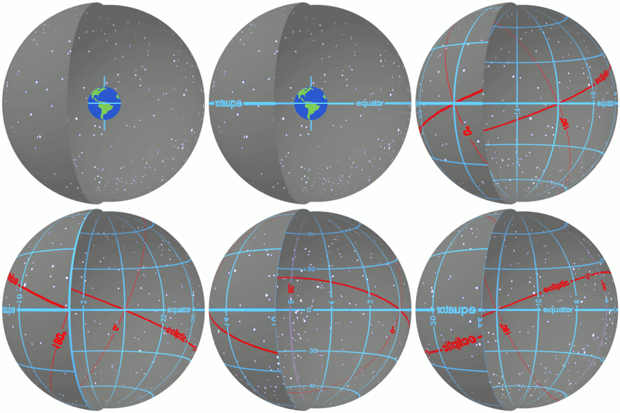
In astronomy, declination is one of the two angles that locate a point on the celestial sphere in the equatorial coordinate system, the other being hour angle. Declination's angle is measured north or south of the celestial equator, along the hour circle passing through the point in question.

In geography, latitude is a geographic coordinate that specifies the north–south position of a point on the Earth's surface. Latitude is an angle which ranges from 0° at the Equator to 90° at the poles. Lines of constant latitude, or parallels, run east–west as circles parallel to the equator. Latitude is used together with longitude to specify the precise location of features on the surface of the Earth. On its own, the term latitude should be taken to be the geodetic latitude as defined below. Briefly, geodetic latitude at a point is the angle formed by the vector perpendicular to the ellipsoidal surface from that point, and the equatorial plane. Also defined are six auxiliary latitudes that are used in special applications.

The Mercator projection is a cylindrical map projection presented by Flemish geographer and cartographer Gerardus Mercator in 1569. It became the standard map projection for navigation because it is unique in representing north as up and south as down everywhere while preserving local directions and shapes. The map is thereby conformal. As a side effect, the Mercator projection inflates the size of objects away from the equator. This inflation is very small near the equator but accelerates with increasing latitude to become infinite at the poles. As a result, landmasses such as Greenland and Antarctica appear far larger than they actually are relative to landmasses near the equator, such as Central Africa.

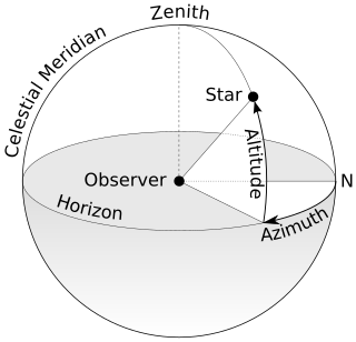
An azimuth is an angular measurement in a spherical coordinate system. The vector from an observer (origin) to a point of interest is projected perpendicularly onto a reference plane; the angle between the projected vector and a reference vector on the reference plane is called the azimuth.

A sundial is a horological device that tells the time of day when there is sunlight by the apparent position of the Sun in the sky. In the narrowest sense of the word, it consists of a flat plate and a gnomon, which casts a shadow onto the dial. As the Sun appears to move across the sky, the shadow aligns with different hour-lines, which are marked on the dial to indicate the time of day. The style is the time-telling edge of the gnomon, though a single point or nodus may be used. The gnomon casts a broad shadow; the shadow of the style shows the time. The gnomon may be a rod, wire, or elaborately decorated metal casting. The style must be parallel to the axis of the Earth's rotation for the sundial to be accurate throughout the year. The style's angle from horizontal is equal to the sundial's geographical latitude.

In astronomy, an analemma is a diagram showing the position of the Sun in the sky as seen from a fixed location on Earth at the same mean solar time, as that position varies over the course of a year. The diagram will resemble a figure eight. Globes of Earth often display an analemma as a two-dimensional figure of equation of time vs. declination of the Sun.

In navigation, a rhumb line, rhumb, or loxodrome is an arc crossing all meridians of longitude at the same angle, that is, a path with constant bearing as measured relative to true north.
The main trigonometric identities between trigonometric functions are proved, using mainly the geometry of the right triangle. For greater and negative angles, see Trigonometric functions.

Analemmatic sundials are a type of horizontal sundial that has a vertical gnomon and hour markers positioned in an elliptical pattern. The gnomon is not fixed and must change position daily to accurately indicate time of day. Hence there are no hour lines on the dial and the time of day is read only on the ellipse. As with most sundials, analemmatic sundials mark solar time rather than clock time.
Polar alignment is the act of aligning the rotational axis of a telescope's equatorial mount or a sundial's gnomon with a celestial pole to parallel Earth's axis.
François-Lamathe Dom Bédos de Celles de Salelles was a Benedictine monk best known for being a master pipe organ builder.

Astronomical rings, also known as Gemma's rings, are an early astronomical instrument. The instrument consists of three rings, representing the celestial equator, declination, and the meridian.

Geodetic coordinates are a type of curvilinear orthogonal coordinate system used in geodesy based on a reference ellipsoid. They include geodetic latitude (north/south) ϕ, longitude (east/west) λ, and ellipsoidal heighth. The triad is also known as Earth ellipsoidal coordinates.

The Whitehurst & Son sundial was produced in Derby in 1812 by the nephew of John Whitehurst. It is a fine example of a precision sundial telling local apparent time with a scale to convert this to local mean time, and is accurate to the nearest minute. The sundial is now housed in the Derby Museum and Art Gallery.

A bifilar dial is a type of sundial invented by the German mathematician Hugo Michnik in 1922. It has two non-touching threads parallel to the dial. Usually the second thread is orthogonal-(perpendicular) to the first. The intersection of the two threads' shadows gives the local apparent time.

Giovanni Francesco Zarbula was a mural painter and sundial designer from Piedmont Italy who created a hundred or more vertical and vertical declining sundials in the French and Italian Alpes between 1830 and 1881. He worked exclusively in Savoy, in Piémont, the Valley of the Ubaye, le Queyras and around Briançon.
Dialing scales are used to lay out the face of a sundial geometrically. They were proposed by Samuel Foster in 1638, and produced by George Serle and Anthony Thompson in 1658 on a ruler. There are two scales: the latitude scale and the hour scale. They can be used to draw all gnomonic dials – and reverse engineer existing dials to discover their original intended location.

A London dial in the broadest sense can mean any sundial that is set for 51°30′ N, but more specifically refers to a engraved brass horizontal sundial with a distinctive design. London dials were originally engraved by scientific instrument makers. The trade was heavily protected by the system of craft guilds.
A schema for horizontal dials is a set of instructions used to construct horizontal sundials using compass and straightedge construction techniques, which were widely used in Europe from the late fifteenth century to the late nineteenth century. The common horizontal sundial is a geometric projection of an equatorial sundial onto a horizontal plane.

Burt's solar compass or astronomical compass is a surveying instrument that makes use of the sun's direction instead of magnetism. William Austin Burt invented his solar compass in 1835. The solar compass works on the principle that the direction to the sun at a specified time can be calculated if the position of the observer on the surface of the Earth is known, to a similar precision. The direction can be described in terms of the angle of the sun relative to the axis of rotation of the planet.


