
Sheridan County is a county in the U.S. state of Wyoming. As of the 2010 United States Census, the population was 29,116. The county seat is Sheridan. Its north boundary line abuts the south line of the state of Montana.

Big Horn is an unincorporated community and census-designated place (CDP) in Sheridan County, Wyoming, United States. The population was 198 at the 2000 census and 490 at the 2010 census.
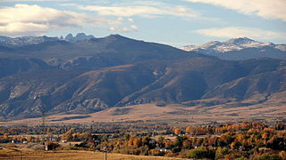
Sheridan is a city in Sheridan County, Wyoming, United States. The 2010 census put the population at 17,444 and a Micropolitan Statistical Area of 29,116. It is the county seat of Sheridan County.
The Sheridan College Institute of Technology and Advanced Learning, previously called Sheridan College of Applied Arts and Technology, commonly known as Sheridan College, is a diploma- and degree-granting polytechnic institute in Ontario, with approximately 23,000 full-time students and 35,000 continuing education students. Founded in 1967, the college offers programs in animation and illustration, music theatre, film and design, business, applied computing, engineering technology, community studies, and liberal studies. There are campuses in Oakville, Brampton, and Mississauga.

Philip Henry Sheridan was a career United States Army officer and a Union general in the American Civil War. His career was noted for his rapid rise to major general and his close association with General-in-chief Ulysses S. Grant, who transferred Sheridan from command of an infantry division in the Western Theater to lead the Cavalry Corps of the Army of the Potomac in the East. In 1864, he defeated Confederate forces under General Jubal Early in the Shenandoah Valley and his destruction of the economic infrastructure of the Valley, called "The Burning" by residents, was one of the first uses of scorched earth tactics in the war. In 1865, his cavalry pursued Gen. Robert E. Lee and was instrumental in forcing his surrender at Appomattox.

The Tongue River is a tributary of the Yellowstone River, approximately 265 mi (426 km) long, in the U.S. states of Wyoming and Montana. The Tongue rises in Wyoming in the Big Horn Mountains, flows through northern Wyoming and southeastern Montana and empties into the Yellowstone River at Miles City, Montana. Most of the course of the river is through the beautiful and varied landscapes of eastern Montana, including the Tongue River Canyon, the Tongue River breaks, the pine hills of southern Montana, and the buttes and grasslands that were formerly the home of vast migratory herds of American bison. The Tongue River watershed encompasses parts of the Cheyenne and Crow Reservations. The Headwaters lie on the Big Horn National Forest, and the watershed encompasses the Ashland Ranger District of the Custer National Forest.

The Bighorn Mountains are a mountain range in northern Wyoming and southern Montana in the United States, forming a northwest-trending spur from the Rocky Mountains extending approximately 200 miles (320 km) northward on the Great Plains. They are separated from the Absaroka Range, which lie on the main branch of the Rockies in western Wyoming, by the Bighorn Basin. Much of the land is contained within the Bighorn National Forest.

The Beaverhead-Deerlodge National Forest is the largest of the National Forests in Montana, United States. Covering 3.36 million acres (13,600 km2), the forest is broken into nine separate sections and stretches across eight counties in the southwestern area of the state. President Theodore Roosevelt named the two forests in 1908 and they were merged in 1996. Forest headquarters are located in Dillon, Montana. In Roosevelt's original legislation, the Deerlodge National Forest was called the Big Hole Forest Reserve. He created this reserve because the Anaconda Copper Mining Company, based in Butte, Montana, had begun to clearcut the upper Big Hole River watershed. The subsequent erosion, exacerbated by smoke pollution from the Anaconda smelter, was devastating the region. Ranchers and conservationists alike complained to Roosevelt, who made several trips to the area. (Munday 2001)
The Bighorn National Forest is a U.S. National Forest located in northern Wyoming, United States and consists of over 1.1 million acres (4,500 km²). Created as a US Forest Reserve in 1897, it is one of the oldest government-protected forest lands in the U.S. The forest is well east of the continental divide and extends from the Montana border for a distance of 80 miles (130 km) along the spine of the Bighorn Mountains, an outlying mountain range separated from the rest of the Rocky Mountains by Bighorn Basin. Elevations range from 5,000 feet along the sagebrush and grass-covered lowlands at the foot of the mountains, to 13,189 feet on top of Cloud Peak, the highest point in the Bighorn Mountains. Around 99% of the land is above 1,500 metres (4,900 ft). The forest is named after the Bighorn River, which is partially fed by streams found in the forest. Streams in the range are fed primarily by snowmelt and snowmelt mixed with driving rainfall.

Sheridan is an 'L' station on the CTA's Red Line. It is an elevated station with two island platforms, located at 3940 North Sheridan Road, in the Lakeview neighborhood of Chicago's Lakeview community area. Sheridan is the closest 'L' stop to Graceland Cemetery, which is about one-half mile to the west on Irving Park Road. The Sheridan station is one of only two remaining 'L' stations that were built on S-curves; Indiana on the Green Line is the other.
Mount Scott is a prominent mountain just to the northwest of Lawton, Oklahoma rising to a height of 2,464 feet (751 m). It is located in the Wichita Mountains near Fort Sill Military Reservation and lies in the Wichita Mountains National Wildlife Refuge (WMWR). The US Fish and Wildlife Service is responsible for the maintenance of the area. Visitors can reach the summit by car or bicycle via a three-mile paved road. Hiking is allowed, although there are no formal trails and the paved road is open to pedestrians and bicycles from 6am to 9:30 am only. Mount Scott is also popular for its numerous rock climbing areas. The peak was named in honor of General Winfield Scott.

KZZS is a radio station broadcasting a Hot Adult Contemporary format. Licensed to Story, Wyoming, United States, the station serves the Sheridan area, along with most of northeastern Wyoming. The station is currently owned by Big Horn Mountain Radio Network, a division of Legend Communications of Wyoming, LLC, and features programming from Westwood One.
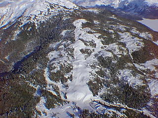
Mount Eyak is a ski area located in Cordova, Alaska. It is operated by the Sheridan Ski Club.

KHRW is a radio station licensed to Ranchester, Wyoming, United States. It serves the Sheridan area, and carries a Classic hits format. The station is currently owned by Legend Communications of Wyoming, LLC.

Buffalo Bill - The Scout, a bronze statue of a mounted rider outside the Buffalo Bill Historical Center in Cody, Wyoming, was placed in 1924 to commemorate the town's most famous resident and de facto founder, Buffalo Bill Cody. Originally in open land on the western outskirts of Cody, the statue today stands at the end of Sheridan Avenue, the town's main thoroughfare, as the town has grown to the west. The project was initiated by Cody's niece, Mary Jester Allen, who had established the basis of what would become the Buffalo Bill Historical Center. A New Yorker, she persuaded heiress and artist Gertrude Vanderbilt Whitney to sculpt the piece.
Mount Everts el. 7,846 feet (2,391 m) is a prominent mountain peak in Yellowstone National Park, Wyoming near Mammoth Hot Springs. The peak was named for Truman C. Everts, a member of the Washburn–Langford–Doane Expedition of 1870. Mount Everts is located immediately due south of Gardiner, Montana and due east of Mammoth Hot Springs.

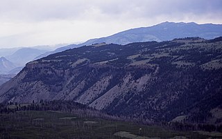
Mount Sheridan el. 10,313 feet (3,143 m) is a prominent mountain peak overlooking Heart Lake in the Red Mountains of Yellowstone National Park. The peak is named in honor of General Philip H. Sheridan, U.S. Army, one of the early protectors of the park.

Sheridan School is an independent, co-ed, progressive, K-8 school in Washington, D.C. The school enrolls about approximately 225 students. The average tuition for the 2018–2019 school year is $36,708. The school awarded $1.3 million in financial aid in 2018–2019. More than one-third (35%) of Sheridan students are students of color.

Mount Sheridan is a suburb of Cairns in the Cairns Region, Queensland, Australia.

Garfield Mountain is a mountain located in the Catskill Mountains of New York south of Allaben. Fork Ridge is located south, Sheridan Mountain is located east-northeast, and Romer Mountain is located southeast of Garfield Mountain.


