
Kennett River is a town in Colac Otway Shire, Victoria, Australia.

Konini is a suburb in West Auckland, New Zealand, under the local governance of Auckland Council.
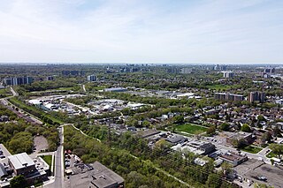
Rockcliffe–Smythe is a neighbourhood in Toronto, Ontario, Canada. It was developed after World War II as part of the urbanization of the former suburb of York Township. It is in Ward 5 in the City of Toronto.

The Shire of Halls Creek is one of the four local government areas in the Kimberley region of northern Western Australia, covering an area of 143,030 square kilometres (55,224 sq mi), most of which is sparsely populated. The Shire's seat of government is the town of Halls Creek. Many Aboriginal communities are located within the shire.

Nerrigundah is a locality and former village in south eastern New South Wales situated at the head of the Tuross River Valley, nineteen kilometres inland from Bodalla. At the 2021 census, the locality had a population of 40.

Smythesdale is a town in Victoria, Australia. The town is located on the Glenelg Highway. Most of the town is located in the Golden Plains Shire local government area. Smythesdale is 19 kilometres (12 mi) west of Ballarat and 135 kilometres (84 mi) west of the state capital, Melbourne. At the 2021 census, Smythesdale and the surrounding area had a population of 1,189. Smythesdale Primary School is a part of the Woady Yaloak PS with Ross Creek, Scarsdale, and Snake Valley as the other campus.

Banks Creek is a rural locality split between the City of Brisbane and Somerset Region in Queensland, Australia. The locality is also split for the purposes of state and federal elections. In the 2021 census, Banks Creek had a population of 11 people.
England Creek is a rural locality split between Somerset Region and City of Brisbane, Queensland, Australia. In the 2021 census, England Creek had a population of 39 people.

Spring Creek is a rural locality split between the Toowoomba Region and the Southern Downs Region, Queensland, Australia. In the 2021 census, Spring Creek had a population of 195 people.
Cattle Creek is a rural locality in the Toowoomba Region, Queensland, Australia. In the 2021 census, Cattle Creek had a population of 21 people.
Rocky Creek is a rural locality in the Toowoomba Region, Queensland, Australia. In the 2021 census, Rocky Creek had a population of 35 people.
Punchs Creek is a rural locality in the Toowoomba Region, Queensland, Australia. In the 2021 census, Punchs Creek had a population of 35 people.
Cherry Creek is a rural locality in the Toowoomba Region, Queensland, Australia. In the 2021 census, Cherry Creek had a population of 38 people.
Googa Creek is a rural locality in the Toowoomba Region, Queensland, Australia. In the 2021 census, Googa Creek had a population of 54 people.
Winter Valley is a western suburb of the City of Ballarat. The population at the 2021 census was 3,440. Established on 11 February 2016 as part of the western growth zone, Winter Valley was named after early colonist John Winter following a controversy on whether on not it should be named after the 19th-century Aboriginal elder Mullawallah.
Bulli Creek is a rural locality in the Toowoomba Region, Queensland, Australia. In the 2021 census, Bulli Creek had "no people or a very low population".
Cressbrook Creek is a rural locality in the Toowoomba Region, Queensland, Australia. In the 2021 census, Cressbrook Creek had a population of 10 people.
Upper Cooyar Creek is a rural locality in the Toowoomba Region, Queensland, Australia. In the 2021 census, Upper Cooyar Creek had a population of 16 people.
Cowley Creek is a rural locality in the Cassowary Coast Region, Queensland, Australia. In the 2021 census, Cowley Creek had "no people or a very low population".
Skenes Creek is a locality in Victoria, Australia, situated in the Shire of Colac Otway. In the 2021 census, Skenes Creek had a population of 249.


