This article is about the geographic parish, former local service district, and rural census subdivision. For the community, see South Esk, New Brunswick.
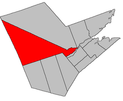
on the east by a line from the middle of the Northwest Miramichi River to the northeastern corner of a grant to Charles Vye Sr., about 700 metres east of Enclosure Road;
on the south by a line beginning at the northeastern corner of the Vye grant, then westerly in a straight line 116 chains (about 2.3 kilometres) to the southeastern line of a grant to Stephen Sherwood at a point about 700 metres slightly east of south of the junction of Route 420 and Creamer Road, then northwesterly to Old Creamer Road, then southwesterly about 600 metres along Old Creamer Road to the southwestern line of a grant to James Oxford, then northwesterly along the Oxford grant to its westernmost corner, then southwesterly and northwesterly along the rear line of grants on the Southwest Miramichi River, then northwesterly and southwesterly to exclude a grant to Jared Betts on the northeastern side of Williamstown Road, then southeasterly along Williamstown Road to rejoin the rear line of Southwest Miramichi River grants, then generally southwesterly along the river grants before turning westerly to exclude several inland grants straddling Route 8 south of Crocker Lake, then southwesterly to Route 8 at the northwest line of the Elm Tree Tract granted to William Davidson, then southwesterly along the Elm Tree Tract and its prolongation to the Blackville Parish line, about 1.8 kilometres northwesterly of Route 8, then northwesterly about 7 kilometres along a line running north 22º west[b] from the mouth of the Renous River, then south 72º west by an astronomic bearing to the York County line;
on the west by the York and Victoria county lines.
Evolution of boundaries
Southesk has had the same western, northern, and eastern boundaries from its creation; the boundary with Derby was a straight line running a line running south 68º west[c] from modern Wilsons Point.[9]
In 1920 the boundary with Derby Parish was changed to run along property and grant lines.[17] The wording was ambiguous enough to require clarification in 1953[18] and 1954.[19] The 1954 Act also changed the wording of the boundary with Blackville, Blissfield, and Ludlow Parishes to run partly by an astronomic rather than a magnetic bearing.
↑By the magnet of 1879,[9] when declination in the area was between 22º and 23º west of north.[12] The Territorial Division Act clause referring to magnetic direction bearings was omitted in the 1952[13] and 1973 Revised Statutes.[2]
↑By the magnet of 1850,[14] when declination in the area was between 20º and 21º west of north.[12]
↑By the magnet of 1814,[15] when declination in the area was between 16º and 17º west of north.[16]
↑The Territorial Division Act[2] divides the province into 152 parishes, the cities of Saint John and Fredericton, and one town of Grand Falls. The Interpretation Act[3] clarifies that parishes include any local government within their borders.
123"42 Vic. c. 37 An Act to erect part of the Parish of Northesk, in the County of Northumberland, into a separate Parish.". Acts of the General Assembly of Her Majesty's Province of New Brunswick. Passed in the Month of April 1879. Fredericton: Government of New Brunswick. 1879. pp.77–78. Available as a free ebook from Google Books.
12345"No. 47". Provincial Archives of New Brunswick. Department of Natural Resources and Energy Development. Retrieved 18 June 2021. Remainder of parish on maps 48, 56–59, 66–69, 75, and 76 at same site.
12345"126"(PDF). Transportation and Infrastructure. Government of New Brunswick. Retrieved 18 June 2021. Remainder of parish on mapbooks 127, 148–150, 166–169, 182–187, 198–204, 213–218, and 228–230 at same site.
↑"Chapter 227 Territorial Division Act". The Revised Statutes of New Brunswick 1952 Volume III. Fredericton: Government of New Brunswick. 1952. pp.3725–3771. Scans of this Act may be requested from the Legislative Library of New Brunswick.
↑"9 Geo. V c. 55 An Act to amend Chapter 2 of the Consolidated Statutes, 1903, respecting the division of the Province into Counties, Towns and Parishes.". Acts of the Legislative Assembly of New Brunswick Passed in the Month of April 1919. Fredericton: Government of New Brunswick. 1919. pp.258–265.
↑"2 Elizabeth II, 1952, c. 81 An Act to Amend the Territorial Division Act". Acts of the Legislature of New Brunswick Passed During the Session of 1953. Fredericton: Government of New Brunswick. 1953. p.202.
↑"3 Elizabeth II, 1954, c. 83 An Act to Amend the Territorial Division Act". Acts of the Legislature of New Brunswick Passed During the Session of 1954. Fredericton: Government of New Brunswick. 1954. pp.189–191.
This page is based on this Wikipedia article Text is available under the CC BY-SA 4.0 license; additional terms may apply. Images, videos and audio are available under their respective licenses.