The Altai Mountains, also spelled Altay Mountains, are a mountain range in Central and East Asia, where Russia, China, Mongolia, and Kazakhstan converge, and where the rivers Irtysh and Ob have their headwaters. The massif merges with the Sayan Mountains in the northeast, and gradually becomes lower in the southeast, where it merges into the high plateau of the Gobi Desert. It spans from about 45° to 52° N and from about 84° to 99° E.

The Sayan Mountains are a mountain range in southern Siberia spanning southeastern Russia and northern Mongolia. Before the rapid expansion of the Tsardom of Russia, the mountain range served as the border between Mongolian and Russian cultures and cultural influences.
An amphibrach is a metrical foot used in Latin and Greek prosody. It consists of a long syllable between two short syllables. The word comes from the Greek ἀμφίβραχυς, amphíbrakhys, "short on both sides".

Mount Blue Sky is the highest peak in the Mount Evans Wilderness in the Front Range of the Rocky Mountains of North America. The prominent 14,266.1-foot (4,348 m) fourteener is located 13.4 miles (21.6 km) southwest by south of Idaho Springs in Clear Creek County, Colorado, United States, on the drainage divide between Clear Creek in Arapaho National Forest and the North Fork South Platte River in Pike National Forest.

The northernmost point of land within the boundaries of Canada is Cape Columbia, Ellesmere Island, Nunavut 83.111°N 69.972°W. The northernmost point of the Canadian mainland is Zenith Point on Boothia Peninsula, Nunavut 72.002°N 94.655°W. The southernmost point is Middle Island, in Lake Erie, Ontario ; the southernmost water point lies just south of the island, on the Ontario–Ohio border (41°40′35″N). The southernmost point of the Canadian mainland is Point Pelee, Ontario 41.909°N 82.509°W. The lowest point is sea level at 0 m, whilst the highest point is Mount Logan, Yukon, at 5,959 m / 19,550 ft 60.567°N 140.405°W.

The Stuart Range is a mountain range in central Washington, United States. The range lies within the eastern extent of the Cascade Range immediately southwest of Leavenworth and runs east–west. The western peaks make up a single sharp ridge. The eastern half of the range splits into two parallel ridges, the northern of which is known as the Enchantment Peaks. Between these ridges lies the Enchantment Basin, which holds the dozens of tarns known as the Enchantment Lakes. Collectively, the basin and the encircling eastern peaks of the Stuart Range make up The Enchantments, a well-known backpacking destination. The south face of the Stuart Range falls off steeply to Ingalls Creek, beyond which rise the roughly parallel Wenatchee Mountains.

The Greater Caucasus is the major mountain range of the Caucasus Mountains. It stretches for about 1,200 kilometres (750 mi) from west-northwest to east-southeast, from the Taman Peninsula of the Black Sea to the Absheron Peninsula of the Caspian Sea: from the Western Caucasus in the vicinity of Sochi on the northeastern shore of the Black Sea and reaching nearly to Baku on the Caspian.

The North Shore Mountains are a mountain range overlooking Vancouver in British Columbia, Canada. Their southernmost peaks are visible from most areas in Vancouver and form a distinctive backdrop for the city.

The geography of the U.S. State of Colorado is diverse, encompassing both rugged mountainous terrain, vast plains, desert lands, desert canyons, and mesas. Colorado is a landlocked U.S. state. In 1861, the United States Congress defined the boundaries of the new Territory of Colorado exclusively by lines of latitude and longitude, stretching from 37°N to 41°N latitude, and from 102°02'48"W to 109°02'48"W longitude. Starting in 1868, official surveys demarcated the boundaries, deviating from the parallels and meridians in several places. Later surveys attempted to correct some of these mistakes but in 1925 the U.S. Supreme Court affirmed that the earlier demarcation was the official boundary. The borders of Colorado are now officially defined by 697 boundary markers connected by straight boundary lines. Colorado, Wyoming, and Utah are the only states that have their borders defined solely by straight boundary lines with no natural features. The southwest corner of Colorado is the Four Corners Monument at 36°59'56"N, 109°2'43"W. This is the only place in the United States where four states meet: Colorado, New Mexico, Arizona, and Utah.

In traditional festive legend and popular culture, Santa Claus's reindeer are said to pull a sleigh through the night sky to help Santa Claus deliver gifts to children on Christmas Eve.
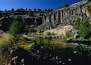
The Donner und Blitzen River is a river on the eastern Oregon high desert that drains a relatively arid basin, the southern portion of Harney Basin, from roughly 20 to 80 miles south-southeast of Burns including Malheur National Wildlife Refuge. Though much of its course is marsh, it offers scenic glaciated canyons, unique ecosystems, and exceptional wild trout fisheries. Named by soldiers of German origin, the Donner und Blitzen River translates as "thunder and lightning". The name usually brings to mind two of Santa Claus's reindeer, but the river is named for a thunderstorm the soldiers experienced as they crossed the river; dry lightning is an almost daily occurrence in the region during certain times of the year.

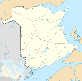
Sugarloaf Mountain is a 281.1 m (922 ft) mountain in the northern Appalachian Mountains in Campbellton, New Brunswick, Canada. The mountain is protected by Sugarloaf Provincial Park and lies within city limits, just south of the urban area.

The Nepisiguit River is a major river in northern New Brunswick, Canada, which enters the sea at the city of Bathurst, into the Nepisiguit Bay, part of the Bay of Chaleur.
"The Strategy of the Were-Wolf Dog" is a short story by Willa Cather. It was first published in Home Monthly in December 1896.

Rudolph the Red-Nosed Reindeer: The Movie is a 1998 American Christmas animated adventure musical film about the character of the same name, who first appeared in a 1939 story by Robert L. May. The film was the first theatrical feature from GoodTimes Entertainment, long known as a home video company. It stars Kathleen Barr as the voice of the titular Rudolph, and also features celebrity voice talents including John Goodman, Eric Idle, Whoopi Goldberg, Debbie Reynolds, Richard Simmons and Bob Newhart. The film disappointed at the box-office, recouping only $113,484 of its $10 million budget from its theatrical release.

Little Blitzen River is a 12.5-mile (20.1 km) tributary of the Donner und Blitzen River in the U.S. state of Oregon. Little Blitzen River rises on the west flank of Steens Mountain about 20 miles (32 km) southeast of Frenchglen and about 70 miles (110 km) south of Burns in Harney County. Flowing west in a steep-walled canyon, it joins the South Fork Donner und Blitzen River at 42.6737752°N 118.7935277°W to form the Donner und Blitzen main stem, which continues north about another 40 miles (64 km) to its mouth at 43.291542°N 118.8199273°W in Malheur Lake. The Donner und Blitzen River was named by soldiers of German origin and translates as "thunder and lightning". Little Blitzen River brings to mind one of Santa Claus's reindeer.
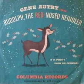
"Rudolph, the Red-Nosed Reindeer" is a song by songwriter Johnny Marks based on the 1939 story Rudolph the Red-Nosed Reindeer published by the Montgomery Ward Company. Gene Autry's recording hit No. 1 on the U.S. charts the week of Christmas 1949.
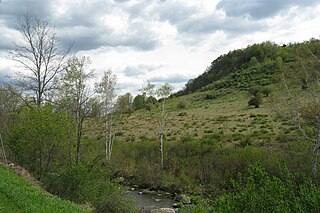
The Hop Brook Valley is a valley in southeastern Berkshire County, Massachusetts. The valley lies predominantly in the town of Tyringham, Massachusetts, although a good portion of it is located in the neighboring town of Lee. Because of its rural location, scenic views, and variety of hiking trails, it is considered as a destination for travellers of the region.

Ice Age: A Mammoth Christmas is a 2011 animated television special and part of the Ice Age franchise, produced by Blue Sky Studios and directed by Karen Disher. It premiered on November 24, 2011 on Fox in the United States and in the United Kingdom at Christmas on Channel 4 and E4 and it was released 2 days later to DVD and Blu-ray. This Christmas special takes place between Ice Age: Dawn of the Dinosaurs and Ice Age: Continental Drift.
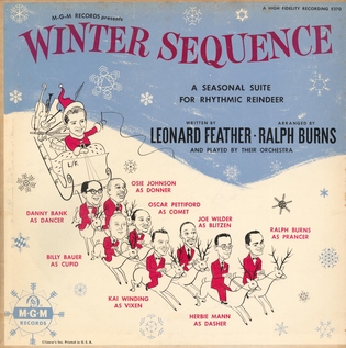
Winter Sequence is a 1954 Christmas jazz album from American pianist Ralph Burns and British music critic Leonard Feather with an ad hoc ensemble of musicians, released on MGM Records.

