Stanley Parish, New Brunswick

Last updated

Stanley
Stanley NB.JPG
York County NB - Stanley Parish.PNG
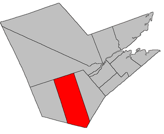
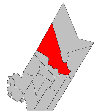
Location within York County, New Brunswick.
Coordinates: 46°29′51″N66°42′36″W / 46.4975°N 66.71°W / 46.4975; -66.71
Country Flag of Canada (Pantone).svg  Canada
Province Flag of New Brunswick.svg  New Brunswick
County York
Erected1837
Dissolved1838
Reërected1847
Area
[1]
  Land1,218.38 km2 (470.42 sq mi)
Population
 (2021) [1]
  Total920
  Density0.8/km2 (2/sq mi)
  Change 2016-2021
Increase2.svg 10.6%
  Dwellings
433
Time zone UTC-4 (AST)
  Summer (DST) UTC-3 (ADT)
Figures do not include portions within the village of Stanley and the rural community of Upper Miramichi

Stanley is a geographic parish in York County, New Brunswick, Canada. [2]

Contents

Prior to the 2023 governance reform, for governance purposes it was divided between the village of Stanley, the incorporated rural community of Upper Miramichi, [3] and the local service district of the parish of Stanley. [4] Upper Miramichi was a member of the Greater Miramichi Regional Service Commission (GMRSC), [5] the others of Capital Region Service Commission (RSC11). [5]

Origin of name

The parish takes its name from the settlement of Stanley, in turn named for Lord Stanley, [6] Secretary of State for War and the Colonies at the time and an early supporter of the New Brunswick and Nova Scotia Land Company that promoted settlement of the area.

History

The first iteration of Stanley was erected in 1837 from Douglas and Saint Marys Parishes. [7]

In 1838 Stanley was dissolved. [8]

In 1847 the modern Stanley was erected from Douglas and Saint Marys, [9] expanding to include the northern part of the county.

Boundaries

Stanley Parish is bounded: [2] [10] [11]

Communities

Communities at least partly within the parish. [10] [11] [17] bold indicates an incorporated municipality or incorporated rural community; italics indicate a name no longer in official use

Bodies of water

Bodies of water [lower-alpha 4] at least partly within the parish. [10] [11] [17]

Islands

Islands at least partly within the parish. [10] [11] [17]

Other notable places

Parks, historic sites, and other noteworthy places at least partly within the parish. [10] [11] [17] [18] [19]

Demographics

Parish population total does not include village of Stanley and portion within Upper Miramichi

See also

Notes

  1. Mapbook 328 erroneously includes the Drummond grant with Stanley Parish, but cadastral map No. 104 has the correct boundary, as confirmed by Drummond's inclusion in the list of grantees for the Campbell grant. [12]
  2. Both cadastral map No. 114 and mapbook 328 show the Casey grant being part of Saint Marys, although Casey wasn't part of either Loyalist group grant along the Nashwaak. The Casey grant was made in 1811, [13] more than twenty years before Stanley Parish was first erected to encompass the lands of the New Brunswick and Nova Scotia Land Company.
  3. By the magnet of 1846, [14] when declination in the area was slightly more than 18º west of north. [15] The Territorial Division Act clause referring to magnetic direction bearings was omitted in the 1952 [16] and 1973 Revised Statutes. [2]
  4. Not including brooks, ponds or coves.

Related Research Articles

<span class="mw-page-title-main">Aberdeen Parish, New Brunswick</span> Parish in New Brunswick, Canada

Aberdeen is a geographic parish in Carleton County, New Brunswick, Canada, located in the interior east of the Saint John River.

<span class="mw-page-title-main">Queensbury Parish, New Brunswick</span> Parish in New Brunswick, Canada

Queensbury is a geographic parish in York County, New Brunswick, Canada.

<span class="mw-page-title-main">Blissfield Parish, New Brunswick</span> Parish in New Brunswick, Canada

Blissfield is a geographic parish in Northumberland County, New Brunswick, Canada.

<span class="mw-page-title-main">Dumfries Parish, New Brunswick</span> Parish in New Brunswick, Canada

Dumfries is a geographic parish in York County, New Brunswick, Canada.

<span class="mw-page-title-main">Hampstead Parish, New Brunswick</span> Parish in New Brunswick, Canada

Hampstead is a geographic parish in Queens County, New Brunswick, Canada.

<span class="mw-page-title-main">Hardwicke Parish, New Brunswick</span> Parish in New Brunswick, Canada

Hardwicke is a geographic parish in Northumberland County, New Brunswick, Canada.

<span class="mw-page-title-main">Ludlow Parish, New Brunswick</span> Parish in New Brunswick, Canada

Ludlow is a geographic parish in Northumberland County, New Brunswick, Canada.

<span class="mw-page-title-main">Newcastle Parish, New Brunswick</span> Parish in New Brunswick, Canada

Newcastle is a geographic parish in Northumberland County, New Brunswick, Canada.

<span class="mw-page-title-main">Northesk Parish, New Brunswick</span> Parish in New Brunswick, Canada

Northesk is a geographic parish in Northumberland County, New Brunswick, Canada.

<span class="mw-page-title-main">Chatham Parish, New Brunswick</span> Parish in New Brunswick, Canada

Chatham is a geographic parish in Northumberland County, New Brunswick, Canada.

<span class="mw-page-title-main">Southesk Parish, New Brunswick</span> Parish in New Brunswick, Canada

Southesk is a geographic parish in Northumberland County, New Brunswick, Canada.

<span class="mw-page-title-main">Derby Parish, New Brunswick</span> Parish in New Brunswick, Canada

Derby is a geographic parish in Northumberland County, New Brunswick, Canada.

<span class="mw-page-title-main">Nelson Parish, New Brunswick</span> Parish in New Brunswick, Canada

Nelson is a geographic parish in Northumberland County, New Brunswick, Canada.

<span class="mw-page-title-main">Glenelg Parish, New Brunswick</span> Parish in New Brunswick, Canada

Glenelg is a geographic parish in Northumberland County, New Brunswick, Canada.

<span class="mw-page-title-main">Blackville Parish, New Brunswick</span> Parish in New Brunswick, Canada

Blackville is a geographic parish in Northumberland County, New Brunswick, Canada.

<span class="mw-page-title-main">Drummond Parish, New Brunswick</span> Parish in New Brunswick, Canada

Drummond is a geographic parish in Victoria County, New Brunswick, Canada.

<span class="mw-page-title-main">Harcourt Parish, New Brunswick</span> Parish in New Brunswick, Canada

Harcourt is a geographic parish in Kent County, New Brunswick, Canada.

<span class="mw-page-title-main">Prince William Parish, New Brunswick</span> Parish in New Brunswick, Canada

Prince William is a geographic parish in York County, New Brunswick, Canada.

<span class="mw-page-title-main">Douglas Parish, New Brunswick</span> Parish in New Brunswick, Canada

Douglas is a geographic parish in York County, New Brunswick, Canada.

<span class="mw-page-title-main">Saint Marys Parish, New Brunswick</span> Parish in New Brunswick, Canada

Saint Marys is a geographic parish in York County, New Brunswick, Canada.

References

  1. 1 2 "Census Profile". Statistics Canada. 26 October 2022. Retrieved 30 October 2022.
  2. 1 2 3 "Chapter T-3 Territorial Division Act". Government of New Brunswick. Retrieved 13 November 2020.
  3. "New Brunswick Regulation 2008-37 under the Municipalities Act (O.C. 2008-110)". Government of New Brunswick. Retrieved 25 July 2020.
  4. "New Brunswick Regulation 84-168 under the Municipalities Act (O.C. 84-582)". Government of New Brunswick. Retrieved 25 July 2020.
  5. 1 2 "Communities in each of the 12 Regional Service Commissions (RSC) / Les communautés dans chacune des 12 Commissions de services régionaux (CSR)" (PDF), Government of New Brunswick, July 2017, retrieved 2 February 2021
  6. Ganong, William F. (1896). A Monograph of the Place-Nomenclature of the Province of New Brunswick. Royal Society of Canada. p. 274. Retrieved 17 March 2021.
  7. "7 Wm. IV c. 25 An Act for erecting a part of the Parishes of Saint Mary's and Douglas in the County of York, into a separate and distinct Town or Parish.". Acts of the General Assembly of His Majesty's Province of New Brunswick, Passed in the Year 1837. Fredericton: Government of New Brunswick. 1837. pp. 82–83. Retrieved 27 March 2021.
  8. "1 Vic. c. 34 An Act to repeal an Act, intituled 'An Act for erecting a part of the Parishes of Saint Mary's and Douglas in the County of York, into a separate and distinct Town or Parish.'". Acts of the General Assembly of Her Majesty's Province of New Brunswick, Passed in the Year 1838. Fredericton: Government of New Brunswick. 1838. pp. 77–78. Retrieved 27 March 2021.
  9. "9 Vic. c. 38 An Act for erecting a part of the Parishes of Saint Mary's and Douglas, in the County of York, into a separate and distinct Town or Parish.". Acts of the General Assembly of Her Majesty's Province of New Brunswick, Passed in the Year 1846. Fredericton: Government of New Brunswick. 1846. pp. 41–42. Retrieved 27 March 2021.
  10. 1 2 3 4 5 "No. 66". Provincial Archives of New Brunswick. Department of Natural Resources and Energy Development. Retrieved 25 June 2021. Remainder of parish on maps 74, 75, 83–85, 93–96, 104, 105, and 114 at same site.
  11. 1 2 3 4 5 "198" (PDF). Transportation and Infrastructure. Government of New Brunswick. Retrieved 25 June 2021. Remainder of parish on mapbooks 212, 213, 227, 228, 243–245, 259–261, 275–279, 291–295, 308–310, and 328 at same site.
  12. "Grant number 11, Index to New Brunswick Land Grants, 1784 - 1997 (RS686)". Provincial Archives of New Brunswick. Retrieved 9 May 2021.
  13. "Crown Grant Reference Map Viewer". Government of New Brunswick. Retrieved 9 May 2021.
  14. "9 Vic. c. 38 An Act for erecting a part of the Parishes of Saint Mary's and Douglas, in the County of York, into a separate and distinct Town or Parish.". Acts of the General Assembly of Her Majesty's Province of New Brunswick, Passed in the Year 1846. Fredericton: Government of New Brunswick. 1846. pp. 41–42. Retrieved 27 March 2021.
  15. "Historical Magnetic Declination". National Oceanic and Atmospheric Administration. Retrieved 9 May 2021.
  16. "Chapter 227 Territorial Division Act". The Revised Statutes of New Brunswick 1952 Volume III. Fredericton: Government of New Brunswick. 1952. pp. 3725–3771.
  17. 1 2 3 4 "Search the Canadian Geographical Names Database (CGNDB)". Government of Canada. Retrieved 3 July 2021.
  18. "New Brunswick Regulation 94-43 under the Fish and Wildlife Act (O.C. 94-231)". Government of New Brunswick. 5 June 2006. Retrieved 8 July 2021.
  19. "Explore New Brunswick's Protected Natural Areas". GeoNB. Retrieved 3 July 2021.
  20. Statistics Canada: 1996, 2001, 2006 census
  21. 2011 Statistics Canada Census Profile: Stanley Parish, New Brunswick
  22. 1 2 "Census Profile, 2016 Census: Stanley, Parish [Census subdivision], New Brunswick". Statistics Canada. Retrieved 28 August 2019.


46°29′51″N66°42′36″W / 46.49750°N 66.71000°W / 46.49750; -66.71000 (Stanley Parish, New Brunswick)