Oakland is the academic and healthcare center of Pittsburgh and one of the city's major cultural centers. Home to three universities, museums, hospitals, shopping venues, restaurants, and recreational activities, this section of the city also includes two city-designated historic districts: the mostly residential Schenley Farms Historic District and the predominantly institutional Oakland Civic Center Historic District, as well as the locally-designated Oakland Square Historic District.
The Hill District is a grouping of historically African American neighborhoods in the City of Pittsburgh, Pennsylvania. Beginning in the years leading up to World War I, "the Hill" was the cultural center of black life in the city and a major center of jazz. Despite its cultural and economic vibrancy, in the mid-1950s a substantial area was slated for redevelopment, displacing about 8,000 individuals.

Homewood is a predominantly African-American neighborhood of Pittsburgh, Pennsylvania, United States, officially divided into three neighborhoods: Homewood North, Homewood South and Homewood West.

Garfield is a neighborhood in the East End of the City of Pittsburgh, Pennsylvania, United States. Garfield is bordered on the South by Bloomfield and Friendship, on the West by the Allegheny Cemetery, on the North by Stanton Heights, and on the East by East Liberty. Like many parts of Pittsburgh, Garfield is a fairly steep neighborhood, with north-south residential streets running at about a 20% incline from Penn Avenue at the bottom to Mossfield Street at the top. Garfield is divided into “the valley” and “the hilltop.”

Arlington Heights is a neighborhood in the southern portion of Pittsburgh, Pennsylvania. The zip code used by residents is 15210, and this neighborhood is represented on the Pittsburgh City Council by the council member for District 3. This neighborhood is home to five government housing projects.

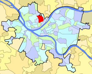
California-Kirkbride is a neighborhood on Pittsburgh, Pennsylvania's North Side.

Beechview is a neighborhood in Pittsburgh, Pennsylvania's southwestern side. It has a zip code of 15216, and has representation on Pittsburgh City Council by both the council member for District 4 and for District 2. Beechview was founded in 1905 after the introduction of a comprehensive light rail transit system. It is Pittsburgh Fire Bureau Zone 4-10 and houses Engine Company #28. It is located in Zone 6 for Pittsburgh Police. While Beechview took an economic downturn in the late 20th century, its proximity to downtown Pittsburgh, convenient access to light rail transit, sweeping vistas and new businesses have allowed Beechview to stabilize economically.
Beltzhoover is a neighborhood in southern Pittsburgh, Pennsylvania, in an area known as the South Hills.

Central Lawrenceville is a neighborhood in the northeast of Pittsburgh, Pennsylvania in the United States. It has a zip code of 15201, and has representation on Pittsburgh City Council by the council member for District 7. It is home to Allegheny Cemetery. Central Lawrenceville is the home of the Pittsburgh Bureau of Fire's 6 Engine and 6 Truck.

Fairywood is a neighborhood on Pittsburgh, Pennsylvania's West End. It has a zip code of 15205, and has representation on Pittsburgh City Council by the council member for District 2. It is the westernmost neighborhood in the City of Pittsburgh.

Glen Hazel is a neighborhood in Pittsburgh, Pennsylvania's east city area. It has both zip codes of 15207 and 15217. It is represented on the Pittsburgh City Council by Corey O'Connor. The neighborhood is located on a hilltop along the Monongahela River and primarily consists of a public housing development of the same name, along with a county-owned nursing home.

Lawrenceville is one of the largest neighborhood areas in Pittsburgh in the U.S. state of Pennsylvania. It is located northeast of downtown, and like many of the city's riverfront neighborhoods, it has an industrial past. The city officially divides Lawrenceville into three neighborhoods, Upper Lawrenceville, Central Lawrenceville, and Lower Lawrenceville, but these distinctions have little practical effect. Accordingly, Lawrenceville is almost universally treated as a single large neighborhood.

Marshall-Shadeland is a neighborhood on Pittsburgh, Pennsylvania's North Side. It has a zip codes of both 15212 and 15214, and has representation on Pittsburgh City Council by the council member for District 1.

Northview Heights is a neighborhood in the North Side of the city of Pittsburgh, Pennsylvania, USA. It has a zip codes of both 15212 and 15214, and has representation on Pittsburgh City Council by the council member for District 1.

Spring Garden is a small neighborhood on Pittsburgh, Pennsylvania's North Side. It takes its name from Spring Garden Avenue, which follows the floor of the valley that separates the two adjacent hilltop neighborhoods of Spring Hill and Troy Hill. Like those neighborhoods, Spring Garden was initially settled by the descendants of Germans and Austrians who had emigrated from Europe to East Allegheny in Allegheny City. These initial residents of Spring Garden worked in slaughterhouses, rendering factories, and tanneries located in this valley neighborhood.

Stanton Heights is a neighborhood in Pittsburgh, Pennsylvania's East End. It has zip codes of both 15201 and 15206, and has representation on Pittsburgh City Council by the council member for District 7. Stanton Heights is the home of PBF 7 Engine and the city's Arson Investigation Units, and is covered by PBP Zone 5 and the Bureau of EMS Medic 6.

Summer Hill is a neighborhood on Pittsburgh, Pennsylvania's North Side. It has a zip code of 15214, and has representation on Pittsburgh City Council by the council member for District 1.

Perry North is a neighborhood in Pittsburgh, Pennsylvania, USA's north city area. It lies within zip codes 15212 and 15214, and has representation on Pittsburgh City Council by the council member for District 1. The highest elevation in Pittsburgh is 1,370 feet at the Brashear Reservoir at the top of Observatory Hill. The Pittsburgh Bureau of fire houses 34 Engine in Perry North.

Perry South—also known as Perry Hilltop—is a neighborhood on Pittsburgh, Pennsylvania's North Side. It developed as a streetcar suburb around the turn of the 20th century, so it consists almost exclusively of residential housing, with a small business district at the intersection of Perrysville Avenue and Charles Avenue. The hill on which the neighborhood is built provides natural borders to the west, to the east and to the south.
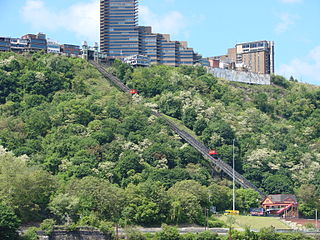
Mount Washington is a neighborhood in Pittsburgh, Pennsylvania's south city area. It has a Zip Code of 15211 and has representation on Pittsburgh City Council by both the council members for District 3 and District 2.