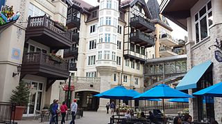
Vail is a Home Rule Municipality in Eagle County, Colorado, United States. The population of the town was 5,305 in 2010. The town, home to Vail Ski Resort, the largest ski mountain in Colorado, is known for its hotels, dining, and for the numerous events the city hosts annually, such as the Vail Film Festival, Burton US Open, Vail Resorts Snow Days, and Bravo! Vail.

The Continental Divide National Scenic Trail is a United States National Scenic Trail running 3,100 miles (5,000 km) between Mexico and Canada. It follows the Continental Divide of the Americas along the Rocky Mountains and traverses five U.S. states — Montana, Idaho, Wyoming, Colorado, and New Mexico. In Montana it crosses Triple Divide Pass The trail is a combination of dedicated trails and small roads and considered 70% complete. Portions designated as uncompleted must be traveled by roadwalking on dirt or paved roads. This trail can be continued north into Canada to Kakwa Lake north of Jasper National Park by the Great Divide Trail.

The Sangre de Cristo Mountains are the southernmost subrange of the Rocky Mountains. They are located in southern Colorado and northern New Mexico in the United States. The mountains run from Poncha Pass in South-Central Colorado, trending southeast and south, ending at Glorieta Pass, southeast of Santa Fe, New Mexico. The mountains contain a number of fourteen thousand foot peaks in the Colorado portion, as well as all the peaks in New Mexico which are over thirteen thousand feet.

Grays Peak is the tenth-highest summit of the Rocky Mountains of North America and the U.S. state of Colorado. The prominent 14,278-foot (4352 m) fourteener is the highest summit of the Front Range and the highest point on the Continental Divide in North America. Grays Peak is located in Arapahoe National Forest, 3.9 miles (6.2 km) southeast by east of Loveland Pass on the Continental Divide between Clear Creek and Summit counties. The peak is the highest point in both counties.

Torreys Peak is a mountain in the Front Range region of the Rocky Mountains in Colorado. It is one of 53 fourteeners in Colorado. Its nearest major city is Denver. Torreys Peak is located along the Continental Divide, as well as the division between Clear Creek County and Summit County.

Argentine Peak is a high mountain summit in the Front Range of the Rocky Mountains of North America. The 13,743-foot (4,189 m) thirteener is located in Arapaho National Forest, 8.5 miles (13.6 km) southwest by south of Georgetown, Colorado, United States. The summit lies on the Continental Divide between Clear Creek and Summit counties.

Red Mountain is a set of three peaks in the San Juan Mountains of western Colorado in the United States, about 5 miles south of Ouray. The mountains get their name from the reddish iron ore rocks that cover the surface. Several other peaks in the San Juan Mountains likewise have prominent reddish coloration from iron ore and are also called "Red Mountain".

Mount Ouray is a high and prominent mountain summit in the far southern Sawatch Range of the Rocky Mountains of North America. The 13,961-foot (4255.4 m) thirteener is located in San Isabel National Forest, 7.5 miles (12.0 km) west of Poncha Pass, Colorado, United States, on the boundary between Chaffee and Saguache counties. The mountain was named in honor of Ute Chief Ouray.
Ouray Peak, elevation 12,963 ft (3,951 m), is a summit in the Sawatch Mountains of Colorado. The peak is 6 mi (9.7 km) south of Independence Pass in the Collegiate Peaks Wilderness of San Isabel National Forest.

The Indian Pass Wilderness is 32,418-acre (13,119 ha) wilderness area under the administered by the Bureau of Land Management. The reserve is located in the very southeastern part of the Chocolate Mountains, in the southeastern part of California, just to the west of the Colorado River in the Lower Colorado River Valley. It adjoins the Picacho Peak Wilderness to the south, and the Imperial National Wildlife Refuge to the east.

Treasure Mountain, elevation 13,535 ft (4,125 m), is a summit in the Elk Mountains of western Colorado. The mountain is in the Raggeds Wilderness southeast of Marble. The massif has been the site of marble mining and a legend of lost French gold.

Grizzly Peak is a high mountain summit in the Front Range of the Rocky Mountains of North America. Also known as Grizzly Peak D, the 13,433-foot (4,094 m) thirteener is located in Arapaho National Forest, 2.1 miles (3.4 km) southeast by east of Loveland Pass, Colorado, United States, on the Continental Divide between Clear Creek and Summit counties. Its proximate parent peak is Torreys Peak.

Specimen Mountain, elevation 12,494 ft (3,808 m), is a summit in the Front Range of northern Colorado. The mountain is north of Milner Pass in Rocky Mountain National Park.
Casco Peak is a high mountain summit in the Sawatch Range of the Rocky Mountains of North America. The 13,915-foot (4,241 m) thirteener is located on the Elbert Massif in San Isabel National Forest, 3.8 miles (6.1 km) east of Independence Pass in Lake County, Colorado, United States.
Iron Mountain is a prominent mountain summit in the southern Sangre de Cristo Range of the Rocky Mountains of North America. The 11,416-foot (3,480 m) peak is located 3.9 miles (6.2 km) west-northwest of the North La Veta Pass, Colorado, United States, on the drainage divide between Costilla and Huerfano counties.

Iron Mountain is a mountain summit in the Never Summer Mountains of the Rocky Mountains of North America. The 12,270-foot (3,740 m) peak is located 2.4 miles (3.8 km) east-southeast of the Cameron Pass, Colorado, United States, on the drainage divide separating State Forest State Park and Jackson County from Roosevelt National Forest and Larimer County.
Garfield Peak is a high mountain summit of the Collegiate Peaks in the Sawatch Range of the Rocky Mountains of North America. The 13,787-foot (4,202 m) thirteener is located 5.6 miles (9.0 km) south-southwest of Independence Pass, Colorado, United States, on the Continental Divide separating San Isabel National Forest and Chaffee County from White River National Forest and Pitkin County. Garfield Peak was named in honor of James A. Garfield, 20th President of the United States.