
Mount Munday is one of the principal summits of the Pacific Ranges of the Coast Mountains in British Columbia, Canada. It is 3,356 m (11,010 ft) in elevation and stands in the Waddington Range six kilometres southeast of Mount Waddington 4,019 m (13,186 ft), which is the highest summit in the Coast Mountains.
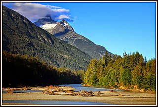
Nusatsum Mountain, is a mountain in the Pacific Ranges of the Coast Mountains of British Columbia, Canada, located near the Nusatsum River and south of and between the communities of Firvale and Hagensborg. The peak can be seen from Highway 20. The mountain is the equivalent of Mount Ararat in the traditions of the Nuxalk, as the place where survivors found refuge from the Great Flood. The landform's toponym was officially adopted March 13, 1947, by the Geographical Names Board of Canada. Other spellings of Nusatsum seen on older maps include "Nootsatsum", "Noosatum" and "Nutsatsum".

Defiance Mountain is a 2,659-metre-elevation (8,724-foot) summit in the northernmost Pacific Ranges of the Coast Mountains of British Columbia, Canada. It is located to the south of the Bella Coola River between the communities of Firvale and Hagensborg. Nusatsum Mountain is to its northwest and Stupendous Mountain to the northeast. The peak can be seen from Highway 20. The landform's toponym was officially adopted March 13, 1947, by the Geographical Names Board of Canada.

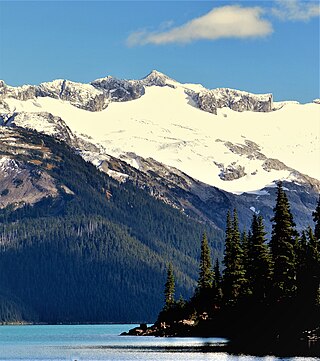
Mount Weart is a 2,835-metre (9,301-foot) triple-summit mountain located in the Garibaldi Ranges of the Coast Mountains, in northwestern Garibaldi Provincial Park of southwestern British Columbia, Canada. It is situated 14 km (9 mi) northeast of Whistler, and its nearest higher peak is Wedge Mountain, 3.7 km (2 mi) to the south, which is the only peak within the park higher than Weart. The Armchair Glacier rests below the west aspect of the summit, and the massive Weart Glacier spans the northern and eastern aspects of the mountain. Precipitation runoff from the peak and meltwater from the glaciers drains into Wedgemount Lake and tributaries of the Lillooet River.
Overlord Mountain is a 2,625-metre (8,612-foot) glacier-clad peak located in the Garibaldi Ranges of the Coast Mountains, in Garibaldi Provincial Park of southwestern British Columbia, Canada. It is the highest point of the Fitzsimmons Range, which is a subset of the Garibaldi Ranges, and can be readily seen from the Whistler Blackcomb ski area. It is situated 15 km (9 mi) southeast of Whistler, and its nearest higher peak is Mount Macbeth, 3 km (2 mi) to the north-northeast. The Benvolio Glacier rests below the south aspect of the summit, the Fitzsimmons Glacier on the east aspect, and the expansive Overlord Glacier spans the northern and western aspects of the mountain. Precipitation runoff from the peak and meltwater from its glaciers drains into tributaries of the Cheakamus River. The first ascent of the mountain was made in 1923 by Phyllis Munday and Don Munday via the Benvolio Glacier. The mountain's descriptive name was recommended by the Garibaldi Park Board and officially adopted on September 2, 1930, by the Geographical Names Board of Canada.

Mount Benvolio is a 2,613-metre (8,573-foot) glacier-clad peak located in the Garibaldi Ranges of the Coast Mountains, in Garibaldi Provincial Park of southwestern British Columbia, Canada. It is the second-highest point of the Fitzsimmons Range, which is a subset of the Garibaldi Ranges. It is situated 15 km (9 mi) southeast of Whistler, and its nearest higher peak is Overlord Mountain, 0.7 km (0 mi) to the northwest. The Benvolio Glacier is set on the western slope of the peak, the Diavolo Glacier spreads out below the eastern aspect of the summit, and the Fitzsimmons Glacier descends the north slope. Precipitation runoff from the peak and meltwater from its glaciers drains into tributaries of the Cheakamus River.

Tremor Mountain is a prominent 2,691-metre (8,829-foot) summit located in the Garibaldi Ranges of the Coast Mountains, in Garibaldi Provincial Park of southwestern British Columbia, Canada. It is the highest point of the Spearhead Range, which is a subset of the Garibaldi Ranges. It is situated 13 km (8 mi) southeast of Whistler, and 8.7 km (5 mi) south of Wedge Mountain, its nearest higher peak. Precipitation runoff from the south side of the peak as well as meltwater from the Platform Glacier drains into Fitzsimmons Creek which is a tributary of the Green River. Meltwater from the Tremor Glacier on the northwestern slope drains to Wedge Creek, and meltwater from the Shudder Glacier on the northeast slope drains into Billygoat Creek, a tributary of the Lillooet River. Tremor Mountain is often climbed as part of the Spearhead Traverse. The first ascent of the mountain was made in 1928 by A.J. Campbell Garibaldi survey party. The mountain's name origin refers to unexplained earth tremors when the first ascent party was on the summit. The mountain's toponym was officially adopted on September 6, 1951, by the Geographical Names Board of Canada.
Mount Tinniswood is a 2,606-metre (8,550-foot) mountain summit located in British Columbia, Canada.

Grenelle Mountain is a 3,047-metre (9,997-foot) mountain summit located in British Columbia, Canada.

Bravo Peak is a 3,105-metre (10,187-foot) summit located in British Columbia, Canada.

Spearman Peak is a 3,365-metre (11,040-foot) summit located in British Columbia, Canada.
Big Snow Mountain is a 2,357-metre (7,733-foot) mountain summit located in British Columbia, Canada.
Mount Carr is a 2,590-metre (8,497-foot) mountain summit located in British Columbia, Canada.

Spire Peaks is a 2,279-metre (7,477-foot) mountain located in British Columbia, Canada.
Isosceles Peak is a 2,488-metre (8,163-foot) mountain summit located in British Columbia, Canada.

Phyllis's Engine is a 2,517-metre (8,258-foot) granite pinnacle located in British Columbia, Canada.
Parapet Peak is a 2,463-metre (8,081-foot) mountain summit located in British Columbia, Canada.

Remote Mountain is a 3,038-metre (9,967-foot) summit located in British Columbia, Canada.

Mount Bell is a 3,269-metre (10,725-foot) mountain summit in British Columbia, Canada.

Jubilee Mountain is a 2,751-metre (9,026-foot) mountain summit in British Columbia, Canada.


