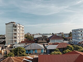
Tanga is a historic city and the capital of Tanga Region. The city is the most northernly port city of Tanzania to the west of the Indian Ocean on Tanga Bay. The city has a population of 393,429 in 2022. Tanga is governed by the Tanga City Council. The city is also home to the Port of Tanga. The name Tanga means "sail" in Swahili. The city is also the capital of Tanga District.

Tanga Region is one of Tanzania's 31 administrative regions. The region covers an area of 26,667 km2 (10,296 sq mi). The region is comparable in size to the combined land area of the nation state of Burundi. The regional capital is the municipality of Tanga city. Located in northeast Tanzania, the region is bordered by Kenya and Kilimanjaro Region to the north; Manyara Region to the west; and Morogoro and Pwani Regions to the south. It has a coastline to the east with the Indian Ocean. According to the 2022 national census, the region had a population of 2,615,597.

The Amboni Caves are a limestone cave complex in East Africa. They are located in Kiomoni ward of Tanga in Tanga Region of Tanzania off the Tanga-Mombasa road, 8 km north of Tanga City center. The reported length of the longest cave is 755m. The caves were formed about 150 million years ago during the Jurassic age. It covers an area of 234 km². According to researchers the area was under water some 20 million years ago. There are altogether ten caves but only one is used for guided tours.
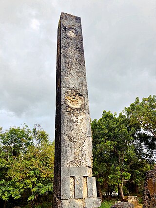
The Tongoni Ruins are a 15th century Swahili ruins of a mosque and forty tombs located in Tongoni ward in Tanga District inside Tanga Region of Tanzania. The largest and possibly most significant Swahili site in Tanzania is Tongoni, which is located 25 km north of the Pangani River. Overlooking Mtangata Bay, about forty standing tombs and a Friday mosque of the "northern" style occupy a third of a hectare. People from the area continue to worship there spiritually. They bury their departed family members to the south of the historic tombs. The area was a different place four to five centuries ago. Contrary to its almost unnoticed presence today, it was a prosperous and a respected Swahili trading centre during the 15th century. Most of the ruins are still not yet been uncovered. The site is a registered National Historic Site.

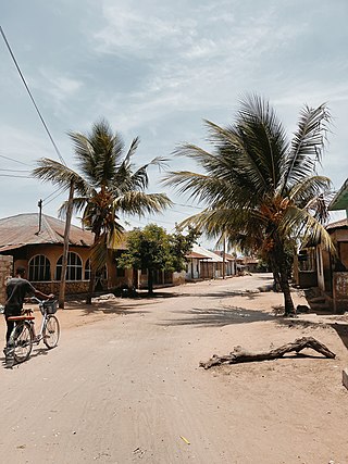
Pangani is a historic town and capital of Pangani District in the Tanga Region of Tanzania. The town lies 45 km (28 mi) south of the city of Tanga, at the mouth of the Pangani River in which the town is named after. Administrately the town Pangani is situated within two wards, Pangani Mashariki and Pangani Magharibi. The town is currently the largest settlement in Pangani District and is a major tourist attraction in Tanga region and is a home to Muhembo, a Tanzanian National Historic Site.

Maziwi island officially, The Maziwe Island Marine Reserve is a unvegetated, protected island surrounded by coral reefs located about 8 kilometres (5.0 mi) south east of the town of Pangani off the northern coast of Tanga Region in Tanzania. The island is administered under Mwera ward of Pangani District. However, it is currently under the Tanga Marine Reserves System. It became a nature reserve in 1975. At one time the island was larger than its present area and was well-vegetated but with the loss of its coconut trees and scrub cover, it has suffered erosion and is now sometimes completely immersed at the time of the highest tides. Green sea turtles no longer nest on the island, but it is visited by numerous sea birds. The sea contains many species of coral and over two hundred species of fish. The reserve has received little active conservation work but management is now supported by levying a small fee on tourists which is used to compensate local fishermen for loss of income.
The Tanga Coelacanth Marine Park (TCMP) is a Marine park in Tanzania, with the IUCN category II located within Tanga Region of Tanzania. The Tanga Coelacanth Marine Park (TACMP), which covers the entirety of Tanga City and all Coastal Areas from Tanga Bay and South of the Fishing Village of Kigombe, was Gazetted in 2009 by the Government of Tanzania (GoT) in recognition of the value of the Coelacanths and for their protection. Coelacanths have been spotted on Tanga Island, Mwambani Bay, Yambe Island, and Karange Island, all of which are part of the Park.

National Historic Sites of Tanzania is an official list of places in Tanzania that have been designated as National Historic Sites as per the Ministry of Natural Resources and Tourism of Tanzania under the Antiquities Division. The list is not complete and is currently being updated.

Central is an administrative ward in Tanga City Council of Tanga Region in Tanzania. Tanga Bay borders the ward on its northern side. Pemba Channel lies to the east, and Mzingani, Usagara, Ngamiani Kaskazini, and Majengo ward are to the south. The Chumbageni ward is to the west. The ward covers an area of 3.8 km2 (1.5 sq mi), and has an average elevation of 10 m (33 ft). The ward seat is Halmashauri ya Jiji and is home to the Port of Tanga. According to the 2012 census, the ward has a total population of 5,739.
Chongoleani(Kata ya Chongoleani , in Swahili) is an administrative ward in Tanga City Council of Tanga Region in Tanzania. The Mtimbwani and Kwale wards of Mkinga border the ward to the north. Tanga Bay of Pemba Channel is to the east. The Tanga Bay is to the south. Mabokweni ward is to the west. The ward covers an area of 37 km2 (14 sq mi). and has an average elevation of 10 m (33 ft). According to the 2012 census, the ward has a total population of 4,737.

Chumbageni(Kata ya Chumbageni , in Swahili) is an administrative ward in Tanga City Council of Tanga Region in Tanzania. Tanga Bay and Mzizima Ward, which are separated by the Mkulumuzi River and Tanga Bay, border the ward to the north. Central ward is to the east. Majengo, Mwanzange, and Nguvumali wards are to the south. Kiomoni ward is to the west. The ward covers an area of 2.5 km2 (0.97 sq mi), and has an average elevation of 23 m (75 ft). According to the 2012 census, the ward has a total population of 14,225.

Kiomoni is an administrative ward in Tanga City Council of Tanga Region in Tanzania. The Mzizima, Gombero, and Mnyenzani wards the latter two of Mkinga, surround the ward on its northern side. Chumbageni and Nguvumali wards are to the east. Maweni and Pongwe wards are located to the south. The Muheza District wards of Mlingoni and Pande Darajani are to the west. The ward covers an area of 83.5 km2 (32.2 sq mi), and has an average elevation of 52 m (171 ft). The ward is home to the Amboni Caves and also the largest limestone mine in the country. According to the 2012 census, the ward has a total population of 6,587.
Kirare is an administrative ward in Tanga City Council of Tanga Region in Tanzania. Marungu forms the ward's northern boundary. Tongoni is to the east. Kigombe ward is in the south. The Muheza District ward of Ngomeni is to the west. The ward covers an area of 55.6 km2 (21.5 sq mi), and has an average elevation of 39 m (128 ft). According to the 2012 census, the ward has a total population of 4,756.
Msambweni is an administrative ward in Tanga City Council of Tanga Region in Tanzania. Ngamiani Kusini forms the northern boundary of the ward. Makorora is the ward that is borered to the east. The Mabawa and Duga ward is to the south. The Mwanzange is to the west. The ward covers an area of 0.7 km2 (0.27 sq mi), and has an average elevation of 18 m (59 ft). According to the 2012 census, the ward has a total population of 9,610.

Mzizima is an administrative ward in Tanga City Council of Tanga Region in Tanzania. Mabokweni ward borders the ward on its northern side. To the east are Chumbageni and Tanga Bay. The ward of Kiomoni is to the south. The Gombero ward of Mkinga is to the west. The ward covers an area of 56.2 km2 (21.7 sq mi), and has an average elevation of 97 m (318 ft). The Sigi River traverses through the ward into Tanga Bay. The ward is also home to the Mzizima Hot Springs also known as Galanos Hot Springs. According to the 2012 census, the ward has a total population of 11,570.
Kwale Island is a protected, seasonally inhabited island in the Pemba Channel under the Tanga Marine Reserves (TMRS) with the IUCN category II located inside Kwale ward in Mkinga District of Tanga Region in Tanzania. The coral island, located approximately a kilometer offshore in Manza Bay, and the modern hamlet on the shoreline are both referred to as Kwale. 86.2% of Kwale Island, or 528.1 Ha, is covered with mangroves. Kwale Island and Ulenge Island are the only seasonally inhabited by islands in the marine reserve, thus the two have the most human impact. The Island has an average elevation of 7 m (23 ft).
Kirui Island officially, Kirui Island Marine Reserve is a protected, uninhabited island in the Pemba Channel under the Tanga Marine Reserves (TMRS) with the IUCN category II located within Mkinga District of Tanga Region in Tanzania. The Island is the largest in Tanga and one of the largest protected marine Islands in Tanzania Mangroves are thought to cover 680 ha (ha) of the island of Kirui, with the largest mangrove area being on the north and west sides, Kigomeni mangrove being on the east coast, and Kirui South Mangrove being on the south.
The Tanga Marine Reserves System (TMRS) is a group of marine reserves in the Tanga Region of Tanzania. All TMRs, though, serve as significant sea bird breeding areas. The Tanga Marine Reserves are: Kirui Island, Maziwe Island, Ulenge Island, Kwale Island and Mwewe Island.
Mwewe Island officially, Mwewe Island Marine Reserve is a protected, uninhabited island in the Pemba Channel under the Tanga Marine Reserves (TMRS) with the IUCN category II located within Mkinga District of Tanga Region in Tanzania. Acoording to oral Digo history, the island was used by some Kirui Island residents, Mwewe Island was eventually purchased by Sultan Bin Athmani of Moa.
Ulenge Island officially, Ulenge Island Marine Reserve is a protected, seasonally habited island in the Tanga Bay of Pemba Channel under the Tanga Marine Reserves (TMRS) with the IUCN category II located within Tanga City Council of Tanga Region in Tanzania. Kwale Island and Ulenge Island are the only islands in the marine reserve that are seasonally inhabited. Of Tanga's whole marine reserves system, Ulenge Island is the most degraded. Ulenge's reefs had the lowest fish numbers and the lowest coral cover and species diversity. This is mostly because Tanga Bay and Tanga City Council are nearby, which has a greater negative human impact. Ulenge Island is nicknamed by English speakers as Bird Island due to its importance as a seabird sanctuary.

