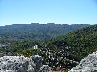
The Cumberland Mountains are a mountain range in the southeastern section of the Appalachian Mountains. They are located in western Virginia, southwestern West Virginia, eastern edges of Kentucky, and eastern middle Tennessee, including the Crab Orchard Mountains. Their highest peak, with an elevation of 4,223 feet (1,287 m) above mean sea level, is High Knob, which is located near Norton, Virginia.

Étretat is a commune in the Seine-Maritime department in the Normandy region of Northwestern France. It is a tourist and farming town situated about 32 km (20 mi) northeast of Le Havre, at the junction of the D 940, D 11 and D 139 roads. It is located on the coast of the Pays de Caux area. In 2017, it had a population of 1,291.

Chicoma Mountain is the highest point in the Jemez Mountains, a prominent mountain range in the U.S. State of New Mexico. The tree line in this area is exceptionally high, and the mountain is forested almost all the way to its summit which is conspicuous from the towns of Los Alamos, Santa Fe, and Española and other areas in the valley of the Rio Grande in northern New Mexico. Like the rest of the Jemez, it is of volcanic origin; it lies on the northeast rim of the Valles Caldera, one of the best examples of a caldera in the United States.

Helliwell Provincial Park is a provincial park in British Columbia, Canada located on a headland at the northeast end of Hornby Island.

Bowleaze Cove is a small sand and shingle beach, near the village of Preston, just to the northeast of Weymouth, Dorset, England. The cove is on the Jurassic Coast and is known for its geology. Just to the west is Furzy Cliff.

Azzone is a comune (municipality) in the Province of Bergamo in the Italian region of Lombardy, located about 90 kilometres (56 mi) northeast of Milan and about 45 kilometres (28 mi) northeast of Bergamo. As of 31 December 2004, it had a population of 458 and an area of 16.8 square kilometres (6.5 sq mi).

Cumberland Basin is an inlet and northeasternmost part of the Bay of Fundy, located on the border between the Canadian provinces of Nova Scotia and New Brunswick.
Clifton Cushman was an American athlete who competed mainly in the 400 metre hurdles.

The West Hartford Reservoir recreation area is located on the western edge of West Hartford, Connecticut and 2.5 miles (4.0 km) northeast of Farmington, Connecticut. There are six large reservoirs along the eastern part of the park and a paved cycling trail that winds through the southern portion. The blue-blazed Metacomet Trail follows the highest ridge of the area and the network of trails throughout the area has led this to be a local mecca for mountain bikers, hikers, and trail-runners. The western edge is marked by Deer Cliff, a high rocky ledge that runs for about 1.5 miles (2.4 km) north-south. The Deer Cliff ledges have a long tradition of climbing routes for local mountaineers, but at this time the private access to the cliff base has been closed to the public. The Revolutionary War Campsite historical site is located near reservoir #6.

High Cliff State Park is a 1,187-acre (480 ha) Wisconsin state park near Sherwood, Wisconsin. It is the only state-owned recreation area located on Lake Winnebago. The park got its name from cliffs of the Niagara Escarpment, a land formation east of the shore of Lake Winnebago that stretches north through northeast Wisconsin, Upper Michigan, and Ontario to Niagara Falls and New York State.

Koga is an impact crater on Mars, approximately 19 kilometers in diameter. It is located at 29.3°S, 103.8°W, north of the crater Virrat and northeast of the crater Dinorwic. To the north is the crater Nhill. It is named after a town in Tanzania, and its name was approved by the International Astronomical Union in 1991. According to a surface age map of Mars based on US Geological Survey data, the area around Koga is from the Noachian epoch, which places the area's age at 3.8 to 3.5 billion years ago. Sharp blocks and cliffs poke through a mantle of fine material located at the bottom of the crater. At the deepest part of the crater, it is about 5,200 meters in elevation above zero altitude, and its rim averages about 6,400 meters above zero altitude. It is therefore approximately 1.2 kilometers deep.

Cliff Mountain is a mountain located in Essex County, New York. The mountain is part of the Marcy Group of the Great Range of the Adirondack Mountains. Cliff is flanked to the southeast by Mount Redfield.

Mount Redfield is a mountain located in Essex County, New York. The mountain is part of the Marcy Group of the Great Range of the Adirondack Mountains. Mount Redfield is flanked to the northwest by Cliff Mountain, and to the northeast by Mount Skylight.
Fraser Island is an uninhabited island in the Qikiqtaaluk Region of Nunavut, Canada. It is located at the mouth of Hudson Bay off Nottingham Island's northwestern tip. The closest community is the Inuit hamlet of Cape Dorset, 120 km (75 mi) to the northeast on Baffin Island.

The Red Mountain Wilderness (Utah) is a 18,729-acre (75.8 km2) wilderness area in the US state of Utah. It was designated March 30, 2009, as part of the Omnibus Public Land Management Act of 2009. Located six miles northeast of St. George, it is bordered by Snow Canyon State Park to the east and the Shivwitz Indian Reservation to the southwest. Approximately one-half of the wilderness is located within the recently designated Red Cliffs National Conservation Area. Prehistoric use by the Southern Paiute Indians has been documented at seven sites in the area, and the BLM estimates archeological site densities between 4 and 40 per square mile.
Appaalissiorfiup Ikerasaa is a strait in the Qaasuitsup municipality in northwestern Greenland.

Red Cliff Air Station was a General Surveillance Radar station. The remains of which are located 5.8 miles (9.3 km) north-northeast of St. John's, Newfoundland and Labrador, Canada. It was closed in 1961.

The Moccasin Mountains is an 11-mile-long (18 km) mountain range located at the Arizona–Utah border in Mohave County, Arizona, and a small north section in Kane County, Utah.

Poke-O-Moonshine Mountain, spelled Pokamoonshine on U.S. Geological Survey maps, and sometimes known as just Poke-O, is a minor peak of the Adirondack Mountains. The name is believed to be a corruption of the Algonquin words pohqui, meaning 'broken', and moosie, meaning 'smooth'. It is located in the town of Chesterfield, New York, United States, on New York state Forest Preserve land, part of the Taylor Pond Wild Forest complex within the Adirondack Park. Due to its location next to the pass through which most travelers from the north enter the range, it has been called the "gateway to the Adirondacks".

The Peacock Mountains are a small, 26-mi (42 km) long mountain range in northwest Arizona, USA. The range is a narrow sub-range, and an extension north, at the northeast of the Hualapai Mountains massif, which lies to the southwest. The range is defined by the Hualapai Valley to the northwest, and north and south-flowing washes on its east border, associated with faults and cliffs; the Cottonwood Cliffs are due east, and are connected to the Aquarius Cliffs southward at the west perimeter of the Aquarius Mountains; the cliffs are a result of the Aquarius Fault, which is an extension southward from the Grand Wash Cliffs and Grand Wash Fault which crosses the Colorado River at Lake Mead, and the west perimeter of the Grand Canyon/Colorado Plateau.


