
Mavelikkara is a taluk and municipality in the Alappuzha district of the Indian state of Kerala. Located in the southern part of the district on the banks of the Achankovil River. The name Mavelikara is believed to be turned out from the words Maveli or Mahabali, the mythical king of Kerala, and Kara means land. This land is believed to be the place 'Mattom Mahadeva temple'where king Mahabali knelt before Vamana, offering his head for Vamana to keep his feet. The town boasts about a rich historical and cultural background. The Chettikulangara Devi Temple, known for the Kumbha Bharani festival is located near the municipality. The place is home to one of the 108 Shiva temples of Kerala created by Lord Parashurama, the Kandiyoor Mahadeva Temple. It was also a major centre of trade and commerce in ancient Kerala and the erstwhile capital of the rulers of Onattukara. As a result of the close association with the Travancore Royal Family, Mavelikkara gained modern facilities well ahead of other places in the state. It is one of the oldest municipalities of the state. Even before India attained independence, Mavelikara had a super express transport service to Trivandrum.

Nemom is an area of the city of Thiruvananthapuram (Trivandrum). It is located 12 km (7 mi) to the south of the Thiruvananthapuram city center. Nemom falls within the municipal corporation of Thiruvananthapuram, though partly exclusive. It is connected with Thiruvananthapuram, Neyyattinkara, Vizhinjam, Poovar, Kattakkada, Nagarcoil, and Kanyakumari through the main arterial highway NH 66.
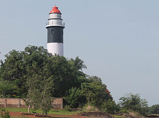
Koyilandy, IPA: [kojilɐːɳɖi], is a municipality in the taluk of the same name in Kozhikode district, Kerala on the Malabar Coast. The town is located between Kozhikode (Calicut) and Vadakara (Badagara) on National Highway 66.. Koyilandy is the 2nd most cleanest town of South India. Koyilandy harbour is the largest fishing harbour in Asia. The northern part of Pulimuttu is 1600 m long and the southern part is 915 m long. The picturesque Kappad beach lies near Koyilandy. India's first mangrove museum is situated in Koyilandy. Koyilandy is well connected to major towns like Kozhikode, Vatakara, Thamarassery, Balussery & Perambra.
Meppayur is a town in Kozhikode district of Kerala state, South India.

Bharanikkavu is a Panchayat in Alappuzha district in the Indian state of Kerala. The Village by the same name is a part of it. The name is derived from the historic Bharanikkavu Devi temple situated here.

Kuthiathode is a gram panchayat in Alappuzha district in the Indian state of Kerala.
Mannancherry is a village in Alappuzha district in Kerala, India. It is situated about 10 km north of Alappuzha town. Vembanad Lake forms the eastern boundary of the village. In governance, Mannancherry is a Panchayat. In parliamentary representation, it is part of the Alappuzha Assembly constituency, as well as the Alappuzha LokSabha constituency. The primary occupation of the village's inhabitants has been coir-making for the past several decades.
Puthuppally is a village in Alappuzha district in the Indian state of Kerala.It is just 3 km away from the Kayamkulam town. Vadakke Anjilimoodu is the main junction.
Eramalloor is a village in Alappuzha district in the Indian state of Kerala.
Marady is a village in Ernakulam district in the Indian state of Kerala.
Chirakkara is a village in Kollam district in the state of Kerala, India. Chirakkara is 16 km away from the City of Kollam and 8 km away from Paravur Town, which is famous for festivals, estuary, backwaters and beaches.
Chithara is a village in Kollam district in the state of Kerala, India.
Kizhakkekallada, also known as East Kallada, is a large village in the Kollam district in the state of Kerala, India. It is located about 20 kilometres (12 mi) northeast of Kollam.
Mulavana is a village in Kollam district in the state of Kerala, India. The place is filled with almost all types of shops,which includes stationary,fancy,textile etc. The Mulavana fish market is regarded as the best market while comparing with the surrounding places.

Pavithreswaram is a village in Kottarakkara taluk of Kollam district in the state of Kerala, India.
Perumpetty is a village in Pathanamthitta district in the state of Kerala, India.
Karakulam is a panchayat in Nedumangad Taluk in Tiruvananthapuram District in the state of Kerala, India. It is the most populated panchayat in the district according to 2011 census.
Parasuvaikkal is a village in Thiruvananthapuram district in the state of Kerala, India.
Vattappara is a village in Thiruvananthapuram district in the state of Kerala, India. , well known for its geographical peculiarities with quarries that are generally used for extracting building materials (rock).This town is by the side of MC Road connecting Trivandrum and Kottayam and 14 km away from Trivandrum City. The nearest township is Nedumangad.There is no recorded history on the origin of this place. The major occupation in Vattappara is farming(Rubber, Coconut).
Mupliyam is a small village near Pudukkad town in Thrissur district of Kerala state, south India. It is located 9 km away from NH 544 from Pudukad which is 13 km from Thrissur town. Mupliyam comes under Chalakudy Taluk and Varandarappilly Panchayath. The river which passes through Mupliyam becomes Kurumali river. Muniyattukunnu of Mupliyam is famous for its dolmens, which were declared as protected monument as per Government proceeding. Only one dolmen stands intact at Muniyattukunnu. The rest have been destroyed by quarrying in the area. India.

