Related Research Articles

The national parks of New Zealand are protected natural areas administered by the Department of Conservation (DOC). The first national parks established in the country were all focused on mountain scenery. Since the 1980s the focus has been on developing a more diverse representation of New Zealand landscapes. The parks are all culturally significant and many also contain historic features. Tongariro National Park is one of the World Heritage Sites that are of both cultural and natural significance, while four of the South Island national parks form Te Wahipounamu, another World Heritage Site. There are currently 13 national parks; a 14th, Te Urewera National Park, was disestablished in 2014.
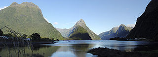
Milford Sound is a fiord in the south west of New Zealand's South Island within Fiordland National Park, Piopiotahi Marine Reserve, and the Te Wahipounamu World Heritage site. It has been judged the world's top travel destination in an international survey and is acclaimed as New Zealand's most famous tourist destination. Rudyard Kipling called it the eighth Wonder of the World. The fiord is most commonly accessed via road by tour coach, with the road terminating at a small village also called Milford Sound.
The Department of Conservation is the public service department of New Zealand charged with the conservation of New Zealand's natural and historical heritage.
Te Uru Rākau – New Zealand Forest Service is the agency within the Ministry for Primary Industries that is responsible for the New Zealand forestry sector. It is headquartered in Rotorua.

Fiordland National Park is a national park in the south-west corner of South Island of New Zealand. It is the largest of the 13 national parks in New Zealand, with an area covering 12,607 km2 (4,868 sq mi), and a major part of the Te Wāhipounamu a UNESCO World Heritage Site established in 1990. The park is administered by the Department of Conservation. The southern ranges of the Southern Alps cover most of Fiordland National Park, combined with the deep glacier-carved valleys.
Forest & Bird, also known by its formal name as the Royal Forest and Bird Protection Society of New Zealand, is an environmental organisation specialising in the protection and conservation of New Zealand's indigenous flora and fauna and unique wild places and natural ecosystems. Forest & Bird consists of 47 branches located in urban and rural centres throughout New Zealand. Branches are actively engaged in conservation projects and advocacy on a community, regional and national basis. Forest & Bird has offices and staff located in Auckland, Christchurch, Wellington, Nelson and Dunedin. Forest & Bird publishes a quarterly magazine Forest & Bird, one of New Zealand's definitive natural history and conservation publications.

Arthur's Pass National Park is located in the South Island of New Zealand and covers 1,185 km2 of mostly mountainous terrain. Adjacent to it lies Craigieburn Forest Park. The park is administered by the Department of Conservation.

Paparoa National Park is on the west coast of the South Island of New Zealand. The park was established in 1987 and encompasses 430 km2 (170 sq mi). The park ranges from or near the coastline to the peaks of the Paparoa Range. A separate section of the park lies to the north and is centred at Ananui Creek. The park protects a limestone karst area. The park contains several caves, of which Metro Cave / Te Ananui Cave is a commercial tourist attraction. The majority of the park is forested with a wide variety of vegetation. The park was the site of the 1995 Cave Creek disaster where fourteen people died as a result of the collapse of a scenic viewing platform.

New Zealand has 44 marine reserves that are spread around the North, the South Island, and neighbouring islands, and on outlying island groups. They are governed by the Marine Reserves Act 1971 and administered by the Department of Conservation with assistance from the Ministry for Primary Industries, New Zealand Customs Service and the New Zealand Defence Forces.

Protected areas of New Zealand are areas that are in some way protected to preserve their environmental, scientific, scenic, historical, cultural or recreational value. There are about 10,000 protected areas, covering about a third of the country. The method and aims of protection vary according to the importance of the resource and whether it is publicly or privately owned.

Te Urewera is an area of mostly forested, sparsely populated rugged hill country in the North Island of New Zealand, located inland between the Bay of Plenty and Hawke Bay. Te Urewera is the rohe of Tūhoe, a Māori iwi (tribe) known for its stance on Māori sovereignty.
The Ministry for the Environment is the public service department of New Zealand charged with advising the New Zealand Government on policies and issues affecting the environment, in addition to the relevant environmental laws and standards. The Environment Act 1986 is the statute that establishes the Ministry.
Transport in Milford Sound in New Zealand is characterised by the remoteness of the area in which it is located. As a popular tourism destination in the South Island, Milford Sound and the village of the same name receive very large numbers of visitors. These tend to arrive and depart within just a few hours each day, as there is little accommodation at the village, leading to strong demand peaks for tourism services during the noon and early afternoon period. The journey from Te Anau is rated as one of the most photographic drives of the world.
1080, the brand name given to the synthetic form of sodium fluoroacetate, is used in New Zealand in efforts to control populations of possums, rats, stoat and rabbits, which are invasive species in the New Zealand environment. Although the Parliamentary Commissioner for the Environment deemed the use of 1080 in New Zealand "effective and safe" in a 2011 re-evaluation and the substance is widely considered to be the most effective tool currently available for controlling possums over large areas, it remains a contentious issue, with the majority of the debate occurring between conservationists and livestock farmers on one side and hunters and animal-rights activists on the other.

The environment of New Zealand is characterised by an endemic flora and fauna which has evolved in near isolation from the rest of the world. The main islands of New Zealand span two biomes, temperate and subtropical, complicated by large mountainous areas above the tree line. There are also numerous smaller islands which extend into the subantarctic. The prevailing weather systems bring significantly more rain to the west of the country. New Zealand's territorial waters cover a much larger area than its landmass and extend over the continental shelf and abyssal plateau in the South Pacific Ocean, Tasman Sea and Southern ocean.
The Mokihinui Hydro was a proposed hydroelectric dam and power station planned for conservation land on the Mōkihinui River on the West Coast of New Zealand. The project by Meridian Energy was expected to cost $300 million.

Deforestation in New Zealand has been a contentious environmental issue in the past, but native forests now have legal protection, and are not allowed to be tampered with by humans.

Eugenie Meryl Sage is a New Zealand environmentalist and former politician. She was a Green Party Member of Parliament in the New Zealand House of Representatives from 2011 to 2023.

The Haast-Hollyford road or Haast-Hollyford Highway is a long-standing proposal to link Haast via the Hollyford Valley to Milford Sound and Te Anau in the South Island of New Zealand. Proposals for this road have been mooted since the 1880s.

Aotea Conservation Park is a 12,300 hectare protected area on Great Barrier Island in New Zealand's Hauraki Gulf. It was established in 2015, and comprises 43 percent of the island.
References
- ↑ Introduced Animals Archived 24 November 2005 at the Wayback Machine , Christchurch Library.
- ↑ Rabbits Archived 17 August 2005 at the Wayback Machine Christchurch Library.
- 1 2 3 4 5 6 "MfE State of Environment Report, 1997". mfe.govt.nz. Archived from the original on 19 October 2013. Retrieved 19 April 2018.
- ↑ "Exportation of Stoats and Weasels". The Cornishman. No. 302. 1 May 1884. p. 6.
- 1 2 3 4 Pink, Brian (16 April 2003). "New Zealand Population To Reach 4 Million (April 2003)". Statistics New Zealand. Archived from the original on 4 March 2016. Retrieved 18 March 2012.
- ↑ "Te-Urewera-National-Park-Management-Plan". doc.govt.nz. Archived from the original on 6 September 2004. Retrieved 19 April 2018.
- ↑ Rudd facts Archived 16 October 2008 at the Wayback Machine DOC website, retrieved 16 September 2007.
- ↑ History of EDS Archived 4 June 2004 at the Wayback Machine EDS web site.
- 1 2 About ECO Archived 15 October 2004 at the Wayback Machine ECO website.
- ↑ "Greenpeace NZ website FAQ". greenpeace.org.nz. Archived from the original on 13 October 2004. Retrieved 19 April 2018.
- ↑ "New Zealand Legislation". Archived from the original on 7 February 2012. Retrieved 4 September 2018.
- 1 2 "New Zealand Legislation". www.legislation.govt.nz. Retrieved 19 April 2018.
- ↑ "NZ Govt. Legislation". legislation.govt.nz. Archived from the original on 30 April 2005. Retrieved 19 April 2018.
- ↑ "Native Forest Restoration Trust". Archived from the original on 2 October 2008. Retrieved 2 October 2004.
- 1 2 Wheen, N. (2002) A history of New Zealand environmental law. pp 261-274, In Environmental histories of New Zealand, edited by Pawson, E. and Brooking,T. Oxford University Press, Melbourne, page 268.
- ↑ "New Zealand Legislation". www.legislation.govt.nz. Retrieved 19 April 2018.
- 1 2 3 "UNESCO". unesco.org. Retrieved 19 April 2018.
- ↑ "Greens history". greens.org.nz. Archived from the original on 10 October 2008. Retrieved 19 April 2018.
- ↑ "Green Ribbon Award". mfe.govt.nz. Archived from the original on 27 March 2014. Retrieved 19 April 2018.
- ↑ The Press. 24 August 2004
- ↑ NZ Justice Department
- ↑ "Native Forest Action New Zealand - Defending New Zealand's native forests from logging by SOE Timberlands West Coast". www.converge.org.nz. Retrieved 19 April 2018.
- ↑ "Wild Greens". greens.org.nz. Archived from the original on 26 September 2007. Retrieved 19 April 2018.
- ↑ "Zero Waste New Zealand Ltd". www.zerowaste.org.nz. Retrieved 19 April 2018.
- ↑ New Zealand Department of Conservation. "Nature" (PDF). www.doc.govt.nz. Retrieved 19 April 2018.
- ↑ Varroa FAQ at Biosecurity New Zealand
- ↑ "Restoring bird life to the Kapiti Coast". Archived from the original on 13 October 2004. Retrieved 2 October 2004.
- ↑ "Waste Strategy". mfe.govt.nz. Archived from the original on 25 July 2013. Retrieved 19 April 2018.
- ↑ "Ecological footprint" (PDF). panda.org. Retrieved 19 April 2018.
- ↑ "Campbell Island conservation sanctuary rat free". New Zealand Government. 27 May 2003. Retrieved 12 October 2021.
- ↑ "Clean Streams Accord" (PDF). ew.govt.nz. Archived from the original (PDF) on 13 March 2006. Retrieved 19 April 2018.
- ↑ "Minister approves moves on Rotorua lakes". New Zealand Government. 11 September 2003. Retrieved 12 October 2021.
- ↑ "NZ Herald: New Zealand's Latest News, Business, Sport, Weather, Entertainment, Politics". The New Zealand Herald. Retrieved 19 April 2018.[ permanent dead link ]
- ↑ Didymo
- ↑ "Home". Environment Canterbury. Retrieved 19 April 2018.[ permanent dead link ]
- ↑ "Home". Environment Canterbury. Archived from the original on 27 September 2004. Retrieved 19 April 2018.
- ↑ "Home". Environment Canterbury. Archived from the original on 7 September 2004. Retrieved 19 April 2018.
- ↑ "Million dollar conservation project restores Raoul". New Zealand Government. 24 September 2004.
- ↑ "Right Decision on Mt Burnett's Endangered Species - Scoop News". www.scoop.co.nz. Retrieved 19 April 2018.
- ↑ "Project Aqua". meridianenergy.co.nz. Archived from the original on 27 September 2007. Retrieved 19 April 2018.
- ↑ "Hunting in New Zealand". Archived from the original on 21 June 2009. Retrieved 28 April 2009.
- ↑ "Latest News". KASM - Kiwis against Seabed Mining. Archived from the original on 2 October 2008. Retrieved 19 April 2018.
- ↑ "West Coast Iron Sand Mining 2005". www.option4.co.nz. Retrieved 19 April 2018.
- ↑ O'Sullivan, Fran (14 March 2005). "Chinese explorer eyes NZ gas fields". The New Zealand Herald . Retrieved 22 November 2011.
- ↑ "New Zealand Legislation". Archived from the original on 10 February 2012. Retrieved 4 September 2018.
- ↑ [ permanent dead link ]
- ↑ "Business and environment-friendly tax changes - Ministry for the Environment". www.mfe.govt.nz. Retrieved 19 April 2018.
- ↑ "DOC Media Release". Archived from the original on 16 February 2006. Retrieved 29 April 2005.
- ↑ "Solid Energy New Zealand Ltd : Premium Export Coal : Export Coals of New Zealand : New Zealand Coal Mining". Archived from the original on 5 November 2006. Retrieved 27 May 2005.
- ↑ "Welcome to Forest and Bird". Archived from the original on 27 August 2006. Retrieved 27 May 2005.
- ↑ "Cypress mine shows shortsighted 'dig-it-up' attitude - Green Party". Archived from the original on 19 May 2006. Retrieved 27 May 2005.
- ↑ "Molesworth Station to become high country park". New Zealand Government. 19 December 2003. Retrieved 12 October 2021.
- ↑ Industries, Ministry for Primary. "Home". MPI. Retrieved 19 April 2018.
- ↑ "Media Release — Milford Dart". Archived from the original on 11 January 2007. Retrieved 30 January 2006.
- ↑ "Environmental Performance Index: Redirect". yale.edu. Archived from the original on 17 June 2007. Retrieved 19 April 2018.
- ↑ "Pipe bomb explodes outside conservationist's home". The New Zealand Herald . 10 April 2006. Retrieved 22 November 2011.
- ↑ "New threatened species list: Media release". doc.govt.nz. Archived from the original on 14 October 2008. Retrieved 19 April 2018.
- ↑ Wikinews:OECD releases report on New Zealand's environmental performance
- ↑ "Bottom trawling and dredging banned around NZ". New Zealand Herald. 4 April 2007. Retrieved 12 October 2021.
- ↑ "Beehive - Abandoned Tui mine to be cleaned up". beehive.govt.nz. Retrieved 19 April 2018.
- ↑ "Beehive - NZ and Australia close orange roughy fishery". beehive.govt.nz. Archived from the original on 16 October 2008. Retrieved 19 April 2018.
- ↑ "Beehive - Research on New Zealanders' environmental actions". beehive.govt.nz. Archived from the original on 17 October 2008. Retrieved 19 April 2018.
- ↑ "Table 2: The Travel & Tourism Competitiveness Index: Regulatory framework" (PDF). World Economic Forum. 2008.
- ↑ New Zealand's Greenhouse Gas Inventory 1990-2006: An Overview. Ministry for the Environment (New Zealand). April 2008. ISBN 978-0-478-30222-6.
- ↑ "Rena grounding NZ's worst maritime disaster". Radio New Zealand. 11 October 2011. Retrieved 11 October 2011.
- ↑ Woodford, Darragh J.; McIntosh, Angus R. "Effects of introduced trout predation on non-diadromous galaxiid fish populations across invaded riverscapes" (PDF). www.doc.govt.nz. New Zealand Department of Conservation.