Tizaung

Last updated
Tizaung
Village
Sagaing, Burma map.png
Red pog.svg
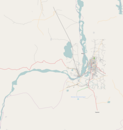
Tizaung
Location in the Sagaing area and in relation to the Irrawaddy River.
Coordinates: 21°58′N95°36′E / 21.967°N 95.600°E / 21.967; 95.600 Coordinates: 21°58′N95°36′E / 21.967°N 95.600°E / 21.967; 95.600
Country Flag of Myanmar.svg  Burma
Region Sagaing Region
District Sagaing District
Township Myinmu Township
Time zone UTC+6.30 (MST)

Tizaung is a village in the southeast of the Sagaing Division in Burma. It is located about 2 miles northeast of the township centre of Myinmu by road. The settlement of Paukka also lies by road to the east.

Tizaung contains a notable pagoda. [1]

Related Research Articles

Myanmar Country in Southeast Asia

Myanmar, officially the Republic of the Union of Myanmar, also called Burma, is a country in Southeast Asia. It is the largest country in Mainland Southeast Asia, and has a population of about 54 million as of 2017. Myanmar is bordered by Bangladesh and India to its northwest, China to its northeast, Laos and Thailand to its east and southeast, and the Andaman Sea and the Bay of Bengal to its south and southwest. The country's capital city is Naypyidaw, and its largest city is Yangon (Rangoon).

Yangon Largest City in Yangon Region, Myanmar

Yangon, also known as Rangoon, is the capital of the Yangon Region and the largest city of Myanmar. Yangon served as the capital of Myanmar until 2006, when the military government relocated the administrative functions to the purpose-built capital city of Naypyidaw in north central Myanmar. With over 7 million people, Yangon is Myanmar's most populous city and its most important commercial centre.

Mandalay Second-largest city in Myanmar

Mandalay is the second-largest city in Myanmar, after Yangon. Located on the east bank of the Irrawaddy River, 716 km (445 mi) north of Yangon, the city has a population of 1,225,553.

Magway Region Region of Myanmar

Magway Region is an administrative division in central Myanmar. It is the second largest of Myanmar's seven divisions, with an area of 44,820 km2. Pa Del Dam (ပဒဲဆည်) is one of the dams in Aunglan Township, Magway Division. The capital and second largest city of the Magway Division is Magway. The largest city is Pakokku. The major cities of Magway Division are Magway, Pakokku, Aunglan, Yenangyaung, Taungdwingyi, Chauk, Minbu, Thayet and Gangaw.

Chin State State of Myanmar

Chin State is a state in western Myanmar. The 36,019-square-kilometre (13,907 sq mi) Chin State is bordered by Sagaing Division and Magway Division to the east, Rakhine State to the south, Bangladesh to the south-west, and the Indian states of Mizoram to the west and Manipur to the north. The population of Chin state is about 478,801 in 2014 census. The capital of the state is Hakha. The state is a mountainous region with few transportation links. Chin State is sparsely populated and remains one of the least developed areas of the country. Chin State has the highest poverty rate of 73% as per the released figures from the first official survey. The official radio broadcasting dialect of Chin is Falam. There are 53 different subtribes and languages in Chin State. There are nine townships in Chin State: Hakha, Thantlang, Falam, Tedim, Tonzang, Matupi, Mindat, Kanpetlet and Paletwa townships. In 1896, Mindat and Kanpetlet were placed under Pakokku Hill Tracts District of British Burma later emerged into Chin hills. Only Paletwa township became a part of Arakan Hill Tracts District of British Burma.

Kayah State State of Myanmar

Kayah State is a state of Myanmar. Situated in eastern Myanmar, it is bounded on the north by Shan State, on the east by Thailand's Mae Hong Son Province, and on the south and west by Kayin State. It lies approximately between 18° 30′ and 19° 55′ north latitude and between 96° 50′ and 97° 50′ east longitude. The area is 11,670 km2 (4,510 sq mi). Its capital is Loikaw. The estimated population in 1998 was approximately 207,357, according to UNICEF. It is inhabited primarily by the Karenni ethnic group, also known as Red Karen or Kayah, a Sino-Tibetan people.

Naypyidaw Capital of Myanmar

Naypyidaw, officially spelled Nay Pyi Taw, is the capital and third-largest city of Myanmar. The city is located at the centre of the Naypyidaw Union Territory. It is unusual among Myanmar's cities, as it is an entirely planned city outside of any state or region. The city, then known only as Pyinmana District, officially replaced Yangon as the administrative capital of Myanmar on 6 November 2005; its official name was revealed to the public on Armed Forces Day, 27 March 2006.

Pakokku City in Magway Region, Myanmar

Pakokku is the largest city in the Magway Region of Myanmar. It is situated about 30 km north-east of Bagan on the Irrawaddy River. It is the administration seat of Pakokku Township, Pakokku District and Gangaw District. Pakokku Bridge is part of the India–Myanmar–Thailand Trilateral Highway and is the longest bridge in Myanmar. It is home of the Pakokku Airport.

Central Bank of Myanmar Central Bank of Myanmar

The Central Bank of Myanmar is the central bank of Myanmar.

The traditional Burmese units of measurement were a system of measurement used in Myanmar.

Myinmu is a river town in the south-east of the Sagaing Division in Burma. The town has a rich history linked to World War II during the Burma Campaign against the Japanese, in 1944. It was also under the control of the Portuguese Missionaries in the 19th century. One of the first agricultural cooperatives was established here in 1905.

Hopang Township is a township of the Wa Self-Administered Division in the Shan State of Burma. The principal town is Hopang. It is one of the 6 townships of Wa Self-Administered Division. It became part of Hopang District instead of Kunlong District in 2011.

Constitution of Myanmar Supreme legal document of the Republic of the Union of Myanmar

The Constitution of the Republic of the Union of Myanmar is the supreme law of Myanmar. Myanmar's first constitution adopted by constituent assembly was enacted for the Union of Burma in 1947. After the 1962 Burmese coup d'état, a second constitution was enacted in 1974. The country has been ruled by military juntas for most of its history.

Muse, Myanmar Town in Shan State, Myanmar

Muse is the capital town of Mu Se Township in northern Shan State, Myanmar. It is situated on the Shweli River, and is connected by a bridge and road to Ruili in Yunnan Province, China.

Namhkam, Shan State Town in Shan State, Myanmar

Namhkam, also spelled Nam Kham is the principal town of Namhkam Township in northern Shan State, Myanmar, situated on the southern bank of the Shweli River near the border with Yunnan Province, China.

Myinmu Township Township in Sagaing Region, Burma

Myinmu Township is a township in the southeast of the Sagaing Division in Burma (Myanmar), west of Mandalay. The principal town is Myinmu which lies on the northern bank of the Irrawaddy River. History of Myinmu is closely linked to the World War II against the Japanese Army when British General Sir Douglas Gracey occupied the town after crossing the Irrawaddy River.

Paukka, Myinmu Village in Sagaing Region, Burma

Paukka is a small village in the southeast of the Sagaing Division in Burma. It is located east by road from Tizaung and the township seat of Sagaing. The village of Legyi lies to the east.

Pyidaungsu Hluttaw National legislature of Myanmar

The Pyidaungsu Hluttaw is the de jure national-level bicameral legislature of Myanmar established by the 2008 National Constitution. The Pyidaungsu Hluttaw is made up of two houses, the Amyotha Hluttaw, a 224-seat upper house as well as the Pyithu Hluttaw, a 440-seat lower house.

2015 Myanmar general election Elections held in Myanmar on 8 November 2015

General elections were held in Myanmar on 8 November 2015, with the National League for Democracy winning a supermajority of seats in the combined national parliament. Voting occurred in all constituencies, excluding seats appointed by the military, to select Members of Assembly to seats in both the upper house and the lower house of the Assembly of the Union, and State and Region Hluttaws. Ethnic Affairs Ministers were also elected by their designated electorates on the same day, although only select ethnic minorities in particular states and regions were entitled to vote for them.

2008 Constitution of Myanmar Current supreme legal document of the Republic of the Union of Myanmar

The Constitution of the Republic of the Union of Myanmar (2008) is the third Constitution of Myanmar after 1947 and 1974 constitutions which were aborted by military coups. It is part of the seven steps road map announced by then Prime Minister of State Peace and Development Council government General Khin Nyunt on 30 August 2003. One of the seven steps include recalling of National Convention for the drafting of new constitution which was adjourned on 31 March 1996 by State Law and Order Restoration Council government.

References

  1. Historical sites in Burma. Ministry of Union Culture, Govt. of the Union of Burma. 1978. p. 40.