Related Research Articles

The Bay of Fundy is a bay between the Canadian provinces of New Brunswick and Nova Scotia, with a small portion touching the US state of Maine. It has an extremely high tidal range. The name is likely a corruption of the French word Fendu, meaning "split".

Protected areas of South Australia consists of protected areas located within South Australia and its immediate onshore waters and which are managed by South Australian Government agencies. As of March 2018, South Australia contains 359 separate protected areas declared under the National Parks and Wildlife Act 1972, the Crown Land Management Act 2009 and the Wilderness Protection Act 1992 which have a total land area of 211,387.48 km2 (81,617.16 sq mi) or 21.5% of the state's area.
Kejimkujik National Park is a National Park of Canada, covering 404 km2 (156 sq mi) in the southwest of Nova Scotia peninsula. It consists of two separate land areas: an inland part, which is coincident with the Kejimkujik National Historic Site of Canada, and the Kejimujik National Park Seaside on the Atlantic coast.

The Mersey River, formerly known as Rivière Rossignol by the Acadians, is a river in Nova Scotia, Canada. It is named after the River Mersey in Liverpool, England. The river proper flows from the eastern end of Eleven Mile Lake in Annapolis County southward to Kejimkujik Lake in Kejimkujik National Park, then through Lake Rossignol to empty into the Atlantic Ocean at the town of Liverpool, Nova Scotia. The true source of the river however is as far northwest as Sandy Bottom Lake or Tuskopeake Brook on the northern tributary.

La Vérendrye wildlife reserve is one of the largest reserves in the province of Quebec, Canada, covering 12,589 square kilometres of contiguous land and lake area. It is named after Pierre Gaultier de Varennes, sieur de La Vérendrye, a French-Canadian explorer. Located 180 kilometres (110 mi) north of Ottawa, it is traversed from south to north by Route 117.

Bowron Lake Provincial Park is a provincial park located in northern British Columbia, Canada, about 117 km (73 mi) east of the city of Quesnel. Other nearby towns include Wells and the historic destination of Barkerville. The park is known for its rugged glaciated mountains, cold deep lakes, waterfalls, and abundant wildlife.
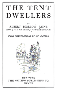
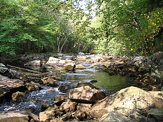
The Tent Dwellers is a book by Albert Bigelow Paine, chronicling his travels through inland Nova Scotia on a trout fishing trip with Dr. Edward "Eddie" Breck, and with guides Charles "the Strong" and Del "the Stout", one June in the early 1900s. Originally published in 1908, The story starts at what is now known as the Legendary Milford House; Renowned author Albert Bigelow Paine,, chronicled his first impression of the Milford House Lodge in his famous book, in the following way … "Then at last came a church, a scattering string of houses, a neat white hotel and the edge of the wilderness had been reached." Those travelling today from Annapolis Royal will witness little change in the scenery or the impact from this turn of the century description. The book takes place in what is now Kejimkujik National Park and the adjacent Tobeatic Game Reserve. The Reserve later became the Tobeatic Wildlife Management Area, and in 1998 was included within the newly created Tobeatic Wilderness Area.
Height of the Rockies Provincial Park is a provincial park in the Canadian Rockies of south eastern British Columbia, Canada. It is located west of the Continental Divide.
Bear River First Nation is a Míkmaq First Nations band government located in both Annapolis County and Digby County, Nova Scotia. As of 2012, the Mi'kmaq population is 103 on-Reserve, and approximately 211 off-Reserve.

Liscomb Game Sanctuary is a conservation area that straddles the border of Halifax Regional Municipality and Guysborough County in the Canadian province of Nova Scotia. Nova Scotia Route 374 runs north-south through the sanctuary. Within the sanctuary are two nature reserves and parts of two wilderness areas.

The Tusket River is a Canadian river located in Nova Scotia's Yarmouth County.

Aiguebelle National Park(French: Parc national d'Aiguebelle) is a national park of Quebec, Canada. It is located in western Quebec in the Abitibi-Témiscamingue region some 50 km north-east of Rouyn-Noranda, 50 km west of Amos, Quebec, 100 km north west of Val-d'Or, Quebec, and about 50 km due west of Lake Hebecourt. The park has a surface area of 268,3 km2.
Indian Fields, Nova Scotia is an unincorporated community and provincial park reserve in the Municipality of the District of Shelburne, Nova Scotia, Canada, on Route 203 at an elevation of about 70m. There is an area of meadows. The few households that make up the community are not serviced by Nova Scotia Power. There is an abandoned airfield near the junction of Indian Fields Road and Route 203.
The Eastern Canadian forests is an ecoregion of Canada as defined by the World Wildlife Fund (WWF) categorization system.
The Southwest Nova Biosphere Reserve was designated in 2001 under the UNESCO Man and the Biosphere Programme. The Southwest Nova Biosphere Reserve spans a total of 1.5 million hectares consisting of five counties in Nova Scotia, Canada: Annapolis, Digby, Queens, Shelburne and Yarmouth. The core protected areas of the biosphere reserve are Kejimkujik National Park and the Tobeatic Wilderness Area.

Luxton Lake is a lake in Annapolis County, Nova Scotia, Canada, within Kejimkujik National Park and is the site of an abandoned sawmill and former hiking trail.

Bucks Lake Game Reserve, formerly the Bucks Lake National Park, is a protected area located in the Limestone Coast of South Australia about 40 kilometres south-west of Mount Gambier and immediately east of the township of Carpenter Rocks. The game reserve was originally created as the Bucks Lake National Park in 1968 under the National Parks Act 1966 and was re-proclaimed as a game reserve under the National Parks and Wildlife Act 1972 for the purpose of the conservation of wildlife and management of game. The game reserve is used for duck hunting with species being harvested including grey teal, chestnut teal, Pacific black duck, pink-eared duck and Australian shelduck. Hunting is conducted during a proclaimed open season with hunters requiring to have an ‘endorsed hunting permit’ and only to harvest maximum numbers of specific species.
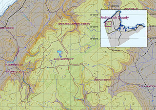
Eigg Mountain is high plateau, part of the highlands of Antigonish County, Nova Scotia, Canada.
References
- 1 2 Nova Scotia Department of Environment and Labour (2006). "Tobeatic Wilderness Area Management Plan" (PDF). Retrieved 30 December 2016.
- ↑ Smith, Andrew L. (2004). Paddling the Tobeatic. Nimbus. p. 370. ISBN 1-55109-492-4.
- ↑ SNBRA. "SNBRA's History" . Retrieved 15 July 2011.
- ↑ Nova Scotia Department of Natural Resources (2007). "Recovery Plan for Moose (Alces alces Americana) in Mainland Nova Scotia" (PDF). Nova Scotia Government. Retrieved 8 February 2016.