Lowman is a small rural census-designated place in Boise County, Idaho, United States. It is nestled along the north bank of the South Fork of the Payette River in the central part of the state, at an elevation of 3,800 feet (1,160 m) above sea level. As of the 2010 census, its population was 42.

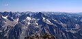
The Sawtooth Range is a mountain range of the Rocky Mountains in central Idaho, United States, reaching a maximum elevation of 10,751 feet (3,277 m) at the summit of Thompson Peak. It encompasses an area of 678 square miles (1,756 km2) spanning parts of Custer, Boise, Blaine, and Elmore counties, and is bordered to the east by the Sawtooth Valley. Much of the mountain range is within the Sawtooth Wilderness, part of the Sawtooth National Recreation Area and Sawtooth National Forest.
Little Regret Peak is an 11,090-foot elevation (3,380 m) mountain summit located in Custer County, Idaho, United States.

Doublespring Peak is an 11,611-foot elevation (3,539 m) mountain summit located in Custer County, Idaho, United States.

Boulder Peak is a 10,981-foot elevation (3,347 m) mountain summit located in Blaine County, Idaho, United States.

Easley Peak is an 11,108-foot elevation (3,386 m) mountain summit located on the common border that Blaine County shares with Custer County, in Idaho, United States.

Monte Verita is a 10,140-foot elevation (3,091 m) mountain summit located in Boise County, Idaho, United States.
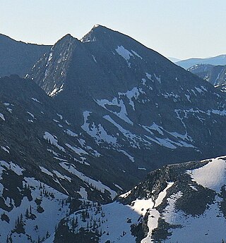
North Raker is a 9,970-foot elevation (3,039 m) mountain summit located in Boise County, Idaho, United States.

Freeman Peak is a 10,273-foot elevation (3,131 m) mountain summit located in Lemhi County, Idaho, United States.

Sawtooth Mountain is a 12,304-foot (3,750 m) summit on the boundary shared by Boulder County and Grand County, in Colorado, United States.

Sacajawea Peak is an 11,936-foot elevation (3,638 m) mountain summit in Custer County, Idaho, United States.
Ojibway Peak is a 7,303-foot-elevation (2,226-meter) mountain summit located on the border shared by Lincoln and Sanders counties in Montana.

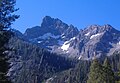
Grandjean Peak is a 9,180-foot-elevation (2,798-meter) mountain summit in Boise County, Idaho, United States.

The General is a 10,329-foot elevation (3,148 m) mountain summit in Custer County, Idaho, United States.

Scotchman Peak is a 7,018-foot-elevation (2,139 m) mountain summit in Bonner County, Idaho, United States.

Larkins Peak is a 6,661-foot-elevation (2,030 m) mountain summit in Shoshone County, Idaho, United States.

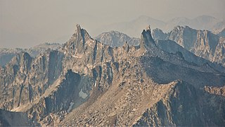
Finger of Fate is a 9,780-foot-elevation (2,981 m) pillar in Custer County, Idaho, United States.

Silver Peak is an 11,125-foot-elevation (3,391 m) mountain summit in Idaho, United States.

Silver Peak is an 11,167-foot-elevation (3,404 m) mountain summit in Idaho, United States.

Mystery Mountain is a 9,830-foot-elevation (2,996 m) summit in Custer County, Idaho, United States.