List of peaks of the Sawtooth Range (Idaho)

Last updated

This is a list of 147 of the peaks and climbing destinations in Idaho's Sawtooth Range.

Contents

147 Peaks and Climbing Destinations in the Sawtooth Mountains [1]
Rank Mountain Peak Elevation Prominence Isolation Location Easiest Route
1 Thompson Peak 10,751 ft
3277 m
2,431 ft
741 m
19.16 mi
30.8 km
44°08′30″N115°00′36″W / 44.141534°N 115.010013°W / 44.141534; -115.010013 (Thompson Peak) Class 3
2 Mount Cramer 10,715 ft
3266 m
1,716 ft
523 m
5.66 mi
9.11 km
44°00′40″N114°58′57″W / 44.011147°N 114.982491°W / 44.011147; -114.982491 (Mount Cramer) Class 3
3 Decker Peak 10,705 ft
3263 m
745 ft
227 m
2.31 mi
3.71 km
44°02′34″N114°58′04″W / 44.042773°N 114.967651°W / 44.042773; -114.967651 (Decker Peak) Class 3
4 Mickey's Spire 10,679 ft
3255 m
279 ft
85 m
0.24 mi
0.39 km
44°08′18″N115°00′44″W / 44.138368°N 115.012127°W / 44.138368; -115.012127 (Mickey's Spire) Class 4
5 Snowyside Peak 10,650 ft
3246 m
1,545 ft
471 m
5.07 mi
8.16 km
43°56′17″N114°58′17″W / 43.938155°N 114.971267°W / 43.938155; -114.971267 (Snowyside Peak) Class 3
6 Williams Peak 10,636 ft
3242 m
837 ft
255 m
0.78 mi
1.26 km
44°09′09″N115°00′21″W / 44.152471°N 115.005751°W / 44.152471; -115.005751 (Williams Peak) Class 3
7 Mount Carter 10,591 ft
3228 m
269 ft
82 m
0.32 mi
0.52 km
44°08′23″N115°01′06″W / 44.139835°N 115.018282°W / 44.139835; -115.018282 (Mount Carter) Class 2
8 Elk Peak 10,581 ft
3225 m
1,181 ft
360 m
2.88 mi
4.64 km
44°01′28″N115°02′14″W / 44.024403°N 115.037317°W / 44.024403; -115.037317 (Elk Peak) Class 4
9 Dave's Peak 10,577 ft
3224 m
359 ft
109 m
0.65 mi
1.05 km
44°01′10″N114°58′33″W / 44.01933°N 114.97587°W / 44.01933; -114.97587 (Dave's Peak) Class 4
10 Sevy Peak 10,479 ft
3194 m
745 ft
227 m
2.31 mi
3.71 km
44°01′29″N114°58′24″W / 44.024622°N 114.973355°W / 44.024622; -114.973355 (Sevy Peak) Class 5.4
11 Horstmann Peak 10,469 ft
3191 m
1,430 ft
436 m
1.85 mi
2.97 km
44°06′46″N115°00′08″W / 44.112641°N 115.002095°W / 44.112641; -115.002095 (Horstmann Peak) Class 3
12 Mount Limbert 10,384 ft
3165 m
262 ft
80 m
0.54 mi
0.87 km
44°08′00″N115°01′27″W / 44.133268°N 115.024098°W / 44.133268; -115.024098 (Mount Limbert) Class 3
13Peak 10,37510,374 ft
3162 m
315 ft
96 m
0.54 mi
0.87 km
44°02′05″N114°58′06″W / 44.0348°N 114.9684°W / 44.0348; -114.9684 (Peak 10,375) Class 3
14 Braxon Peak 10,354 ft
3156 m
554 ft
169 m
1.35 mi
2.18 km
44°05′36″N114°59′49″W / 44.093378°N 114.996857°W / 44.093378; -114.996857 (Braxon Peak) Class 3
15Peak 10,33610,335 ft
3150 m
unknownunknown Class 3
16 Moolack Mountain 10,331 ft
3149 m
790 ft
241 m
2.03 mi
3.27 km
44°07′48″N115°03′01″W / 44.13012°N 115.05033°W / 44.13012; -115.05033 (Moolack Mountain) Class 3
17 Mount Iowa 10,328 ft
3148 m
489 ft
149 m
0.65 mi
1.05 km
44°06′13″N114°59′53″W / 44.103632°N 114.998191°W / 44.103632; -114.998191 (Mount Iowa) Class 3
18 Merritt Peak 10,312 ft
3143 m
433 ft
132 m
1.07 mi
1.73 km
44°09′42″N115°01′25″W / 44.16160°N 115.02353°W / 44.16160; -115.02353 (Merritt Peak) Class 4
19 Baron Peak 10,299 ft
3139 m
817 ft
249 m
0.48 mi
0.78 km
44°07′25″N115°02′47″W / 44.123578°N 115.046409°W / 44.123578; -115.046409 (Baron Peak) Class 3
20 Red Bluff 10,269 ft
3130 m
212 ft
65 m
0.21 mi
0.34 km
44°01′39″N114°58′30″W / 44.0274°N 114.9750°W / 44.0274; -114.9750 (Red Bluff) Class 5.3
21 Perfect Peak 10,269 ft
3130 m
609 ft
186 m
1.77 mi
2.85 km
43°55′09″N114°56′50″W / 43.91918°N 114.94718°W / 43.91918; -114.94718 (Perfect Peak) Class 3
22 The Arrowhead 10,249 ft
3124 m
338 ft
103 m
0.65 mi
1.04 km
44°01′10″N114°58′34″W / 44.019344°N 114.97611°W / 44.019344; -114.97611 (The Arrowhead) Class 5.9
23 Packrat Peak 10,240 ft
3121 m
719 ft
219 m
2.38 mi
3.83 km
44°03′31″N115°02′37″W / 44.058562°N 115.043519°W / 44.058562; -115.043519 (Packrat Peak) Class 5.1
24 South Merritt Peak 10,240 ft
3121 m
unknownunknown Class 4
25 Mount Heyburn 10,226 ft
3117 m
561 ft
171 m
1.01 mi
1.62 km
44°06′04″N114°58′42″W / 44.100979°N 114.978317°W / 44.100979; -114.978317 (Mount Heyburn) Class 5.5
26 Vienna Peak 10,223 ft
3116 m
1,764 ft
538 m
6.68 mi
10.75 km
43°51′03″N114°51′12″W / 43.85080°N 114.85340°W / 43.85080; -114.85340 (Vienna Peak) Class 3
27 Redfish Peak 10,213 ft
3113 m
374 ft
114 m
1.23 mi
1.98 km
44°03′01″N114°59′24″W / 44.050203°N 114.990055°W / 44.050203; -114.990055 (Redfish Peak) Class 3
28 Payette Peak 10,210 ft
3112 m
371 ft
113 m
1.33 mi
2.14 km
43°59′32″N114°59′14″W / 43.99216°N 114.987318°W / 43.99216; -114.987318 (Payette Peak) Class 2
29 Cirque Lake Peak 10,210 ft
3112 m
728 ft
222 m
1.39 mi
2.23 km
44°04′41″N115°03′03″W / 44.077949°N 115.050727°W / 44.077949; -115.050727 (Cirque Lake Peak) Class 4
30 Parks Peak 10,279 ft
3133 m
919 ft
280 m
2.78 mi
4.47 km
43°58′01″N114°55′57″W / 43.96698°N 114.932446°W / 43.96698; -114.932446 (Parks Peak) Class 3
31Peak 10,20510,203 ft
3110 m
305 ft
93 m
0.71 mi
1.14 km
43°56′49″N114°58′44″W / 43.9469°N 114.9788°W / 43.9469; -114.9788 (Peak 10,205) Class 4
32 Warbonnet Peak 10,200 ft
3109 m
361 ft
110 m
0.17 mi
0.27 km
44°04′44″N115°03′14″W / 44.078865°N 115.053889°W / 44.078865; -115.053889 (Warbonnet Peak) Class 5.7
33 Mount Regan 10,190 ft
3106 m
1,709 ft
521 m
1.9 mi
3.06 km
44°09′35″N115°03′42″W / 44.15978°N 115.061586°W / 44.15978; -115.061586 (Mount Regan) Class 4
34 Mount Underhill 10,161 ft
3097 m
787 ft
240 m
0.4 mi
0.64 km
44°03′11″N115°02′46″W / 44.053144°N 115.046103°W / 44.053144; -115.046103 (Mount Underhill) Class 4
35Peak 10,16010,279 ft
3133 m
unknownunknown Class 3
36Peak 10,12910,128 ft
3087 m
949 ft
289 m
2.42 mi
3.89 km
43°52′12″N114°53′37″W / 43.8701°N 114.8936°W / 43.8701; -114.8936 (Peak 10,129) Class 2
37Peak 10,12710,125 ft
3086 m
unknownunknown Class 2
38 Imogene Peak 10,125 ft
3086 m
843 ft
257 m
1.83 mi
2.95 km
43°59′37″N114°56′07″W / 43.993476°N 114.935191°W / 43.993476; -114.935191 (Imogene Peak) Class 3
39 The Coffin 10,112 ft
3082 m
unknownunknown 44°01′44″N114°58′24″W / 44.02891°N 114.97332°W / 44.02891; -114.97332 (The Coffin) Class A1
40 Cirque Peak 10,105 ft
3080 m
unknownunknown Class 5.9 A1
41 Fishhook Spire 10,121 ft
3085 m
79 ft
24 m
0.32 mi
0.52 km
44°05′56″N114°59′53″W / 44.098965°N 114.997938°W / 44.098965; -114.997938 (Fishhook Spire) Class 5.5
42 Monte Verita 10,121 ft
3085 m
600 ft
183 m
0.57 mi
0.92 km
44°04′18″N115°02′36″W / 44.071629°N 115.043294°W / 44.071629; -115.043294 (Monte Verita) Class 4
43 Redfish Point 10,095 ft
3077 m
217 ft
66 m
0.43 mi
0.69 km
44°03′19″N114°59′43″W / 44.055168°N 114.995154°W / 44.055168; -114.995154 (Redfish Point) Class 4
44 Crown Point 10,085 ft
3074 m
40 ft
12 m
0.43 mi
0.69 km
44°09′38″N115°00′26″W / 44.16049°N 115.00728°W / 44.16049; -115.00728 (Crown Point) Class 3
45 Perforated Pinnacle 10,082 ft
3073 m
40 ft
12 m
0.58 mi
0.93 km
44°04′18″N115°02′36″W / 44.0716°N 115.0433°W / 44.0716; -115.0433 (Perforated Pinnacle) Class 4
46 Goat Perch 10,082 ft
3073 m
322 ft
98 m
0.6 mi
0.96 km
44°03′25″N114°58′57″W / 44.056921°N 114.982545°W / 44.056921; -114.982545 (Goat Perch) Class 5.7
47 Mayan Temple 10,079 ft
3072 m
279 ft
85 m
0.29 mi
0.46 km
44°03′40″N115°02′53″W / 44.061053°N 115.04816°W / 44.061053; -115.04816 (Mayan Temple) Class 4
48 Lions Head 10,075 ft
3071 m
unknownunknown Class 5.9
49 Reward Peak 10,075 ft
3071 m
230 ft
70 m
0.89 mi
1.43 km
44°02′07″N115°02′49″W / 44.035156°N 115.047068°W / 44.035156; -115.047068 (Reward Peak) Class 2
50 McDonald Peak 10,069 ft
3069 m
830 ft
253 m
1.93 mi
3.11 km
43°56′46″N114°54′23″W / 43.946195°N 114.906456°W / 43.946195; -114.906456 (McDonald Peak) Class 3
51 Glens Peak 10,052 ft
3064 m
853 ft
260 m
2.17 mi
3.49 km
43°56′59″N115°00′42″W / 43.949795°N 115.011625°W / 43.949795; -115.011625 (Glens Peak) Class 2
52Peak 10,05210,049 ft
3063 m
662 ft
202 m
1.02 mi
1.64 km
43°56′52″N114°57′20″W / 43.9477°N 114.9556°W / 43.9477; -114.9556 (Peak 10,052) Class 3
53 Tohobit Peak 10,046 ft
3062 m
886 ft
270 m
1.11 mi
1.79 km
44°05′30″N115°04′04″W / 44.091591°N 115.067646°W / 44.091591; -115.067646 (Tohobit Peak) Class 4
54 Leaning Tower of Pisa 10,039 ft
3060 m
unknownunknown Class A1
55 Schwartz Pinnacle 10,026 ft
3056 m
39 ft
12 m
0.4 mi
0.64 km
44°07′43″N115°01′09″W / 44.128709°N 115.019263°W / 44.128709; -115.019263 (Schwartz Pinnacle) Class 4
56Peak 10,02710,026 ft
3056 m
687 ft
209 m
1.15 mi
1.85 km
43°55′48″N114°54′40″W / 43.9299°N 114.9110°W / 43.9299; -114.9110 (Peak 10,027) Class 2
57 Tilted Slab Pinnacle 10,000 ft
3048 m
unknownunknown Class 5.3
58 Harriets Pinnacle 9,977 ft
3041 m
40 ft
12 m
5.4 mi
8.69 km
44°07′40″N115°00′49″W / 44.1277°N 115.0136°W / 44.1277; -115.0136 (Harriets Pinnacle) Class 5.4
59 Red Sentinel 9,977 ft
3041 m
40 ft
12 m
0.37 mi
0.6 km
44°04′43″N114°59′57″W / 44.0785°N 114.9993°W / 44.0785; -114.9993 (Red Sentinel) Class 5.4 A1
60 Twin 9,980 9,977 ft
3041 m
unknownunknown Class 5
61 Plummer Peak 9,977 ft
3041 m
1,083 ft
330 m
3.24 mi
5.22 km
43°56′45″N115°04′35″W / 43.945943°N 115.07645°W / 43.945943; -115.07645 (Plummer Peak) Class 3
62 North Raker 9,970 ft
3039 m
1,378 ft
420 m
3.7 mi
5.96 km
43°59′43″N115°06′20″W / 43.995288°N 115.105567°W / 43.995288; -115.105567 (North Raker) Class A2
63 Slide Peak 9,964 ft
3037 m
unknownunknown Class 3
64 Alpine Creek Lakes Peak 9,964 ft
3037 m
423 ft
129 m
1.51 mi
2.43 km
43°55′17″N114°59′27″W / 43.92151°N 114.99070°W / 43.92151; -114.99070 (Alpine Creek Lakes Peak) Class 2
65 Twin 9,960 9,957 ft
3035 m
unknownunknown Class 5
66 Abe's Armchair 9,957 ft
3035 m
39 ft
12 m
0.4 mi
0.64 km
43°52′00″N114°50′04″W / 43.86664°N 114.83448°W / 43.86664; -114.83448 (Abe's Armchair) Class 2
67 Benedict Peak 9,931 ft
3027 m
unknownunknown 43°58′12″N115°03′01″W / 43.97000°N 115.05040°W / 43.97000; -115.05040 (Benedict Peak) Class 3
68 Mattingly Peak 9,921 ft
3024 m
741 ft
226 m
2.15 mi
3.46 km
43°53′29″N115°00′14″W / 43.89140°N 115.00380°W / 43.89140; -115.00380 (Mattingly Peak) Class 3
69 Lunch Tower 9,902 ft
3018 m
40 ft
12 m
0.13 mi
0.21 km
44°04′08″N115°02′31″W / 44.0690°N 115.0420°W / 44.0690; -115.0420 (Lunch Tower) Class 4
70 Dinner Tower 9,902 ft
3018 m
40 ft
12 m
0.05 mi
0.08 km
44°04′12″N115°02′33″W / 44.0701°N 115.0425°W / 44.0701; -115.0425 (Dinner Tower) Class 5.2
71 La Fiamma 9,902 ft
3018 m
unknownunknown Class 5.6
72 El Capitan 9,902 ft
3018 m
436 ft
133 m
1.41 mi
2.27 km
43°56′28″N114°56′02″W / 43.941089°N 114.933829°W / 43.941089; -114.933829 (El Capitan) Class 3
73 Mount Ebert 9,879 ft
3011 m
679 ft
207 m
1.31 mi
2.11 km
44°06′33″N115°01′46″W / 44.109065°N 115.0294°W / 44.109065; -115.0294 (Mount Ebert) Class 5.4
74 South Raker 9,879 ft
3011 m
118 ft
36 m
0.19 mi
0.3 km
43°59′35″N115°06′13″W / 43.99302°N 115.103474°W / 43.99302; -115.103474 (South Raker) Class 4
75 Mount Bruce 9,872 ft
3009 m
120 ft
37 m
0.72 mi
1.16 km
44°07′38″N115°00′38″W / 44.12736°N 115.01052°W / 44.12736; -115.01052 (Mount Bruce) Class 4
76 Little Decker 9,869 ft
3008 m
650 ft
198 m
1.47 mi
2.37 km
44°03′58″N114°57′22″W / 44.0662°N 114.9561°W / 44.0662; -114.9561 (Little Decker) Class 3
77 Elephants Perch 9,967 ft
3038 m
249 ft
76 m
0.65 mi
1.04 km
44°04′22″N114°58′07″W / 44.072733°N 114.968686°W / 44.072733; -114.968686 (Elephants Perch) Class 3
78 Rotten Monolith 9,869 ft
3008 m
160 ft
49 m
0.2 mi
0.32 km
44°05′45″N114°59′39″W / 44.0957°N 114.9942°W / 44.0957; -114.9942 (Rotten Monolith) Class A3
79 Alpine Peak 9,862 ft
3006 m
741 ft
226 m
0.99 mi
1.6 km
44°10′17″N115°03′00″W / 44.171406°N 115.049865°W / 44.171406; -115.049865 (Alpine Peak) Class 2
80 McGowan Peak 9,859 ft
3005 m
1,099 ft
335 m
3.25 mi
5.23 km
44°12′45″N115°04′54″W / 44.212635°N 115.081547°W / 44.212635; -115.081547 (McGowan Peak) Class 3
81 Mount Everly 9,852 ft
3003 m
1,214 ft
370 m
1.14 mi
1.83 km
43°57′29″N115°05′31″W / 43.957951°N 115.092005°W / 43.957951; -115.092005 (Mount Everly) Class 3
82 Old Decker 9,846 ft
3001 m
427 ft
130 m
0.7 mi
1.13 km
44°03′23″N114°57′11″W / 44.0563°N 114.9530°W / 44.0563; -114.9530 (Old Decker) Class 4
83 Chipmunk Perch 9,839 ft
2999 m
80 ft
24 m
0.25 mi
0.4 km
44°03′37″N114°58′53″W / 44.0604°N 114.9815°W / 44.0604; -114.9815 (Chipmunk Perch) Class 5.9
84 El Pima 9,836 ft
2998 m
236 ft
72 m
0.6 mi
0.97 km
44°05′06″N115°02′37″W / 44.084985°N 115.043538°W / 44.084985; -115.043538 (El Pima) Class A1
85 Mystery Mountain 9,820 ft
2993 m
600 ft
183 m
0.8 mi
1.29 km
44°12′21″N115°04′06″W / 44.20582°N 115.06840°W / 44.20582; -115.06840 (Mystery Mountain) Class 2
86 Blacknose Mountain 9,505 ft
2897 m
542 ft
165 m
1.5 mi
2.41 km
43°58′28″N115°06′48″W / 43.9745°N 115.1133°W / 43.9745; -115.1133 (Blacknose Mountain) Class 3
87 Damocles 9,800 ft
2987 m
unknownunknown Class 5.3
88Peak 9,9789,797 ft
2986 m
378 ft
115 m
0.49 mi
0.79 km
43°57′10″N115°04′27″W / 43.9529°N 115.0743°W / 43.9529; -115.0743 (Peak 9,978) Class 3
89 Monte Verita South 9,769 ft
2978 m
171 ft
52 m
0.44 mi
0.71 km
44°04′02″N115°02′13″W / 44.067196°N 115.036897°W / 44.067196; -115.036897 (Monte Verita South) Class 3
90 Garden Peak 9,764 ft
2976 m
unknownunknown 44°03′17″N115°05′17″W / 44.05486°N 115.08798°W / 44.05486; -115.08798 (Garden Peak) Class 3
91 Pyramid Peak 9,760 ft
2975 m
unknownunknown Class 5.8
92 Finger of Fate 9,757 ft
2974 m
95 ft
29 m
0.53 mi
0.85 km
44°01′32″N114°57′46″W / 44.025561°N 114.962873°W / 44.025561; -114.962873 (Finger of Fate) Class 5.7
93Peak 9,7379,734 ft
2967 m
637 ft
194 m
2.49 mi
4.01 km
43°55′13″N115°02′28″W / 43.9204°N 115.0411°W / 43.9204; -115.0411 (Peak 9,737) Class 5.8
94 Grand Mogul 9,734 ft
2967 m
335 ft
102 m
0.95 mi
1.53 km
44°04′47″N114°57′36″W / 44.079759°N 114.960053°W / 44.079759; -114.960053 (Grand Mogul) Class 3
95Peak 9,7309,728 ft
2965 m
unknownunknown Class 5.8
96 Eagle's Beak 9,728 ft
2965 m
unknownunknown 44°04′37″N115°00′43″W / 44.07683°N 115.01192°W / 44.07683; -115.01192 (Eagle's Beak) Class 5.3
97Peak 9,7229,760 ft
2975 m
462 ft
141 m
0.69 mi
1.11 km
43°59′02″N115°06′32″W / 43.9839°N 115.1089°W / 43.9839; -115.1089 (Peak 9,722) Class ?
98 Peak 9,709 9,721 ft
2963 m
unknownunknown Class 2
99 Browns Peak 9,705 ft
2958 m
765 ft
233 m
2.66 mi
4.28 km
43°56′03″N115°08′02″W / 43.934238°N 115.134019°W / 43.934238; -115.134019 (Browns Peak) Class 3
100 Arvals Peak 9,705 ft
2958 m
unknownunknown 43°57′54″N115°07′12″W / 43.96510°N 115.11990°W / 43.96510; -115.11990 (Arvals Peak) Class 3
101 Mount Alpen 9,705 ft
2958 m
40 ft
12 m
0.2 mi
0.32 km
Class 3
102 Breakfast Tower 9,705 ft
2958 m
40 ft
12 m
0.2 mi
0.32 km
44°04′06″N115°02′28″W / 44.0682°N 115.0411°W / 44.0682; -115.0411 (Breakfast Tower) Class A2
103Peak 9,7049,701 ft
2957 m
484 ft
148 m
0.73 mi
1.17 km
43°57′54″N115°07′12″W / 43.9651°N 115.1200°W / 43.9651; -115.1200 (Peak 9,704) Class 3
104 Quartzite Peak 9,682 ft
2951 m
382 ft
116 m
0.42 mi
0.68 km
44°05′02″N114°59′37″W / 44.0839°N 114.9936°W / 44.0839; -114.9936 (Quartzite Peak) Class 4
105 Silicon Tower 9,678 ft
2950 m
unknownunknown Class 5.9
106 Flat Top Mountain 9,665 ft
2946 m
763 ft
233 m
1.16 mi
1.87 km
43°55′03″N115°08′05″W / 43.91760°N 115.13480°W / 43.91760; -115.13480 (Flat Top Mountain) Class 3
107 Peak 9,709 9,626 ft
2934 m
unknownunknown Class 3
108Blizzard Mountain9,606 ft
2928 m
1,228 ft
374 m
3.24 mi
5.21 km
43°52′29″N115°04′42″W / 43.87466°N 115.07845°W / 43.87466; -115.07845 (Blizzard Mountain) Class 3
109 Cony Peak 9,606 ft
2928 m
266 ft
81 m
0.57 mi
0.92 km
44°03′47″N115°05′23″W / 44.06309°N 115.08970°W / 44.06309; -115.08970 (Cony Peak) Class 3
110 Mount Bush 9,600 ft
2926 m
200 ft
61 m
0.78 mi
1.26 km
44°07′40″N115°00′13″W / 44.127819°N 115.003591°W / 44.127819; -115.003591 (Mount Bush) Class 4
111 Cirque Lake Tower 9,600 ft
2926 m
unknownunknown Class 5.4
112 Nahneke Mountain 9,583 ft
2921 m
482 ft
147 m
1.68 mi
2.7 km
43°53′36″N115°08′00″W / 43.89320°N 115.13340°W / 43.89320; -115.13340 (Nahneke Mountain) Class 3
113 West Nahneke 9,564 ft
2915 m
864 ft
263 m
0.5 mi
0.8 km
43°53′39″N115°08′36″W / 43.8941°N 115.1434°W / 43.8941; -115.1434 (West Nahneke) Class ?
114 Eagle Perch 9,560 ft
2914 m
157 ft
48 m
0.2 mi
0.32 km
44°03′35″N114°59′00″W / 44.059701°N 114.983351°W / 44.059701; -114.983351 (Eagle Perch) Class 5.3
115 Scenic Peak 9,554 9,554 ft
2912 m
454 ft
138 m
0.64 mi
1.03 km
43°54′31″N115°08′18″W / 43.9087°N 115.1382°W / 43.9087; -115.1382 (Scenic Peak 9,554) Class 3
116 Pinochot Mountain 9,501 ft
2896 m
unknownunknown Class 2
117 Dessert Tower 9,498 ft
2895 m
unknownunknown Class 4
118 South Alpine Peak 9,485 ft
2891 m
386 ft
118 m
0.9 mi
1.45 km
44°09′33″N115°02′28″W / 44.1593°N 115.0412°W / 44.1593; -115.0412 (South Alpine Peak) Class 2
119Peak 9,4829,482 ft
2890 m
unknownunknown Class ?
120 Stephens Spire 9,439 ft
2877 m
unknownunknown Class 5.1
121 Rothorn Spire 9,439 ft
2877 m
320 ft
98 m
0.8 mi
1.29 km
44°05′57″N115°01′17″W / 44.0991°N 115.0214°W / 44.0991; -115.0214 (Rothorn Spire) Class 5.7
122Split Tooth9,367 ft
2855 m
120 ft
37 m
0.66 mi
1.06 km
44°05′28″N114°59′02″W / 44.0910°N 114.9839°W / 44.0910; -114.9839 (Split Tooth) Class 5.7
123Peak 9,3679,367 ft
2855 m
867 ft
264 m
2.19 mi
3.52 km
43°51′23″N114°47′36″W / 43.85640°N 114.79320°W / 43.85640; -114.79320 (Peak 9,367) Class 3
124 Greylock Mountain 9,364 ft
2854 m
663 ft
202 m
2.28 mi
3.67 km
43°50′39″N115°05′45″W / 43.84411°N 115.09581°W / 43.84411; -115.09581 (Greylock Mountain) Class 3
125 Grand Aiguille 9,344 ft
2848 m
unknownunknown Class 5.4
126 Ed-Da-How Spire 9,331 ft
2844 m
73 ft
22 m
0.39 mi
0.63 km
44°06′13″N115°01′34″W / 44.1036°N 115.0260°W / 44.1036; -115.0260 (Ed-Da-How Spire) Class 5.2
127 Kelly Point 9,321 ft
2841 m
unknownunknown 44°15′54″N115°09′52″W / 44.26487°N 115.16448°W / 44.26487; -115.16448 (Kelly Point) Class 2
128 Chockstone Peak 9,318 ft
2840 m
220 ft
67 m
0.88 mi
1.42 km
44°03′52″N114°59′49″W / 44.0644°N 114.9969°W / 44.0644; -114.9969 (Chockstone Peak) Class 4
129 Rainy Day Pinnacle 9,281 ft
2829 m
unknownunknown Class 5.10
130 Blue Rock Dome 9,242 ft
2817 m
unknownunknown Class 5.10
131 Baron Spire 9,209 ft
2807 m
unknownunknown 44°05′34″N115°02′20″W / 44.09270°N 115.03900°W / 44.09270; -115.03900 (Baron Spire) Class 5.9 A1
132 Black Aiguille 9,196 ft
2803 m
unknownunknown Class 5.2
133 Small Aiguille 9,157 ft
2791 m
unknownunknown Class 5.4
134 Observation Peak 9,150 ft
2789 m
709 ft
216 m
2.5 mi
4.02 km
44°10′15″N115°06′34″W / 44.170929°N 115.109417°W / 44.170929; -115.109417 (Observation Peak) Class 1
135 Grandjean East 9,144 ft
2787 m
679 ft
207 m
2.52 mi
4.05 km
44°06′46″N115°05′49″W / 44.11280°N 115.09690°W / 44.11280; -115.09690 (Grandjean East) Class 5.7
136 Grandjean West 9,104 ft
2775 m
unknownunknown Class 3
137 King Spire 8,980 ft
2737 m
unknownunknown Class 5.10R
138 Copper Mountain 8,967 ft
2733 m
426 ft
130 m
2 mi
3.22 km
44°19′55″N115°12′04″W / 44.33200°N 115.20100°W / 44.33200; -115.20100 (Copper Mountain) Class 2
139 Baron Falls Tower 8,960 ft
2731 m
unknownunknown Class 5.10
140Peak 8,9528,950 ft
2728 m
332 ft
101 m
0.66 mi
1.06 km
43°54′33″N115°07′30″W / 43.9091°N 115.1249°W / 43.9091; -115.1249 (Peak 8,952) Class 5.?
141Peak 8,9018,901 ft
2713 m
304 ft
93 m
0.98 mi
1.58 km
44°01′04″N115°05′05″W / 44.0178°N 115.0846°W / 44.0178; -115.0846 (Peak 8,901) Class ?
142 Dark Knight Spire 8,839 ft
2694 m
unknownunknown Class 5.9+
143 Mount Zumwalt 8,816 ft
2687 m
956 ft
291 m
2.73 mi
4.39 km
44°11′59″N115°12′06″W / 44.1997°N 115.2018°W / 44.1997; -115.2018 (Mount Zumwalt) Class 2
144 Serf Spire 8,773 ft
2674 m
unknownunknown Class 5.6
145 The Jester 8,760 ft
2670 m
unknownunknown Class 5.9
146 Queen Spire 8,491 ft
2588 m
unknownunknown Class 5.8
147 Super Slab 7,861 ft
2396 m
unknownunknown 44°05′09″N114°58′48″W / 44.08570°N 114.97990°W / 44.08570; -114.97990 (Super Slab) Class 5.5
148 Payette Pinnacle 7,254 ft
2211 m
unknownunknown Class 5.5

See also

Notes

1. ^ Baron Spire collapsed following a 4.2 magnitude earthquake in August 2020. [2]

Related Research Articles

<span class="mw-page-title-main">Sawtooth Range (Idaho)</span> Mountain range in Idaho, United States

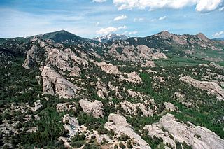
The Sawtooth Range is a mountain range of the Rocky Mountains in central Idaho, United States, reaching a maximum elevation of 10,751 feet (3,277 m) at the summit of Thompson Peak. It encompasses an area of 678 square miles (1,756 km2) spanning parts of Custer, Boise, Blaine, and Elmore counties, and is bordered to the east by the Sawtooth Valley. Much of the mountain range is within the Sawtooth Wilderness, part of the Sawtooth National Recreation Area and Sawtooth National Forest.

Mount Cramer, at 10,716 feet (3,266 m) is the second highest peak in the Sawtooth Range of Idaho. The summit of Mount Cramer is located on the border of Custer and Boise Counties. The peak is the highest point in Boise County. Mount Cramer is also located within the Sawtooth Wilderness portion of the Sawtooth National Recreation Area. The town of Stanley, Idaho is almost 14 miles (23 km) from Mount Cramer, while the area known as Sawtooth City is nearly 12 miles (19 km) from Mount Cramer. The west side of Mount Cramer drains into the South Fork of the Payette River, while the east side drains to the Salmon River.

<span class="mw-page-title-main">Mount Heyburn</span>

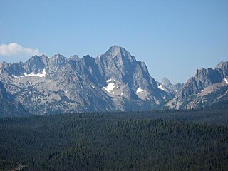
Mount Heyburn, at 10,229 feet (3,118 m) is one of the many 10,000-foot (3,050 m) peaks in the Sawtooth Range of central Idaho. Mount Heyburn is located in Custer County and within the Sawtooth Wilderness portion of the Sawtooth National Recreation Area. The town of Stanley is located eight miles (13 km) north-northeast of Mount Heyburn. Grand Mogul, 9,733 ft (2,967 m), and Mount Heyburn are the two signature peaks that frame the southwest end of Redfish Lake ; all are in the Salmon River watershed.

<span class="mw-page-title-main">Cache Peak (Idaho)</span>

Cache Peak, at 10,339 feet (3,151 m) above sea level, is the highest peak in the Albion Mountains of Cassia County in Southern Idaho. Cache Peak is located in the central part of the range southeast of Oakley and north of Almo in the Albion Division of the Minidoka Ranger District of Sawtooth National Forest.

Mount Independence is the second highest peak in the Albion Mountains of Idaho. The peak is located in Sawtooth National Forest and Cassia County. It is located about 1 mi (1.6 km) northwest of Cache Peak. The Independence Lakes are located in the basin to the east of the peak. Mount Independence supports one of the three populations of Cymopterus davisii, a plant that is endemic to the Albion Mountains. The Mount Independence population is considered a single population with Cache Peak. Mount Independence is 9,950 feet (3,030 m) above sea level.

<span class="mw-page-title-main">Decker Peak</span> Mountain in Idaho, USA

Decker Peak, at 10,704 feet (3,263 m) above sea level is the third highest peak in the Sawtooth Range of Idaho. The peak is located in the Sawtooth Wilderness of Sawtooth National Recreation Area in Custer County. The peak is located 2.3 mi (3.7 km) south-southwest of Mount Cramer, its line parent. It is the 204th highest peak in Idaho.

<span class="mw-page-title-main">Mickey's Spire</span>

Mickey's Spire, at 10,680 feet (3,260 m) above sea level is the fourth highest peak in the Sawtooth Range of Idaho. The peak is located in the Sawtooth Wilderness of Sawtooth National Recreation Area in Custer County. The peak is located 0.24 mi (0.39 km) south-southwest of Thompson Peak, its line parent. It is the 206th highest peak in Idaho.

<span class="mw-page-title-main">Snowyside Peak</span>

Snowyside Peak, at 10,651 feet (3,246 m) above sea level, is the fifth-highest peak in the Sawtooth Range of the U.S. state of Idaho. The peak is located in the Sawtooth Wilderness of Sawtooth National Recreation Area at the intersection of Blaine, Custer County, and Elmore counties. It is the highest point in Elmore County. The peak is located 5.1 miles (8.2 km) south of Mount Cramer, its line parent. It is the 217th-highest peak in Idaho.

<span class="mw-page-title-main">Mount Carter (Idaho)</span>

Mount Carter, at 10,590 feet (3,230 m) above sea level is the seventh highest peak in the Sawtooth Range of Idaho. The peak is located in the Sawtooth Wilderness of Sawtooth National Recreation Area on the border of Boise and Custer counties. The peak is located 0.32 mi (0.51 km) northwest of Mickey's Spire, its line parent, and 0.43 mi (0.69 km) west of Thompson Peak, the highest point in the range.

<span class="mw-page-title-main">Mount Limbert</span>

Mount Limbert, at 10,385 feet (3,165 m) above sea level is the 12th highest peak in the Sawtooth Range of Idaho. The peak is located in the Sawtooth Wilderness of Sawtooth National Recreation Area on the border of Boise and Custer counties. The peak is located 0.54 mi (0.87 km) southwest of Mount Carter, its line parent.

<span class="mw-page-title-main">Moolack Mountain (Idaho)</span>

Moolack Mountain, also sometimes referred to as Baron Peak North, at 10,330 feet (3,150 m) above sea level is a peak in the Sawtooth Range of Idaho. The peak is located in the Sawtooth Wilderness of Sawtooth National Recreation Area in Boise County. The peak is located 1.3 mi (2.1 km) west of Mount Limbert, its line parent, and 0.5 mi (0.80 km) northwest of Baron Peak.

<span class="mw-page-title-main">Baron Peak</span>

Baron Peak, at 10,297 feet (3,139 m) above sea level is a peak in the Sawtooth Range of Idaho. The peak is located in the Sawtooth Wilderness of Sawtooth National Recreation Area on the border of Boise and Custer counties. The peak is located 0.5 mi (0.80 km) southeast of Moolack Mountain, its line parent.

<span class="mw-page-title-main">Elk Peak (Idaho)</span>

Elk Peak, at 10,582 feet (3,225 m) above sea level, is the eighth-highest peak in the Sawtooth Range of the U.S. state of Idaho. The peak is located in the Sawtooth Wilderness of Sawtooth National Recreation Area in Boise and Custer counties. The peak is located 2.88 mi (4.63 km) west-northwest of Mount Cramer, its line parent. It is the 240th-highest peak in Idaho and 0.5 mi (0.80 km) south-southeast of Reward Peak.

<span class="mw-page-title-main">Horstmann Peak</span>

Horstmann Peak, at 10,475 feet (3,193 m) above sea level is the 11th highest peak in the Sawtooth Range of Idaho. The peak is located in the Sawtooth Wilderness of Sawtooth National Recreation Area in Custer County. The peak is located 1.85 mi (2.98 km) south-southeast of Mickey's Spire, its line parent. It is also 2.0 mi (3.2 km) south of Thompson Peak and 1.35 mi (2.17 km) north of Braxon Peak.

<span class="mw-page-title-main">Sevy Peak</span>

Sevy Peak, at 10,480 feet (3,190 m) above sea level is a peak in the Sawtooth Range of Idaho. The peak is located in the Sawtooth Wilderness of Sawtooth National Recreation Area in Custer County. The peak is located 0.39 mi (0.63 km) north-northeast of Dave's Peak, its line parent. It is 1.3 mi (2.1 km) south of Decker Peak.

<span class="mw-page-title-main">Braxon Peak</span>

Braxon Peak, at 10,353 feet (3,156 m) above sea level is a peak in the Sawtooth Range of Idaho. The peak is located in the Sawtooth Wilderness of Sawtooth National Recreation Area on the border of Boise and Custer counties. The peak is located 1.36 mi (2.19 km) south of Mount Cramer, its line parent. It is also about 1.2 mi (1.9 km) south-southwest of Mount Heyburn. Braxon Lake is just southwest of the peak.

<span class="mw-page-title-main">Packrat Peak</span>

Packrat Peak, at 10,240 feet (3,120 m) above sea level is a peak in the Sawtooth Range of Idaho. The peak is located in the Sawtooth Wilderness of Sawtooth National Recreation Area on the border of Boise and Custer counties. The peak is located 2.38 mi (3.83 km) north of Elk Peak, its line parent. Warbonnet and Little Warbonnet lakes are in the basin north of the peak.

Mount Iowa, at 10,327 feet (3,148 m) above sea level is a peak in the Sawtooth Range of Idaho. The peak is located in the Sawtooth Wilderness of Sawtooth National Recreation Area in Custer County. The peak is located 0.65 mi (1.05 km) south-southeast of Horstmann Peak, its line parent. It is about 0.7 mi (1.1 km) north of Braxon Peak and 1.1 mi (1.8 km) west of Mount Heyburn.

Dave's Peak, at 10,579 feet (3,224 m) above sea level is an unofficially named peak that is the ninth highest peak in the Sawtooth Range of Idaho. The peak is located in the Sawtooth Wilderness of Sawtooth National Recreation Area in Custer County. The peak is located 0.65 mi (1.05 km) northeast of Mount Cramer, its line parent. Profile and Lucille lakes are southeast of the peak, while Upper, Middle, and Lower Cramer lakes are northwest of the peak. Dave's Peak is south-southwest of Sevy Peak.

Merritt Peak, at 10,312 feet (3,143 m) above sea level is a peak in the Sawtooth Range of Idaho. The peak is located in the Sawtooth Wilderness of Sawtooth National Recreation Area in Custer County. The peak is located 1.08 mi (1.74 km) northwest of Williams Peak, its line parent. It is south-southwest of Goat Lake

References

Map all coordinates using: OpenStreetMap
Download coordinates as: KML
  1. Summitpost.org - The Complete Sawtooths List. Retrieved 21 November 2011.
  2. Wehner, Mike (August 12, 2020). "Video shows a huge mountain come crashing down after an earthquake in Idaho". BGR.