Urbancrest, Ohio | |
---|---|
Coordinates: 39°54′06″N83°05′10″W / 39.90167°N 83.08611°W | |
Country | United States |
State | Ohio |
County | Franklin |
Area | |
• Total | 0.59 sq mi (1.52 km2) |
• Land | 0.59 sq mi (1.52 km2) |
• Water | 0.00 sq mi (0.00 km2) |
Elevation | 830 ft (250 m) |
Population (2020) | |
• Total | 1,031 |
• Density | 1,759.39/sq mi (679.44/km2) |
Time zone | UTC-5 (Eastern (EST)) |
• Summer (DST) | UTC-4 (EDT) |
ZIP code | 43123 |
Area code | 614 |
FIPS code | 39-79100 [3] |
GNIS feature ID | 2400032 [2] |
Urbancrest is a village in Franklin County, Ohio, United States. The population was 1,031 at the 2020 census. Urbancrest is in the South-Western City Schools District.
According to the United States Census Bureau, the village has a total area of 0.60 square miles (1.55 km2), all land. [4]
Urbancrest borders Columbus, Ohio and Grove City, Ohio.
It is entirely located in the South-Western City School District. [5]
Urbancrest was first settled in 1889, with the first church, later known as Union Baptist Church, being founded in 1892. The village was then incorporated in 1948. In 1971, Urbancrest elected Ellen Walker Craig-Jones as mayor, making her the first African-American female mayor elected in the United States of America. [6]
Census | Pop. | Note | %± |
---|---|---|---|
1950 | 823 | — | |
1960 | 1,029 | 25.0% | |
1970 | 754 | −26.7% | |
1980 | 880 | 16.7% | |
1990 | 862 | −2.0% | |
2000 | 868 | 0.7% | |
2010 | 960 | 10.6% | |
2020 | 1,031 | 7.4% | |
U.S. Decennial Census [7] 2020 [8] |
Race / Ethnicity (NH = Non-Hispanic) | Pop 2000 [9] | Pop 2010 [10] | Pop 2020 [11] | % 2000 | % 2010 | 2020 |
---|---|---|---|---|---|---|
White alone (NH) | 194 | 231 | 255 | 22.35% | 24.06% | 24.73% |
Black or African American alone (NH) | 503 | 523 | 599 | 57.95% | 54.48% | 58.10% |
Native American or Alaska Native alone (NH) | 4 | 1 | 0 | 0.46% | 0.10% | 0.00% |
Asian alone (NH) | 122 | 28 | 18 | 14.06% | 2.92% | 1.75% |
Pacific Islander alone (NH) | 0 | 84 | 2 | 0.00% | 8.75% | 0.19% |
Other race alone (NH) | 3 | 6 | 8 | 0.35% | 0.31% | 0.78% |
Mixed race or Multiracial (NH) | 30 | 54 | 60 | 3.46% | 5.63% | 5.82% |
Hispanic or Latino (any race) | 12 | 36 | 89 | 1.38% | 3.75% | 8.63% |
Total | 868 | 960 | 1,031 | 100.00% | 100.00% | 100.00% |
As of the census [12] of 2010, there were 960 people, 337 households, and 237 families living in the village. The population density was 1,600.0 inhabitants per square mile (617.8/km2). There were 367 housing units at an average density of 611.7 per square mile (236.2/km2). The racial makeup of the village was 26.4% White, 55.1% African American, 0.1% Native American, 2.9% Asian, 8.8% Pacific Islander, 0.9% from other races, and 5.8% from two or more races. Hispanic or Latino of any race were 3.8% of the population.
There were 337 households, of which 46.6% had children under the age of 18 living with them, 29.4% were married couples living together, 33.2% had a female householder with no husband present, 7.7% had a male householder with no wife present, and 29.7% were non-families. 25.8% of all households were made up of individuals, and 9.5% had someone living alone who was 65 years of age or older. The average household size was 2.85 and the average family size was 3.41.
The median age in the village was 25.3 years. 38.1% of residents were under the age of 18; 11.3% were between the ages of 18 and 24; 23.6% were from 25 to 44; 19.7% were from 45 to 64; and 7.4% were 65 years of age or older. The gender makeup of the village was 45.0% male and 55.0% female.
As of the census [3] of 2000, there were 868 people, 321 households, and 234 families living in the village. The population density was 1,962.0 inhabitants per square mile (757.5/km2). There were 347 housing units at an average density of 784.4 per square mile (302.9/km2). The racial makeup of the village was 23.50% White, 57.95% African American, 0.46% Native American, 14.06% Asian, 0.58% from other races, and 3.46% from two or more races. Hispanic or Latino of any race were 1.38% of the population.
There were 321 households, out of which 47.4% had children under the age of 18 living with them, 24.6% were married couples living together, 42.4% had a female householder with no husband present, and 26.8% were non-families. 24.3% of all households were made up of individuals, and 10.3% had someone living alone who was 65 years of age or older. The average household size was 2.70 and the average family size was 3.20.
In the village, the population was spread out, with 41.8% under the age of 18, 9.0% from 18 to 24, 22.4% from 25 to 44, 16.9% from 45 to 64, and 9.9% who were 65 years of age or older. The median age was 24 years. For every 100 females there were 72.6 males. For every 100 females age 18 and over, there were 62.4 males.
The median income for a household in the village was $20,333, and the median income for a family was $23,929. Males had a median income of $27,500 versus $25,268 for females. The per capita income for the village was $10,003. About 30.6% of families and 32.7% of the population were below the poverty line, including 44.7% of those under age 18 and 15.6% of those age 65 or over.
Hillsdale is a village in St. Louis County, Missouri, United States. Greenwood Cemetery is located in Hillsdale. The population was 1,478 at the 2010 census.
Fort Shawnee is census-designated place (CDP) in Allen County, Ohio, United States. The population was 6,263 at the 2020 census. It is included in the Lima, Ohio Metropolitan Statistical Area. Fort Shawnee is adjacent to the city of Lima and the village of Cridersville in Auglaize County. In 2012, village residents voted to disincorporate the village. According to the United States Census Bureau, the village had a total area of 7.25 square miles (18.78 km2), of which 7.21 square miles (18.67 km2) is land and 0.04 square miles (0.10 km2) is water.
Aberdeen is a village in Huntington Township, Brown County, Ohio, United States, along the Ohio River 50 miles (80 km) southeast of Cincinnati. The population was 1,515 at the 2020 census.
Donnelsville is a village in Clark County, Ohio, United States. The population was 255 at the 2020 census. It is part of the Springfield, Ohio Metropolitan Statistical Area.
Woodmere is a village in Cuyahoga County, Ohio, United States. As of the 2020 census, Woodmere had a population of 641 residents. An eastern suburb of Cleveland, it is part of the Cleveland metropolitan area.
Wayne Lakes is a village in Darke County, Ohio, United States. The population was 693 at the 2020 census.
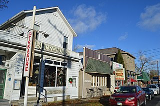
Millersport is a village in Fairfield County, Ohio, United States. The population was 978 at the 2020 census. Millersport is most notable as the home of the Sweet Corn Festival, which is held in Millersport annually during the first week of September.
Cleves is a village in Miami Township, Hamilton County, Ohio, United States. Located along the Ohio River, it is a western suburb of Cincinnati. The population was 3,414 at the 2020 census.
Hanover is a village in Licking County, Ohio, United States. The population was 1,270 at the 2020 census. The village lies along Ohio State Route 16.
Hartford is a village in the township of the same name in Licking County, Ohio, United States. The population was 404 at the 2020 census.
Kirkersville is a village in Licking County, Ohio, United States, along the South Fork of the Licking River. The population was 471 at the 2020 census.
Haviland is a village in Paulding County, Ohio, United States. The population was 160 at the 2020 census.
Hartville is a village in northern Stark County, Ohio, United States. The population was 3,329 at the 2020 census. It is part of the Canton–Massillon metropolitan area. Hartville lies halfway between Akron and Canton at the intersection of State Routes 43 and 619.
Limaville is a census-designated place (CDP) and former village in Stark County, Ohio, United States. The population was 151 at the 2020 census. It is part of the Canton–Massillon Metropolitan Statistical Area.
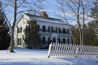
Boston Heights is a village in northern Summit County, Ohio, United States. The population was 1,402 at the 2020 census. It is part of the Akron metropolitan area. Boston Heights is home to the headquarters of Arhaus, a major home furnishings retailer.
Port Washington is a village in Tuscarawas County, Ohio, United States. The population was 548 at the 2020 census.
Apple Creek is a village in East Union Township, Wayne County, Ohio, United States. The population was 1,188 at the 2020 census.
Bairdstown is a village in Wood County, Ohio, United States. The population was 115 at the 2020 census.
Risingsun is a village in Wood County, Ohio, United States. The population was 541 at the 2020 census.
Cincinnati is a city in Ohio, United States.