Daggett County is a county in the northeastern corner of the U.S. state of Utah. As of the 2020 United States Census, the population was 935, making it the least populous county in Utah. Its county seat is Manila. The county was named for Ellsworth Daggett, the first surveyor-general of Utah. The small community of Dutch John, located near the state line with Colorado and Wyoming, became an incorporated town in January 2016.

Uintah County is a county in the U.S. state of Utah. As of the 2020 United States Census the population was 35,620. Its county seat and largest city is Vernal. The county was named for the portion of the Ute Indian tribe that lived in the basin.
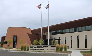
Montezuma County is a county located in the southwest corner of the U.S. state of Colorado. As of the 2020 census, the population was 25,849. The county seat is Cortez.
Moffat County is a county located in the U.S. state of Colorado. As of the 2020 census, the population was 13,292. The county seat is Craig. With an area of 4,751 square miles, it is the second-largest county by area in Colorado, behind Las Animas County.

Mount Adams is a 3,520-foot-tall (1,070 m) mountain located in Essex County of New York. Atop the mountain is the Mount Adams Fire Observation Station, added to the National Register of Historic Places in 2006.

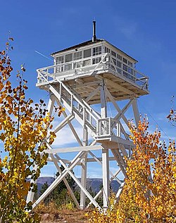
A fire lookout is a person assigned the duty to look for fire from atop a building known as a fire lookout tower. These towers are used in remote areas, normally on mountain tops with high elevation and a good view of the surrounding terrain, to spot smoke caused by a wildfire.
Brown's Park or Browns Park, originally called Brown's Hole, is an isolated mountain valley along the Green River in Moffat County, Colorado and Daggett County, Utah in the United States. The valley begins in far eastern Utah, approximately 25 miles (40 km) downstream from Flaming Gorge Dam, and follows the river downstream into Colorado, ending at the Gates of Lodore in Dinosaur National Monument. Known as a haven for outlaws such as Butch Cassidy and Tom Horn during the late 19th century and the early 20th century, it is now the location of the Browns Park National Wildlife Refuge. It was also the birthplace of Ann Bassett. She and her sister, Josie Bassett, were considered female outlaws and girlfriends to several of Cassidy's Wild Bunch gang. It is the location of John Jarvie Historic Ranch, where, in 1880, Scotsman John Jarvie built a ranch along the Green River.

This is a directory of properties and districts listed on the National Register of Historic Places in Utah, USA. There are more than 1,800 listed properties in Utah. Each of the 29 counties in Utah has at least two listings on the National Register.

There are more than 1,500 properties and historic districts in the U.S. State of Colorado listed on the National Register of Historic Places. They are distributed over 63 of Colorado's 64 counties; only the City and County of Broomfield currently has none.

Alkali Ridge, also known as Alkali Point, is a set of widely scattered archaeological remains of the earliest forms of Puebloan architecture, representing a period of transition from scattered, pit-style dwellings to a settled agricultural lifestyle.

Desolation Canyon is a remote canyon on the Green River in eastern Utah, United States that is listed on the National Register of Historic Places (NRHP). It is said to be one of the most remote areas in the contiguous United States.

Mountain Fire Lookout Tower is a fire lookout tower in Oconto County, Wisconsin, United States.

Fort Deseret is a former fort located in northeastern Millard County, Utah, United States, just south of Deseret.

This is a list of the National Register of Historic Places listings in Daggett County, Utah.

This is a list of the National Register of Historic Places listings in Washington County, Utah.

Beaver Creek Massacre Site, located about 16 miles (26 km) Dolores, Colorado, occurred on June 19, 1885 between Ute Mountain Utes and white cattlemen over land use and Native American policies established for Native Americans. The last conflict of its kind in Colorado, it followed the Meeker Massacre and Sand Creek Massacre. Six or eleven Ute Mountain Ute Tribe people were killed. Two or three days later, a white man and his family were attacked in Montezuma County. Mr. Genthner was killed and his wife was wounded. The Beaver Creek Massacre site is located along a dirt forest road in the Dolores Ranger District of the San Juan National Forest. It was added to the National Register of Historic Places on October 2, 1986.

The Pillsbury Mountain Forest Fire Observation Station is a historic fire observation station located on Pillsbury Mountain summit at Arietta in Hamilton County, New York. The tower was built in 1924 by the Aermotor Windmill Company and the associated observer's cabin and shed in 1950. The lookout tower measures 69 feet tall.

The Trail of the Ancients is a collection of National Scenic Byways located in the U.S. Four Corners states of Utah, Colorado, New Mexico, and Arizona. These byways comprise:

The current Box Elder Stake Tabernacle, also known as the Brigham City Tabernacle, is a neo-Gothic tabernacle of the Church of Jesus Christ of Latter-day Saints rebuilt in Brigham City, Box Elder County, Utah by Mormon pioneers in 1897 after being gutted by fire a year earlier. The tabernacle continues to function as a meetinghouse for congregants of the Box Elder Stake and seats approximately 1,600. It also hosts concerts and other special events and is open for tours during the summer. Given its unique architecture and importance to the community, the tabernacle was listed on the National Register of Historic Places on May 14, 1971. The temple, built in 2012, stands across from the tabernacle.

Swett Ranch is a ranch in Daggett County, Utah, United States, a part of which is listed on the National Register of Historic Places (NRHP).