
This is a list of properties and historic districts in Arkansas that are listed on the National Register of Historic Places. There are more than 2,600 listings in the state, including at least 8 listings in each of Arkansas's 75 counties.

Canehill is an unincorporated community and census-designated place (CDP) in Washington County, Arkansas, United States. It was first listed as a CDP in the 2020 census with a population of 74.
Crawford House may refer to:
U.S. Route 64 is a U.S. highway running from Teec Nos Pos, Arizona east to Nags Head, North Carolina. In the U.S. state of Arkansas, the route runs 246.35 miles (396.46 km) from the Oklahoma border in Fort Smith east to the Tennessee border in Memphis. The route passes through several cities and towns, including Fort Smith, Clarksville, Russellville, Conway, Searcy, and West Memphis. US 64 runs parallel to Interstate 40 until Conway, when I-40 takes a more southerly route.

Highway 14 is an east–west state highway in Arkansas. The route of 227.35 miles (365.88 km) begins at Boat Dock Road near Table Rock Lake and runs east to Mississippi County Route W1020 (CR W1020) at Golden Lake. Segments of the highway are part of two Arkansas Scenic Byways: Sylamore Scenic Byway in the Ozark National Forest and the Crowley's Ridge Parkway atop Crowley's Ridge.
Brightwater is a community in Benton County, Arkansas, United States. It is the location of Springfield to Fayetteville Road-Brightwater Segment, which is located at N Old Wire Rd./Benton Cty Rd. 67, south of US 62 and is listed on the National Register of Historic Places.

Cherokee City is an unincorporated census-designated place (CDP) in Benton County, Arkansas, United States. Per the 2020 census, the population was 73. It is the location of Coon Creek Bridge, which is located on Cty Rd. 24 and is listed on the National Register of Historic Places. The community was named for the Cherokee Indians, since the Trail of Tears crossed the landscape when the Cherokee migrated west to Indian territory, now Oklahoma in the late 1830s. The town is about 5 miles east of Oklahoma and 4 miles south of the Missouri state line.

U.S. Route 62 is a U.S. highway running from El Paso, Texas northeast to Niagara Falls, New York. In the U.S. state of Arkansas, the route runs 329.9 miles from the Oklahoma border near Summers east to the Missouri border in St. Francis, serving the northern portion of the state. The route passes through several cities and towns, including Fayetteville, Springdale, Bentonville, Harrison, Mountain Home, Pocahontas, and also Piggott. US 62 runs concurrent with several highways in Arkansas including Interstate 49 and U.S. Route 71 between Fayetteville and Bentonville, U.S. Route 412 through much of the state, U.S. Route 65 in the Harrison area, and with U.S. Route 63 and U.S. Route 67 in northeast Arkansas.
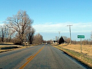
Maysville is an unincorporated community and census-designated place (CDP) in Benton County, Arkansas, United States. It is the westernmost settlement in the state of Arkansas. Per the 2020 census, the population was 117.

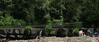
War Eagle is an unincorporated community in Benton County, Arkansas, United States. It is the location of War Eagle Bridge, which carries CR 98 over War Eagle Creek and is listed on the National Register of Historic Places.
Durham is an unincorporated community in eastern Washington County, Arkansas, United States. The community is on Arkansas Highway 16 along the White River valley between Elkins to the northwest and Thompson in Madison County to the southeast. Its elevation is 1,247 feet (380 m).
Natural Dam is an unincorporated community in Crawford County, Arkansas, United States. Natural Dam is located on Arkansas Highway 59, 6 miles (9.7 km) north-northwest of Cedarville. Natural Dam has a post office with ZIP code 72948. Lee Creek Bridge, which is listed on the National Register of Historic Places, is located in the community.

Uniontown is an unincorporated community and census-designated place (CDP) in Crawford County, Arkansas, United States. It is located on Arkansas Highway 220 near the Oklahoma border, 4.5 miles (7.2 km) west-northwest of Cedarville. Uniontown has a post office with ZIP code 72955.

The Benton County Courthouse is a courthouse in Bentonville, Arkansas, United States, the county seat of Benton County, built in 1928. It was listed on the National Register of Historic Places in 1988. The courthouse was built in the Classic Revival style by Albert O. Clark and anchors the east side of the Bentonville Town Square.
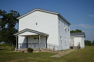
The County Line School and Lodge is a historic multifunction community building in rural western Fulton County, Arkansas. It stands at the junction of County Roads 115 and 236, just east of the county line with Baxter County, west of the small community of Gepp. It is a vernacular two story wood-frame structure with a gable roof and a cast stone foundation. The ground floor houses a school room, and the upper floor was used for meetings of the County Line Masonic Lodge. It was built c. 1879, and was one of the first community buildings to be built in the area. Intended to actually stand astride the county line, a later survey determined it lies a few feet within Fulton County. The building was used as a school until 1948, when the local school systems were consolidated.

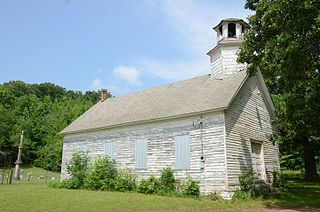
The Concord School House is a historic school building in rural Carroll County, Arkansas. It is located on County Road 309, east of Eureka Springs. It is a single-story wood-frame structure, built in 1886 to serve district 48 students. It was used as a school until 1948, when the area schools were consolidated. After a period of private use for storage, it was purchased by a local charity, moved to its present location, and restored. It is used as an event facility. It is one of two well-preserved one-room schoolhouses in the county.

The Dog Branch School is a historic one-room schoolhouse building in rural southeastern Carroll County, Arkansas. It is located about 3 miles (4.8 km) east of the hamlet of Osage, a short way south of United States Route 412 off County Road 927. It is a single story gable-roofed structure, built out of rough-hewn fieldstone. It has a very limited, vernacular amount of Romanesque Revival and Italianate features, including an arched entry opening and segmented-arch openings for the windows. The school was built in 1898, and is unusual mainly because most district schools built in the region at the time were built out of wood. Its builders, the Bailey Brothers, also built the Stamps Store in Osage.
The Shady Grove Delmar Church and School is a historic church and school building in rural Carroll County, Arkansas, US. The building, a single story wood-frame structure with a gable roof, weatherboard siding, and a distinctive hexagonal tower with belfry and cupola. The building was built c. 1880 to provide a space for both religious services and a district school. It is a virtually unaltered example of the type, which was once common in rural Arkansas. The building is located on County Road 933, about 1.4 miles (2.3 km) west of the hamlet of Delmar, on the north side of Osage Creek.

The No. 12 School is a historic one-room schoolhouse building in rural Crawford County, Arkansas. It is located on the east side of Freedom Road, a short way north of its road junction with Old 12 Cross Roads about 6 miles (9.7 km) west of Chester. It is a single-story wood vernacular frame structure with a small belfry and two entrances. Its date of construction is not documented, but it was being used as a district school in the late 19th century, a role it fulfilled until the area's district schools were consolidated in 1946. It has since served as a community meeting hall.
The Muxen Building is a historic former school building in rural Crawford County, Arkansas. It is located on the west side of United States Route 71 south of Winslow, and next door to the Our Lady of the Ozarks Shrine. It is a single-story stone structure, built out of local fieldstone and set on a concrete foundation. It is covered by a broad hip roof with exposed rafter ends and projecting balconies on two sides. It was built to house a craft school founded by Clara Muxen, a Roman Catholic nun whose inspiration also led to the construction of the adjacent shrine.


