
Wagon Mound is a village in Mora County, New Mexico, United States. It is named after and located at the foot of a butte called Wagon Mound, which was a landmark for covered wagon trains and traders going up and down the Santa Fe Trail and is now Wagon Mound National Historic Landmark. It was previously an isolated ranch that housed four families that served as local traders. The shape of the mound is said to resemble a Conestoga wagon. As of the 2010 census, the village population was 314. It was also called Santa Clara for many years. The village, with brightly painted houses and several stores and shops, is located on the plains of northeastern New Mexico. Interstate 25, which skirts the western side of town, gives a view of the majority of the town. Wagon Mound is not growing rapidly, but it has seen new construction along I-25, with new buildings on the northeast side of town as well.

Clayton is a town and county seat of Union County, New Mexico, United States. As of the 2010 census, the city population was 2,980.

The Santa Fe Trail was a 19th-century route through central North America that connected Franklin, Missouri, with Santa Fe, New Mexico. Pioneered in 1821 by William Becknell, who departed from the Boonslick region along the Missouri River, the trail served as a vital commercial highway until 1880, when the railroad arrived in Santa Fe. Santa Fe was near the end of El Camino Real de Tierra Adentro which carried trade from Mexico City. The trail was later incorporated into parts of the National Old Trails Road and U.S. Route 66.

El Morro National Monument is a U.S. national monument in Cibola County, New Mexico, United States. Located on an ancient east–west trail in the western part of the state, the monument preserves the remains of a large prehistoric pueblo atop a great sandstone promontory with a pool of water at its base, which subsequently became a landmark where over the centuries explorers and travelers have left personal inscriptions that survive today.

The Cimarron River extends 698 miles (1,123 km) across New Mexico, Oklahoma, Colorado, and Kansas. The headwaters flow from Johnson Mesa west of Folsom in northeastern New Mexico. Much of the river's length lies in Oklahoma, where it either borders or passes through eleven counties. There are no major cities along its route. The river enters the Oklahoma Panhandle near Kenton, Oklahoma, crosses the corner of southeastern Colorado into Kansas, reenters the Oklahoma Panhandle, reenters Kansas, and finally returns to Oklahoma where it joins the Arkansas River at Keystone Reservoir west of Tulsa, Oklahoma, its only impoundment. The Cimarron drains a basin that encompasses about 18,927 square miles (49,020 km2).
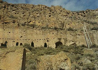
The Puye Cliff Dwellings are the ruins of an abandoned pueblo, located in Santa Clara Canyon on Santa Clara Pueblo Reservation land near Española, New Mexico. Established in the late 1200s or early 1300s and abandoned by about 1600, this is among the largest of the prehistoric Indian settlements on the Pajarito Plateau, showing a variety of architectural forms and building techniques.

Ratón Pass is a 7,834 ft (2,388 m) elevation mountain pass on the Colorado–New Mexico border in the western United States. It is located on the eastern side of the Sangre de Cristo Mountains between Trinidad, Colorado and Raton, New Mexico, approximately 180 miles (290 km) northeast of Santa Fe. Ratón is Spanish for "mouse". The pass crosses the line of volcanic mesas that extends east from the Sangre de Cristo Mountains along the state line, and furnishes the most direct land route between the valley of the Arkansas River to the north and the upper valley of the Canadian River, leading toward Santa Fe, to the south. The pass now carries Interstate 25 and railroad tracks.

The Old Spanish Trail is a historical trade route that connected the northern New Mexico settlements of Santa Fe, New Mexico with those of Los Angeles, California and southern California. Approximately 700 mi (1,100 km) long, the trail ran through areas of high mountains, arid deserts, and deep canyons. It is considered one of the most arduous of all trade routes ever established in the United States. Explored, in part, by Spanish explorers as early as the late 16th century, the trail was extensively used by traders with pack trains from about 1830 until the mid-1850s. The area was part of Mexico from Mexican independence in 1821 to the Mexican Cession to the United States in 1848.

Cimarron National Grassland is a National Grassland located in Morton County, Kansas, United States, with a very small part extending eastward into Stevens County. Cimarron National Grassland is located near Comanche National Grassland which is across the border in Colorado. The grassland is administered by the Forest Service together with the Pike and San Isabel National Forests and the Comanche National Grassland, from common headquarters located in Pueblo, Colorado. There are local ranger district offices in Elkhart, Kansas. The grassland is the largest area of public land in the state of Kansas.

Wagon Bed Spring, also known historically as the Lower Spring or Lower Cimarron Spring, is a historic former spring in Grant County, Kansas, United States. It is located about 12 miles (19 km) south of Ulysses, on the west side of United States Route 270. In the 19th century it was an important watering spot on the Cimarron Cutoff of the Santa Fe Trail, where migrants on the trail often camped. The spring is now dry, primarily due to irrigation lowering the water table in the area. It was declared a National Historic Landmark in 1961.

Point of Rocks is a cliff in Morton County, Kansas which was one of three landmarks by the same name on the Santa Fe Trail. This one was on the Cimarron Cutoff. It is now part of Cimarron National Grassland.

Camp Nichols, also known as Fort Nichols or Camp Nichols Ranch, was a short-lived historic fortification located in present-day Cimarron County, Oklahoma, about 3 miles (4.8 km) northwest of the community of Wheeless, Oklahoma. It was built by New Mexico and California volunteers under the command of Col. Kit Carson to protect travelers on the most dangerous part of the Cimarron Cut-off of the Santa Fe Trail from raids by the Kiowa and Comanche Indians. Established in May 1865 and abandoned in September 1865, it was the only human-made structure along the Cimarron Cut-off while it was an active route. It is believed to have been named for Captain Charles P. Nichols of the First California Cavalry.

Rayado was the first permanent settlement in Colfax County, New Mexico, United States and an important stop on the Santa Fe Trail. The name Rayado derives from the Spanish term for "streaked", perhaps in reference to the lot lines marked out by Lucien Maxwell.

The Rabbit Ears are a pair of mountain peaks in northeastern New Mexico, United States, 8 kilometres (5.0 mi) north of the city of Clayton. The two peaks were a distinctive landmark along the Cimarron Cutoff of the Santa Fe Trail, a major route for westbound settlers in the 19th century. The formation was designated a National Historic Landmark in 1963. The name is that of a Native American chief who was killed here in a battle with the Spanish in 1717.

Watrous, also named La Junta, is a National Historic Landmark District near Watrous, New Mexico. It encompasses the historic junction point of the two major branches of the Santa Fe Trail, a major 19th-century frontier settlement route between St. Louis, Missouri and Santa Fe, New Mexico. La Junta, marked this junction point, as well as the first major indications of civilization before westbound travelers reached Santa Fe. The district includes a large area west of the modern community of Watrous, encompassing the confluence of the Mora and Sapello Rivers. Surviving buildings include the houses of early ranchers, as well as a stagecoach mailstop and inn. The district was designated a National Historic Landmark in 1963.

The Autograph Rock Historic District, in Cimarron County, Oklahoma near Boise City, Oklahoma, is a 58.5-acre (23.7 ha) historic district that was listed on the National Register of Historic Places in 1994. It is associated with NPS Master Plan #123. It includes five contributing sites.

The Enchanted Circle Scenic Byway is a New Mexico Scenic Byway and National Forest Scenic Byway located in Northern New Mexico. It begins and ends in Taos, New Mexico.
Mormon Road, also known to the 49ers as the Southern Route, of the California Trail in the Western United States, was a seasonal wagon road pioneered by a Mormon party from Salt Lake City, Utah led by Jefferson Hunt, that followed the route of Spanish explorers and the Old Spanish Trail across southwestern Utah, northwestern Arizona, southern Nevada and the Mojave Desert of California to Los Angeles in 1847. From 1855, it became a military and commercial wagon route between California and Utah, called the Los Angeles – Salt Lake Road. In later decades this route was variously called the "Old Mormon Road", the "Old Southern Road", or the "Immigrant Road" in California. In Utah, Arizona and Nevada it was known as the "California Road".

Indian Mound is a natural land formation which overlooks the mostly dry river bed of the Arkansas River at what was Chouteau's Island.

The Wagon Mound massacre was an attack on a US Postal Service ox-wagon carried out on May 7, 1850 by a band of Jicarilla Apache and Mouache Ute Indians on the Cimmaron Cutoff route of the Santa Fe Trail, near Wagon Mound, New Mexico. The bodies of the 10 Americans killed in the attack were found in Santa Clara Springs near Wagon Mound by travelers on May 19, 1850, about a week after the attack.


