The Gwydir Highway is a 566-kilometre (352 mi) state highway in northern New South Wales, Australia.

Warialda is a town in the North West Slopes region of New South Wales, Australia, in Gwydir Shire. Situated on the banks of Warialda Creek, the town's name means "Place of Wild Honey."in local aboriginal language. At the 2011 census, Warialda had a population of 1,120.

Gwydir Shire is a local government area located in the New England region of New South Wales, Australia. The northern boundary of the Shire is located adjacent to the border between New South Wales and Queensland.

The Fossickers Way is a series of country roads located in the Northern Tablelands region of New South Wales, Australia that, when joined together, come to form a 379-kilometre (235 mi) scenic and tourist drive. The road's southern terminus is located in Nundle with its northwest terminus in Warialda; thereafter the road joins the Gwydir Highway and heads east to Inverell before reaching its eastern terminus in Glen Innes. The majority of the Fossickers Way is designated as B95.
Myles Dunphy and Milo Dunphy were Australian conservationists who played an important role in creating the Australian wilderness movement.

Northern Tablelands is an electoral district of the Legislative Assembly in the Australian state of New South Wales. It is currently held by Adam Marshall representing the National Party, following a by-election triggered by the resignation of independent member Richard Torbay. The electorate currently includes Uralla Shire, Armidale Regional Council, Glen Innes Severn, Inverell Shire, Gwydir Shire and Moree Plains Shire.
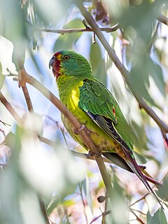
The swift parrot, also known as red-faced parrot or red-shouldered parrot breeds in Tasmania and migrates north to south eastern Australia from Griffith-Warialda in New South Wales and west to Adelaide in the winter. It is related to the rosellas, with the feeding habits of a lorikeet. It is the only member in the genus Lathamus.
The North West Slopes region of New South Wales, Australia, refers generally to the area west of the Northern Tablelands, to the north of the Central West region and to the east of the Far West region. The region corresponds generally to the Australian Bureau of Meteorology's forecast area of North West Slopes and Plains. The administrative areas of the region include the city of Tamworth, Gunnedah, Moree, Narrabri and Inverell.

Mark Maclean Coulton is an Australian politician who has been Minister for Regional Health, Regional Communications and Local Government in the Morrison Government since February 2020. He is a member of the National Party and has served in the House of Representatives since the 2007 federal election, representing the Division of Parkes in New South Wales. He previously served as Minister for Regional Services, Decentralisation and Local Government (2019–2020), Assistant Minister for Trade and Investment (2019–2020), Assistant Minister for Trade, Tourism and Investment (2018–2019), and Deputy Speaker of the House (2016–2018).

Warialda Rail is a town in the New England region of New South Wales, Australia. The town is located 3 km southwest of Warialda in the Gwydir Shire local government area, 581 kilometres (361 mi) north of the state capital, Sydney. At the 2006 census, Warialda Rail and the surrounding area had a population of 345.
James Arthur Clough was an Australian politician. He was the Liberal member for Parramatta in the New South Wales Legislative Assembly from 1956 to 1959, and for Eastwood from 1965 to 1988.

Yallaroi Shire was a local government area located in the New England region of New South Wales, Australia, about 100 kilometres (62 mi) south of Goondiwindi via Fossickers Way. The Shire, administered from the town of Warialda, covered an area of 5,340.1 square kilometres (2,061.8 sq mi), and existed as a local government entity from 1906 until 2004, when it was amalgamated with Bingara Shire and part of Barraba to form the Gwydir Shire.

Hakea laevipes is a shrub in the family Proteaceae. A widespread species found growing on coastal and tableland locations mainly in eastern New South Wales, with scattered populations in south-eastern Queensland.

The Inverell railway line is a closed railway line in New South Wales, Australia. The line branches from the Mungindi line at Moree and travels in an easterly direction through the town of Gravesend then Warialda Rail, gradually increasing in elevation through Delungra towards the terminus at Inverell. An initial estimate of its intended length was 96 miles 35 chains (155.2 km). The line opened in February 1900 as far as Gravesend, then more of the line in 1901 before the Gwydir River bridge was finally finished and the line completed in 1902. It was progressively closed between 1987 and 1994. Currently a 5 km (3.1 mi) section at the Moree end remains in use as a siding for the storage of railway wagons. On 8 August 2016, The NSW Government announced that a 2.8km section of the railway would be reinstated to allow grain to be sent by rail, as part of the Fixing Country Rail pilot round. Up to $2 million was allocated for the project.
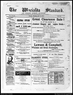
Warialda Standard is a newspaper produced at Warialda, New South Wales. It covers news in the towns of Warialda, Bingara, Coolatai, Croppa Creek, North Star, Yetman, and Delungra.

Persoonia terminalis, also known as the Torrington geebung, is a rare shrub belonging to the family Proteaceae, and native to northern New South Wales and southern Queensland in eastern Australia. Reported as a subspecies of Persoonia nutans in 1981, it was described as a species by Lawrie Johnson and his colleague Peter Weston in 1991.
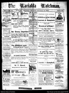
The Warialda Watchman was a weekly English language newspaper published in Warialda, New South Wales, Australia. This newspaper was published by Alfred Wiskens from 12 January 1899 and is believed to have ceased publication in the same year. Some issues were published with supplements.
The Kwiambal were an indigenous Australian people of New South Wales.
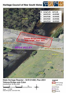
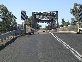
The Yowaka River bridge is a heritage-listed road bridge that carries the Princes Highway across the Yowaka River at Greigs Flat on the Bega Valley Shire local government area of New South Wales, Australia. It was built in 1936. The bridge is also known as the Yowaka Bridge near Eden. The property is owned by Roads and Maritime Services, an agency of the Government of New South Wales. It was added to the New South Wales State Heritage Register on 20 June 2000.
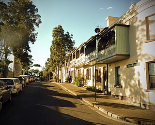
The Merriman Street Terraces are heritage-listed terrace houses located at 20-48 Merriman Street, in the inner city Sydney suburb of Millers Point in the City of Sydney local government area of New South Wales, Australia. It is also known as Davies Terrace. The property was added to the New South Wales State Heritage Register on 2 April 1999.
