Waterville, Kansas

Last updated

Waterville, Kansas
Waterville Opera House.JPG
Waterville Opera House, built in 1904
Marshall County Kansas Incorporated and Unincorporated areas Waterville Highlighted.svg
Location within Marshall County and Kansas
Map of Marshall Co, Ks, USA.png
Coordinates: 39°41′31″N96°44′54″W / 39.69194°N 96.74833°W / 39.69194; -96.74833 [1]
Country United States
State Kansas
County Marshall
Founded1868
Incorporated 1870
Named for Waterville, Maine
Area
[2]
  Total0.51 sq mi (1.31 km2)
  Land0.49 sq mi (1.27 km2)
  Water0.01 sq mi (0.04 km2)
Elevation
[1]
1,175 ft (358 m)
Population
 (2020) [3]
  Total658
  Density1,300/sq mi (500/km2)
Time zone UTC-6 (CST)
  Summer (DST) UTC-5 (CDT)
ZIP code
66548
Area code 785
FIPS code 20-75950
GNIS ID 2397214 [1]
Website cityofwatervilleks.org

Waterville is a city in Marshall County, Kansas, United States. [1] As of the 2020 census, the population of the city was 658. [3]

Contents

History

Waterville was founded in 1868 by the railroad company. [4] It was named after Waterville, Maine, the hometown of a railroad official. [5]

The first post office in Waterville was established in February 1868. [6] Waterville was incorporated as a village in 1870 and as a city the following year. [4]

Geography

According to the United States Census Bureau, the city has a total area of 0.50 square miles (1.29 km2), of which 0.49 square miles (1.27 km2) is land and 0.01 square miles (0.03 km2) is water. [7]

BlueRiverValley.JPG
Waterville lies in the Blue River Valley, with the Little Blue River running just north of its city limits.

Demographics

Historical population
CensusPop.Note
1880 615
1890 577−6.2%
1900 6105.7%
1910 70415.4%
1920 665−5.5%
1930 598−10.1%
1940 71719.9%
1950 676−5.7%
1960 7003.6%
1970 632−9.7%
1980 6949.8%
1990 601−13.4%
2000 68113.3%
2010 680−0.1%
2020 658−3.2%
U.S. Decennial Census

2010 census

As of the census [8] of 2010, there were 680 people, 294 households, and 192 families residing in the city. The population density was 1,387.8 inhabitants per square mile (535.8/km2). There were 331 housing units at an average density of 675.5 per square mile (260.8/km2). The racial makeup of the city was 98.4% White, 0.3% African American, 0.1% Native American, 0.1% from other races, and 1.0% from two or more races. Hispanic or Latino of any race were 2.2% of the population.

There were 294 households, of which 29.3% had children under the age of 18 living with them, 51.7% were married couples living together, 9.2% had a female householder with no husband present, 4.4% had a male householder with no wife present, and 34.7% were non-families. 30.3% of all households were made up of individuals, and 19.4% had someone living alone who was 65 years of age or older. The average household size was 2.31 and the average family size was 2.90.

The median age in the city was 41 years. 26.2% of residents were under the age of 18; 5.3% were between the ages of 18 and 24; 22.5% were from 25 to 44; 23.6% were from 45 to 64; and 22.5% were 65 years of age or older. The gender makeup of the city was 47.1% male and 52.9% female.

2000 census

As of the census [9] of 2000, there were 681 people, 292 households, and 190 families residing in the city. The population density was 1,351.1 inhabitants per square mile (521.7/km2). There were 328 housing units at an average density of 650.7 per square mile (251.2/km2). The racial makeup of the city was 97.50% White, 0.29% Asian, 0.15% from other races, and 2.06% from two or more races. Hispanic or Latino of any race were 1.17% of the population.

There were 292 households, out of which 28.8% had children under the age of 18 living with them, 54.5% were married couples living together, 8.2% had a female householder with no husband present, and 34.6% were non-families. 32.2% of all households were made up of individuals, and 21.9% had someone living alone who was 65 years of age or older. The average household size was 2.33 and the average family size was 2.94.

In the city, the population was spread out, with 26.7% under the age of 18, 5.4% from 18 to 24, 22.9% from 25 to 44, 20.4% from 45 to 64, and 24.5% who were 65 years of age or older. The median age was 40 years. For every 100 females, there were 89.7 males. For every 100 females age 18 and over, there were 82.8 males.

The median income for a household in the city was $31,136, and the median income for a family was $38,472. Males had a median income of $29,107 versus $18,000 for females. The per capita income for the city was $18,833. About 8.0% of families and 10.7% of the population were below the poverty line, including 13.6% of those under age 18 and 9.6% of those age 65 or over.

Education

The community is served by Valley Heights USD 498 public school district. Valley Heights Jr/Sr High School is located halfway between the towns of Blue Rapids and Waterville. The Valley Heights mascot is Mustangs. [10]

Waterville High School was closed through school unification. The Waterville High School mascot was Waterville Yellow Jackets. [11]

Notable people

See also

Related Research Articles

<span class="mw-page-title-main">Marshall County, Kansas</span> County in Kansas, United States

Marshall County is a county located in the U.S. state of Kansas. Its county seat and largest city is Marysville. As of the 2020 census, the county population was 10,038. The county was named after Frank J. Marshall, a state representative who operated the first ferry over the Big Blue River.

<span class="mw-page-title-main">Kiowa, Kansas</span> City in Kiowa County, Kansas

Kiowa is a city in Barber County, Kansas, United States. As of the 2020 census, the population of the city was 902. It is located 1 mile north of the Kansas / Oklahoma state border.

<span class="mw-page-title-main">Protection, Kansas</span> City in Comanche County, Kansas

Protection is a city in Comanche County, Kansas, United States. As of the 2020 census, the population of the city was 498.

<span class="mw-page-title-main">Elwood, Kansas</span> City in Doniphan County, Kansas

Elwood is a city in Doniphan County, Kansas, United States, located west across the Missouri River from Saint Joseph, Missouri. As of the 2020 census, the population of the city was 1,125.

<span class="mw-page-title-main">Lane, Kansas</span> City in Franklin County, Kansas

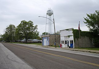
Lane is a city in Franklin County, Kansas, United States. As of the 2020 census, the population of the city was 241.

<span class="mw-page-title-main">Princeton, Kansas</span> City in Franklin County, Kansas

Princeton is a city in Franklin County, Kansas, United States. As of the 2020 census, the population of the city was 248.

<span class="mw-page-title-main">Rantoul, Kansas</span> City in Franklin County, Kansas

Rantoul is a city in Franklin County, Kansas, United States. As of the 2020 census, the population of the city was 165.

<span class="mw-page-title-main">Richmond, Kansas</span> City in Franklin County, Kansas

Richmond is a city in Franklin County, Kansas, United States. As of the 2020 census, the population of the city was 459.

<span class="mw-page-title-main">Gove City, Kansas</span> City in Gove County, Kansas

Gove City, more commonly known as Gove, is a city in and the county seat of Gove County, Kansas, United States. As of the 2020 census, the population of the city was 80.

<span class="mw-page-title-main">Webber, Kansas</span> City in Jewell County, Kansas

Webber is a city in Jewell County, Kansas, United States. As of the 2020 census, the population of the city was 30.

<span class="mw-page-title-main">Blue Rapids, Kansas</span> City in Marshall County, Kansas

Blue Rapids is a city in Marshall County, Kansas, United States. As of the 2020 census, the population of the city was 928.

<span class="mw-page-title-main">Plains, Kansas</span> City in Meade County, Kansas

Plains is a city in Meade County, Kansas, United States. As of the 2020 census, the population of the city was 1,037. It is located along U.S. Route 54 highway. It is notable for the width of its main street which is the widest in the United States at 155 feet 5 inches (47.37 m) across.

<span class="mw-page-title-main">Burdett, Kansas</span> City in Pawnee County, Kansas

Burdett is a city in Pawnee County, Kansas, United States. As of the 2020 census, the population of the city was 228.

<span class="mw-page-title-main">Rozel, Kansas</span> City in Pawnee County, Kansas, United States

Rozel is a city in Pawnee County, Kansas, United States. As of the 2020 census, the population of the city was 102.

<span class="mw-page-title-main">Agra, Kansas</span> City in Phillips County, Kansas

Agra is a city in Phillips County, Kansas, United States. As of the 2020 census, the population of the city was 208.

<span class="mw-page-title-main">Kirwin, Kansas</span> City in Phillips County, Kansas

Kirwin is a city in Phillips County, Kansas, United States. As of the 2020 census, the population of the city was 139.

<span class="mw-page-title-main">Belleville, Kansas</span> City in Republic County, Kansas

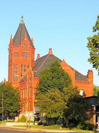
Belleville is a city in and the county seat of Republic County, Kansas, United States. As of the 2020 census, the population of the city was 2,007.

<span class="mw-page-title-main">Viola, Kansas</span> City in Sedgwick County, Kansas

Viola is a city in Sedgwick County, Kansas, United States. As of the 2020 census, the population of the city was 115.

<span class="mw-page-title-main">Kismet, Kansas</span> City in Seward County, Kansas

Kismet is a city in Seward County, Kansas, United States. As of the 2020 census, the population of the city was 340. It is located along U.S. Route 54 highway.

<span class="mw-page-title-main">Kensington, Kansas</span> City in Smith County, Kansas

Kensington is a city in Smith County, Kansas, United States. As of the 2020 census, the population of the city was 399.

References

  1. 1 2 3 4 U.S. Geological Survey Geographic Names Information System: Waterville, Kansas
  2. "2019 U.S. Gazetteer Files". United States Census Bureau. Retrieved July 24, 2020.
  3. 1 2 "Profile of Waterville, Kansas in 2020". United States Census Bureau. Archived from the original on May 28, 2022. Retrieved May 28, 2022.
  4. 1 2 Blackmar, Frank Wilson (1912). Kansas: A Cyclopedia of State History, Volume 2. Standard Publishing Company. pp.  895.
  5. Foster, Emma Elizabeth Calderhead (1917). History of Marshall County, Kansas: Its People, Industries, and Institutions. B.F. Bowen. pp.  197.
  6. "Kansas Post Offices, 1828-1961, page 2". Kansas Historical Society. Retrieved June 14, 2014.
  7. "US Gazetteer files 2010". United States Census Bureau . Retrieved July 6, 2012.
  8. "U.S. Census website". United States Census Bureau . Retrieved July 6, 2012.
  9. "U.S. Census website". United States Census Bureau . Retrieved January 31, 2008.
  10. "Valley Heights USD 498". USD 498. Retrieved January 5, 2017.
  11. "Waterville Rolls By Riley County", The Manhattan Mercury, 12 January 1964, p.3.

Further reading