Manito Park, also called Manito Park and Botanical Gardens is a 90-acre (0.36 km2) public park with arboretum, botanical gardens, and conservatory, located at 17th Ave and Grand Blvd in the Manito/Cannon Hill neighborhood of Spokane, Washington, United States. It is open daily without charge.

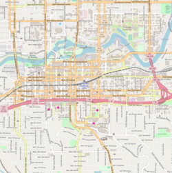
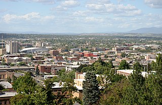
Downtown Spokane or Riverside is the central business district of Spokane, Washington. The Riverside neighborhood is roughly bounded by I-90 to the south, Division Street to the east, Monroe Street to the west and Boone Avenue to the north. The topography of Downtown Spokane is mostly flat except for areas downstream of the Spokane Falls which are located in a canyon; the elevation is approximately 1,900 feet (580 m) above sea level.

Knickerbocker is a historic Beaux Arts building in the Cliff/Cannon neighborhood of Spokane, Washington. It was designed by architect Albert Held and was built in 1911. It was listed on the National Register of Historic Places in 1987. The building is also listed on the Spokane Register of Historic Places, under the name Knickerbocker Apartments.

The San Marco is a historic Renaissance Revival apartment building in Downtown, Spokane, Washington that was built in 1904. It was designed by architect Albert Held. San Marco was listed on the U.S. National Register of Historic Places in 1987. It is also listed on the NRHP as a contributing property in the Riverside Avenue Historic District.

West Central is a neighborhood in Spokane, Washington. As the name suggests it is located centrally on the west side of the city. Downtown Spokane is immediately east of the neighborhood, and spreads into West Central along Monroe Street in the Kendall Yards area. The neighborhood is diverse, with single and multi-family residential zones dating back to the early days of Spokane, a new mixed use development on the site of a former rail yard, the Spokane County Courthouse campus and associated government buildings and a few commercial districts. The Spokane River gorge winds around the southern and western edge of the neighborhood. It is home to Nettleton's Addition Historic District, which was added to the National Register of Historic Places in March 2006, and is also the largest historic district on the Washington State Heritage Register.

The Riverside Avenue Historic District is a 16.5 acres (6.7 ha) historic district in Downtown Spokane, Washington consisting of buildings constructed in the early 20th century, and was listed on the National Register of Historic Places in 1976. The listing includes 14 contributing properties, nine of which are considered primary and five are considered secondary.

The Eldridge Building is a historic building in Spokane, Washington. It was designed by architect Gustav Albin Pehrson, and built in 1925. It has been listed on the National Register of Historic Places (NRHP) since November 12, 1992. It is one of three historic buildings listed on the NRHP at the intersection of First Avenue and Cedar Street. To the west across Cedar is the Grand Coulee building and to the northwest, kitty-corner from the Eldridge Building, is the former Carnegie Library.

The University District, also referred as the U-District or Spokane University District, is a 770-acre area, tax increment financing, and innovation district in Spokane, Washington. It is located just east of its Downtown Spokane in the East Central and Logan neighborhoods, and is home to a number of higher education institutions and their surrounding neighborhoods.

East Central is a neighborhood in Spokane, Washington. As the name suggests, it is on the east side of Spokane and centrally located. The official neighborhood is expansive and covers multiple areas considered by locals to be independent neighborhoods, such as the Sprague Union District on East Sprague Avenue, the South Perry District, the Underhill Park area and the University District on the eastern fringe of Downtown Spokane.

Browne's Addition, often referred to shorthand as just Browne's, is a neighborhood in Spokane, Washington. It is located directly west of Downtown Spokane and is one of the oldest and densest neighborhoods in the city. The area is known for its numerous historic mansions, many of which have been converted into multi-family apartments. The terrain is flat in the neighborhood despite the degree of topographical relief in the immediate surrounding area. Latah Creek cuts a deep valley to the west, separating Browne's Addition from the Sunset Hill portion of the West Hills neighborhood and the Spokane River gorge drops off dramatically to the north into the Peaceful Valley neighborhood. The South Hill area of Spokane rises to the southwest.
Peaceful Valley is a neighborhood in Spokane, Washington. It sits directly below Downtown Spokane on the Spokane River under its falls. The neighborhood snakes along the thin floodplain on the valley floor of the Spokane River Gorge. It is the smallest neighborhood in the city by both area and population, but due to its central location and unique character it is quite notable. The neighborhood has a working class and bohemian culture.

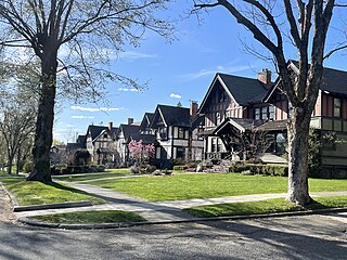
Spokane and its neighborhoods contain a patchwork of architectural styles that give them a distinct identity and illustrate the changes throughout the city's history. Spokane has a rich architectural history for a western city of its size and much of it is a product of its circumstances at the turn of the 20th century when as a rapidly growing city, the Great Fire of 1889 destroyed 32 blocks of the city center which was quickly rebuilt in a more grand fashion by a community flush with money coming from regional mining districts. Many of the architects that found work in the city and building on the blank slate of the downtown commercial district became highly esteemed architects such as Kirtland Cutter, who has been credited with giving the city a distinctive character. In particular, the city has a high concentration of Romanesque Revival style institutional and commercial buildings and American Craftsman bungalow residences. The architecture of Spokane gained national recognition in industry publications in the early 20th century.
Cliff/Cannon is a neighborhood in Spokane, Washington. It is located immediately south of Downtown, Spokane, and on the lower reaches of the broader South Hill. The neighborhood is home to a medical district with Sacred Heart and Deaconess both having their main hospital campuses along Cliff/Cannon's denser northern edge. To the south the neighborhood becomes more residential. City parks break up the residential zoning of the southern half of Cliff/Cannon. It is adjacent to the Cannon Hill area of the neighboring but separate Manito/Cannon Hill neighborhood. The Marycliff-Cliff Park Historic District, a National Historic District listed on the National Register of Historic Places, is located within the neighborhood.
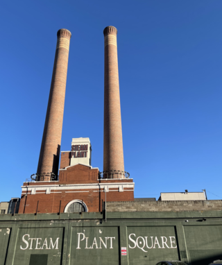
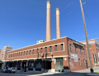
The Central Steam Heat Plant, commonly known as Steam Plant Square, or simply as the Steam Plant, is a historic building in Downtown Spokane, Washington. Originally built to provide steam heating to more than 300 buildings in Spokane's city center, the Steam Plant served that purpose until the 1980s, when it was no longer viable. In the 1990s, the Steam Plant and adjacent Seehorn-Lang Building were converted into Steam Plant Square, a commercial, retail and restaurant center. The conversion maintained many of the industrial steam plant structures such as furnaces, boilers, catwalks and pipe networks, which can still be seen and explored by visitors and patrons. The Steam Plant's pair of 225-foot-tall stacks have been a unique and iconic aspect of the city's skyline for more than a century, and are illuminated from their base at night. If the stacks were considered to be a building, they would rank as the third tallest in the city.
The Seehorn-Lang Building is a historic building in Downtown Spokane, Washington. Since the late 1990s it has been commonly known as part of Steam Plant Square, a commercial and retail center which it forms together with the adjacent Central Steam Heat Plant building. Built in 1890, it is one of the oldest buildings in Spokane, as many buildings constructed prior were destroyed in the Great Spokane Fire of 1889. The building is listed on the National Register of Historic Places (NRHP) as well as the state and local historic registers. Additionally, it is a contributing property in the West Downtown Historic Transportation Corridor, a historic district added to the NRHP in 1999.
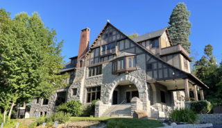
The Glover Mansion is a historic Tudor revival home built in 1888 and located in the Cliff/Cannon neighborhood of Spokane, Washington, just uphill from and overlooking the city's downtown. The home was designed by architect Kirtland Cutter for James N. Glover, who founded the city of Spokane in 1873. Over the years the Glover Mansion has served as a residence, housed Spokane's Unitarian Universalist Church, and more recently been used as an event venue.

Doyle's Ice Cream Parlor is a locally owned ice cream shop that has been located in Spokane's West Central neighborhood since 1939. Doyle's is open from spring to early fall, Wednesdays through Sundays.

The Nettleton's Addition Historic District is a historic residential district in the West Central neighborhood of Spokane, Washington. It was listed on the National Register of Historic Places (NRHP) in 2006 because of the concentration of historic homes in one of Spokane's oldest residential neighborhoods and for its significance as an example of community planning and development and in the area of architecture. It is the largest national historic district in the state of Washington.
The Ninth Avenue Historic District is a National Register of Historic Places (NRHP) listed historic district located along and around Ninth Avenue in the Cliff/Cannon neighborhood of Spokane, Washington. It stretches from Monroe Street on the east to Chestnut Street on the west, running the length of Ninth Avenue and extending to include portions of Eighth, 10th and 11th Avenues, mostly in the western half of the district.

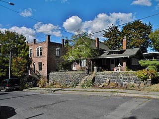
The Peaceful Valley Historic District is a National Register of Historic Places-listed historic district in the Peaceful Valley neighborhood of Spokane, Washington. It is located in the western half of the neighborhood, along the floor and southern slope of the Spokane River Gorge, immediately south of the Spokane River and downhill, just below Downtown Spokane. It is centered on the intersection of Main Avenue and Maple Street, stretching from there approximately two blocks in each direction.